Bosque del Apache NWR--Seasonal Tour Road (closed Oct. 1 - Mar. 31)
Bosque del Apache NWR--Seasonal Tour Road (closed Oct. 1 - Mar. 31)
San Antonio, New Mexico 87832
Bosque del Apache National Wildlife Refuge websiteFriends of Bosque del Apache NWR website
Bosque del Apache NWR Important Bird Area (Audubon) website
Habitat! Guide to Bosque del Apache NWR booklet
Bosque del Apache National Wildlife Refuge map
Tips for Birding
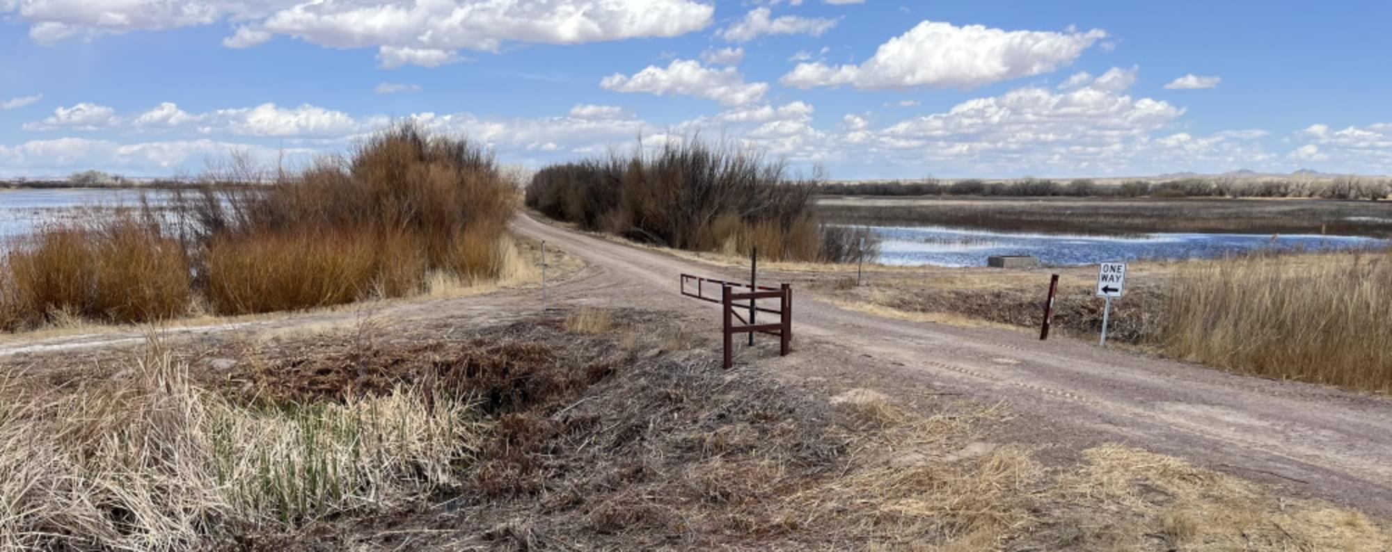
About midway along the Main East-West Road, just east of the Eagle Deck, the one-way, 2.2-mile, and dirt-surfaced Seasonal Tour Road extends north, rejoining the North Loop north of the Coyote Deck. Despite being closed 6 months during fall and winter to minimize waterfowl disturbance, over 250 species have been observed at this hotspot, making it (as of Spring 2022) one of the top 20 in the state. Typically open April 1 through September 30, this is an excellent area at which to view spring migrants, particularly wading birds and flycatchers, while at the same time experiencing waterfowl that have lingered from winter.
The first half-mile of the road takes you between two large fields. On your left is the Flight Deck field, which by April 1 has likely been flooded for many months and though in the process of being drained still appears to be a large pond, whereas the field on your right has probably only begun to be flooded and has more vegetation, including a few cottonwoods, showing. By October, when the road is closed, these fields, and indeed all of the fields along the road, will look much different due to water management practices. The fields are not constantly visible as you travel the road, because willow, cane, and sunflowers line the edges, but breaks in the vegetation wall allow good front-lit west viewing in the mornings with eastward viewing better in the afternoon. There are only a few areas where you can pull far enough off the road to permit other birders to pass (or you to park your vehicle and walk back to a viewing “window” in the vegetation), so please be mindful of traffic.
At the end of these two fields is a dog-leg crossroads formed with the maintenance road along a roughly east-west ditch known as the Mohawk Ditch. The maintenance roads are not for public access and should not be blocked, but you may find space to park where you can get out and better view birds up and down the ditch.
Beyond the ditch, the road heads roughly northeast. You will pass five fields on your right before the road turns sharply southeast, around the last of the five. The fields, managed as seasonal wetlands, will be flooded to varying degrees; though extending almost to the North Loop, you get a closer view of these fields from the Seasonal Tour Road because there is no ditch or maintenance road between you and the fields as there would be if you were on the North Loop. On your left, the large mesquite- and cottonwood-dotted grassland was purposely burned to remove invasive plants in early 2022; the view of that area is apt to be blocked by vegetation, but it is in this dense roadside cover you will often find spring flycatchers.
Approximately a quarter mile after the southeast turn, the road resumes a northeasterly direction, paralleling the North Loop, with a ditch between the two roads. At first, semi-permanent marshland lies to the left, with the following seasonal wetlands usually dry by the time the Seasonal Tour Road opens. Birders should look for wild turkeys near the trees in the first of these now-dry fields. It is also worthwhile to examine the underside of the Willow and Coyote decks as you pass them on your right.
The value of eBird data to both birders and researchers is enhanced by an accurate recording of where you saw the birds. Researchers and other birders will appreciate your effort to differentiate observations among the specific hotspots. However, if you are going to record all your refuge observations in a single list, please use the Bosque del Apache NWR hotspot: do not use one of the more precise hotspots for a list of birds seen at multiple locations. This is especially important to remember regarding the Seasonal Tour Road, as it can only be accessed by first traveling on the Main East-West Road, and to exit the refuge you must travel on the North Loop, both separate hotspots.
About Bosque del Apache National Wildlife Refuge
See all hotspots at Bosque del Apache National Wildlife Refuge
Established in 1939 to provide a critical stopover for migrating waterfowl, the refuge is well known for the thousands of sandhill cranes, geese, and other waterfowl that winter here each year.
Situated between the Chupadera Mountains to the west and the San Pascual Mountains to the east, the 57,331-acre refuge harbors a wild stretch of the Rio Grande, a ribbon of cottonwood and willow trees visible on the landscape from distant mesas.
Petroglyphs tell the story of ancient people who lived and hunted here. The river and its diversity of wildlife have drawn humans to this area for at least 11,000 years when humans migrated along this corridor, sometimes settling to hunt, fish, and farm. Artifacts and stone tools found nearby tell us that nomadic Paleo-Indian hunters pursued herds of mammoth and bison in the valley.
Today, Bosque del Apache is part of the National Wildlife Refuge System, a national network of lands and waters set aside and managed for the benefit of wildlife, habitat, and you.
Features
Restrooms on site
Wheelchair accessible trail
Entrance fee
Roadside viewing
Content from Bosque del Apache National Wildlife Refuge website, Birding in New Mexico (National Audubon Society), and John Montgomery
Last updated March 10, 2024
