Bosque del Apache NWR--North Loop (formerly Farm Loop)
Bosque del Apache NWR--North Loop (formerly Farm Loop)
San Antonio, New Mexico 87832
Bosque del Apache National Wildlife Refuge websiteFriends of Bosque del Apache NWR website
Bosque del Apache NWR Important Bird Area (Audubon) website
Habitat! Guide to Bosque del Apache NWR booklet
Bosque del Apache National Wildlife Refuge map
Tips for Birding
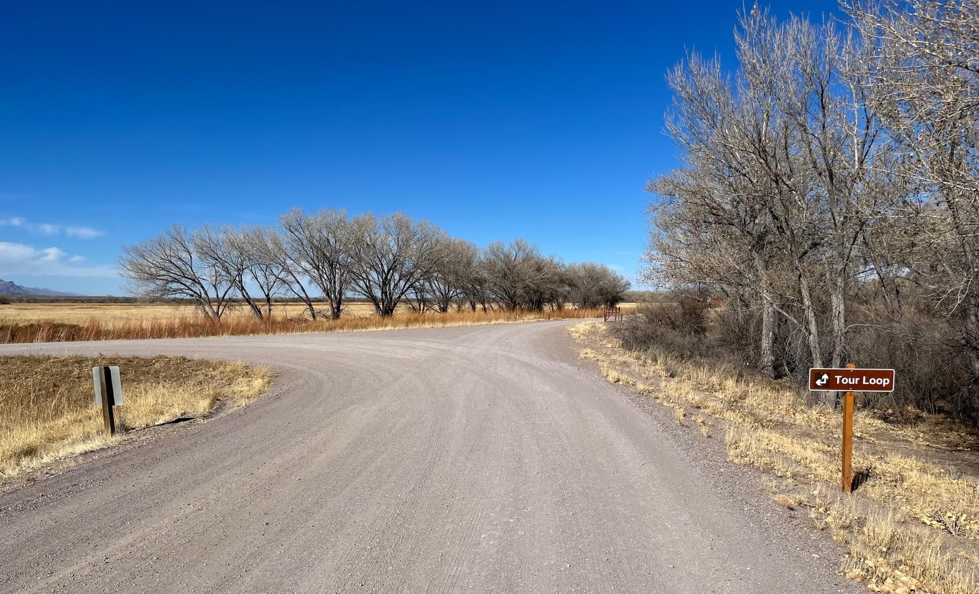
This hotspot is the north portion of the Refuge Auto Tour Loop; despite its name, the North Loop is not itself a loop, but rather just half a loop. The Main 2-Way (East-West) Road allows the birder to make a loop without venturing on the south portion of the Auto Tour Loop, but the East-West Road is a separate hotspot, and sightings along it should not be included in lists for the North Loop. Along its route, the North Loop provides views of or access to two specific hotspots, the Phil Norton Observation Blind and the Flight Deck, which both have distinct parking areas. The value of eBird data to birders and researchers is enhanced by an accurate and precise recording of where you saw the birds. So, if you explore either of these two specific hotspots, it is appreciated that you record your sightings for the appropriate location. However,
For all of its length except the .075-mile section passing by the Flight Deck, the North Loop is a one-way road. The North Loop (6.5 miles long, not including the Farm Extension) starts where the South Loop ends, at the east end of the East-West Road, before that road taking you into the parking area for the Bike Trail and Rio Viejo Trail. The gate marking the entrance to the North Loop can be closed if the USFWS is conducting maintenance or a prescribed burn, sometimes not decided upon until the day before (due to weather); be prepared by checking the Bosque del Apache National Wildlife Refuge website for alerts immediately before your trip. You may encounter bikers and hikers along the route; the road surface is gravel, so drive no more than the speed limit, not only for safety but also to reduce the dust otherwise suffered by those you pass or those following. Again for safety, as well as courtesy, pull well off to the side of the road should you stop, being sure not to leave your door open on the traffic side of the road. During peak visitation times, traffic can be heavy.
Not surprisingly, the road initially heads north from the gate, passing by seasonal wetlands on the west and cottonwood bosque on the east. The Riverside Ditch, and a maintenance road (a portion of which serves as part of the Seasonal Tour Road during summer) to its west, lie between the North Loop and these wetland fields. In places, cottonwoods on the east edge of these fields obscure wetlands view; yet, in these same trees are often found raptors, woodpeckers, and seasonal passerines. Less than 1.5 miles from its beginning, the Willow Deck, which extends over the ditch, offers an unobscured wetlands view. The Coyote Deck, less than a quarter-mile further north provides a similar opportunity. About 200 yards north of that deck, the Seasonal Tour Road (also one-way) joins the North Loop from the west. Approximately where the Audio 12 marker is located, about 2.5 miles along the North Loop, the wetlands give way to grassland mixed with mesquite, together with a few cottonwood and tamarisk.
A quarter-mile farther, the main portion of the North Loop turns west, but you may have the option of continuing north through a gate onto what is generally known as the North Farm Extension. This road, not drawn on some maps, has a well-maintained gravel surface like the North Loop proper but is in places narrower, notably where it turns west to cross the Riverside Ditch. There is a wide area that can accommodate a few cars directly after this crossing; if you park here to get out and explore, be sure not to block the maintenance road on the west side of the ditch. At 2 miles, the road turns south, with a copse of cottonwood bosque to the left, re-joining the North Loop after 3.25 miles. As its name implies, the Farm Extension takes you through cropland habitats, which may be planted or fallow; in fallow fields, look for sunflowers attracting Pine Siskin and Lesser Goldfinch. Though cropland is typically planted with triticale and corn to fuel wintering waterfowl, the Farm Extension is one of the best places on the Refuge to find Rio Grande Wild Turkey. eBirders should feel free to build a separate list for the Farm Extension, indicating in their “Checklist Comments” that the list’s observations are only for this portion of the North Loop, or to identify an individual species “Details” that the observation was on the Extension rather than the main North Loop. This would help re-allocate lists, should the Extension ever become a specific hotspot.
If instead of taking the Farm Extension, you turn west, following the main North Loop, after about a quarter-mile you’ll find a convenient pull-out which was at one time the parking area for a deck no longer present. The Loop continues for almost a mile farther, having on the north, cropland, and on the south, grassland interspersed primarily with mesquite, before it is joined (just east of the Audio 13 marker) by the end of the Farm Extension.
Limited parking may be available at the northeast corner of this intersection. From here, depending on the season, availability of water, and management decisions, the field directly northwest can appear to be a pond or a field of packed earth with some native grasses. This is the field seen to the east if you are on the Observation Blind trail. When flooded during late fall and early winter, the field attracts thousands of geese, ducks, and Sandhill Cranes so can be quite congested with observers. As the Farm Extension joins the North Loop here, it passes over the Elmendorf Ditch, offering an opportunity to glass the ditch in both directions; the ditch is lined with willow and kochia which elsewhere obscure the view into the ditch. Visitors are not allowed on the maintenance road on the north side of the ditch.
Immediately past the Observation Blind, as the North Loop turns south, visitors will notice that the USFWS, during 2021 and 2022, rooted out and burned tamarisk in the area to the east. This emphasizes that given the active management of the northern part of the Refuge, what you see from the North Loop may be very different from one year to the next – even during the same season. This burned area extends for over a mile, almost as far as where two-way traffic begins at the east-west ditch which marks the north end of the Flight Deck hotspot.
Two final tips…
If you have time, and it is open, the more interesting option is generally to take the Farm Extension. Unless it is peak waterfowl season, and there is corn being bumped down for cranes and geese in the fields directly north of the main North Loop between where the Farm Extension begins and ends, you are likely to see more species, as well as a greater number of birds, by taking the Farm Extension than by continuing on that short section of the North Loop itself.
Most of the time on the North Loop, not including from the Observation Blind Trail or Flight Deck, you will be looking west or north. Therefore, mornings offer better lighting for identification and photography.
About Bosque del Apache National Wildlife Refuge
See all hotspots at Bosque del Apache National Wildlife Refuge
Established in 1939 to provide a critical stopover for migrating waterfowl, the refuge is well known for the thousands of sandhill cranes, geese, and other waterfowl that winter here each year.
Situated between the Chupadera Mountains to the west and the San Pascual Mountains to the east, the 57,331-acre refuge harbors a wild stretch of the Rio Grande, a ribbon of cottonwood and willow trees visible on the landscape from distant mesas.
Petroglyphs tell the story of ancient people who lived and hunted here. The river and its diversity of wildlife have drawn humans to this area for at least 11,000 years when humans migrated along this corridor, sometimes settling to hunt, fish, and farm. Artifacts and stone tools found nearby tell us that nomadic Paleo-Indian hunters pursued herds of mammoth and bison in the valley.
Today, Bosque del Apache is part of the National Wildlife Refuge System, a national network of lands and waters set aside and managed for the benefit of wildlife, habitat, and you.
Features
Entrance fee
Roadside viewing
Restrooms on site
Content from Bosque del Apache National Wildlife Refuge website, Birding in New Mexico (National Audubon Society), and John Montgomery
Last updated March 10, 2024
