Pt. Reyes--Fish Docks (DO NOT INCLUDE Chimney Rock area)
Pt. Reyes--Fish Docks (DO NOT INCLUDE Chimney Rock area)
Inverness, California 94937
Point Reyes National Seashore Official WebsitePoint Reyes National Seashore map
Tips for Birding
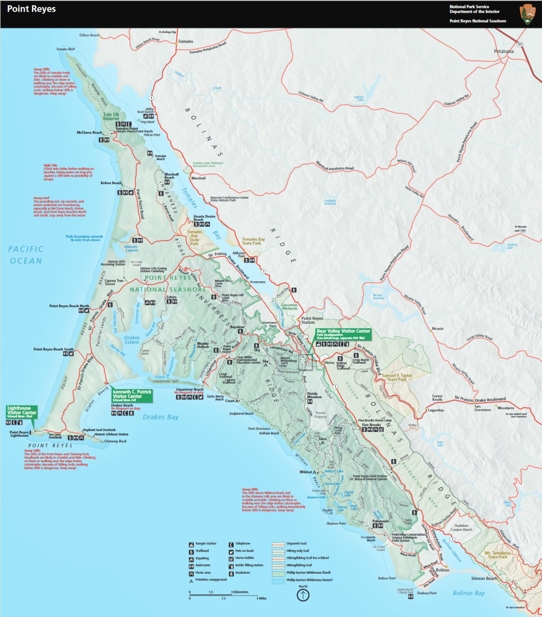
Park at the main parking lot for Chimney Rock. This is a popular hike for tourist so be prepared to park on the entrance road and walk in if you don't arrive early. Stay left on the paved trail going down from the parking lot until you reach a T junction (37.9957088, -122.9791516). This can be a good spot to check the bay for scoters, loons, and alcids. Take a right towards the cypresses to head to the main section at Fish Docks. Good spots for migrants and vagrants include the Amphitheatre (37.9956765, -122.9781974), accessed by taking a left on a hidden trail by the water container, the hillside cypresses (37.9946772, -122.9778685), and the pines (37.9948881, -122.9764935), which is often the most productive spot for vagrant warblers. The Fish Docks, like most other spots on the Outer Point, are most productive after nights with high overcast and light S-SE winds during migration.
Birds of Interest
Vagrants
About this Location
The Fish Docks at Point Reyes are one of the best migrant traps in California. Situated right along the tip of the Point Reyes peninsula, the abundant cypress provide habitat for a many migrating birds. The area was first settled in 1927 when the Coast Guard moved their Point Reyes headquarters to this protected spot along Drake's Bay. The lifeboat house, situated at the east ends of fish docks proper, was where rescue boats were launched from. Today, the spot is popular for tourists who start their hikes to Chimney Rock from here. Elephant Seals can commonly be seen on the beach by the lifeboat house as well as from the Elephant Seal overlook trail, along the way to New Willows.
About Point Reyes National Seashore
See all hotspots at Point Reyes National Seashore
The cultural history of Point Reyes reaches back some 5,000 years to the Coast Miwok Indians who were the first human inhabitants of the Peninsula. Over 120 known village sites exist within the park. According to many experts, Sir Francis Drake landed here in 1579, the first European explorer to do so. In response to the many shipwrecks in the treacherous coastal waters, key lighthouse and lifesaving stations were established by the United States Government in the late 1800s and early 1900s. In the early 1800s, Mexican land grantees established ranchos. They were followed by a wave of American agricultural operations, which continue to this day in the Seashore's pastoral zone. By 1914, Guglielmo Marconi sited and commissioned the building of a wireless telegraphy station in the Point Reyes area, which played an important role in maritime communications for ships on the Pacific Ocean through the late 1900s.
As wildland habitat is lost elsewhere in California, the relevance of the Point Reyes Peninsula increases as a protected area with a notable rich biological diversity. Over 45% of North American avian species and nearly 18% of California's plant species are found in the park due to the variety of habitats and uniqueness of the geology. Thirty federally listed threatened and endangered species of animals and six federally listed threatened or endangered species of plants exist within the Seashore.
Even if you can only visit here for a day, you will begin to see what we have at Point Reyes National Seashore and how it works. As you drive through windswept Bishop pines, hike up Mt. Wittenberg under towering Douglas firs, or walk along Bear Valley Trail through mixed woodlands to the exposed coastal scrub near the ocean, you will begin to see patterns. You might ask yourself why certain plant communities grow in certain places.
Their placement began with ancient geologic forces that created the bedrock and soils. Particular characteristics in these soils determine which types of plants can survive in different locations. Hills, valleys, and exposure provide further discrimination for plants, depending on their sunlight needs and tolerance to winds. Nothing is random in what you are observing, plants grow where they can survive forming the foundations of all other life including our own.
During your exploration, you may also catch a glimpse of some of the animals that make their home here. Wildlife abounds throughout the Seashore. Along the coast, you may find marine mammals such as whales, harbor or elephant seals, and sea lions. A closer look reveals an abundance of bird life feeding near the tideline. Back in the forest, you may glimpse a bobcat, coyote, raccoon, or skunk scurrying off. We also have plenty of deer and elk to be seen.
About Pt. Reyes--Outer Point
See all hotspots at Pt. Reyes--Outer Point
Outer Point Reyes is the westernmost part of Point Reyes National Seashore, and is the area that has received the most scrutiny by birders looking for vagrants over the past 50 years. Typically defined as the area from historic E ranch westward, the majority of Point Reyes's most productive vagrant traps sit on this approximately 12 square mile piece of land. The majority of habitat here is a mix of native scrub and open fields using for grazing. The lack of trees on the outer peninsula draw vagrants to each of the small groves at the ranches and POIs. Other than these few planted dypresses and pines, there's a few small willow groves, specifically at New Willows and Drakes Beach. While spots like the Fish Docks, Lighthouse, and Nunes ranch get covered the most by birders, almost any location can be productive in producing a rarity.
Notable Trails
Features
Restrooms on site
Wheelchair accessible trail
Entrance fee
Roadside viewing
Content from Point Reyes National Seashore Official Website
Last updated July 6, 2023
 Outer Point Map