Maple Ridge Trail
Maple Ridge Trail
Stowe, Vermont 05672
Official WebsiteMt. Mansfield Official Website
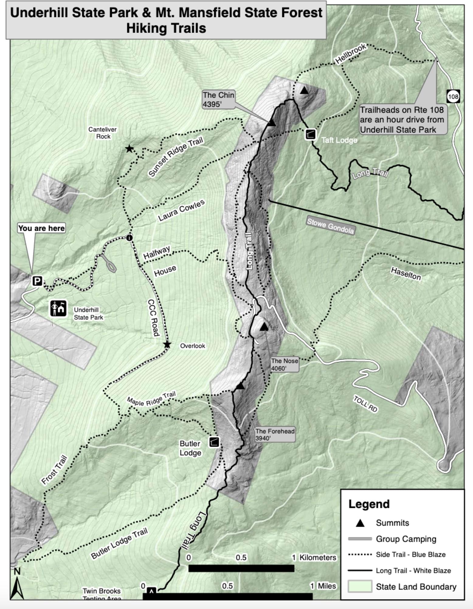
Mount Mansfield map
About this Location
One of the lesser-traveled approaches to Mount Mansfield, the hike up Maple Ridge is a strenuous climb up varied terrain. From the parking lot on Stevensville Road, hike due east along the road for 0.2 mile. Turn left at the first trail junction, and continue straight on the Frost Trail. From here, the trail climbs in earnest toward the spine of Maple Ridge. From the first rock-outcropping overlook, the hike traverses a mix of dense forest and exposed rock marked by blazes. Slightly technical spots (including “The Cut,” a narrow rock shelf, and “The Gap,” a manageable ledge jump) will keep you on your toes. Two miles into the hike, an optional 0.2-mile side trip climbs a rock scramble up to the Forehead, a broad rock outcropping viewpoint south of the Mansfield summit. This trip bypasses the detour and heads south on the Wampahoofus Trail, down-scrambling through more boulder obstacles to Butler Lodge, a cabin shelter maintained by the Green Mountain Club. The downhill return trip to the trailhead on Butler Lodge Trail is mellow compared to the ascent: a gradual singletrack trek through hardwood forest (and a leaf-peeping wonderland during peak foliage).
About Mt. Mansfield
See all hotspots at Mt. Mansfield
Mount Mansfield is the highest mountain in Vermont with a summit that peaks at 4,395 feet above sea level. The summit is located within the town of Underhill in Chittenden County; the ridgeline, including some secondary peaks, extends into the town of Stowe in Lamoille County, and the mountain’s flanks also reach into the town of Cambridge.
When viewed from the east or west, this mountain has the appearance of a (quite elongated) human profile, with a distinct forehead, nose, lips, chin, and Adam’s apple. These features are most distinct when viewed from the east; unlike most human faces, the chin is the highest point.
Mount Mansfield is one of three spots in Vermont where true alpine tundra survives from the Ice Ages. A few acres exist on Camel’s Hump and Mount Abraham nearby and to the south, but Mount Mansfield’s summit still holds about 200 acres. In 1980, the Mount Mansfield Natural Area was designated as a National Natural Landmark by the National Park Service.
Located in Mount Mansfield State Forest, the mountain is used for various recreational and commercial purposes. “The Nose” is home to transmitter towers for a number of regional radio and TV stations. There are many hiking trails, including the Long Trail which traverses the main ridgeline. In addition, the east flank of the mountain is used by the Stowe Mountain Resort for winter skiing. A popular tourist activity is to take the 4.5-mile toll road (a steep, mostly unpaved road with several hairpin turns) from the Stowe Base Lodge to “The Nose” and then hike along the ridge to “The Chin.”
Features
Restrooms on site
Wheelchair accessible trail
Entrance fee
Content from Official Website, Mt. Mansfield Official Website, Vermont eBird checklist reviewers, and Wikipedia
Last updated October 14, 2023
