Bitter Lake NWR
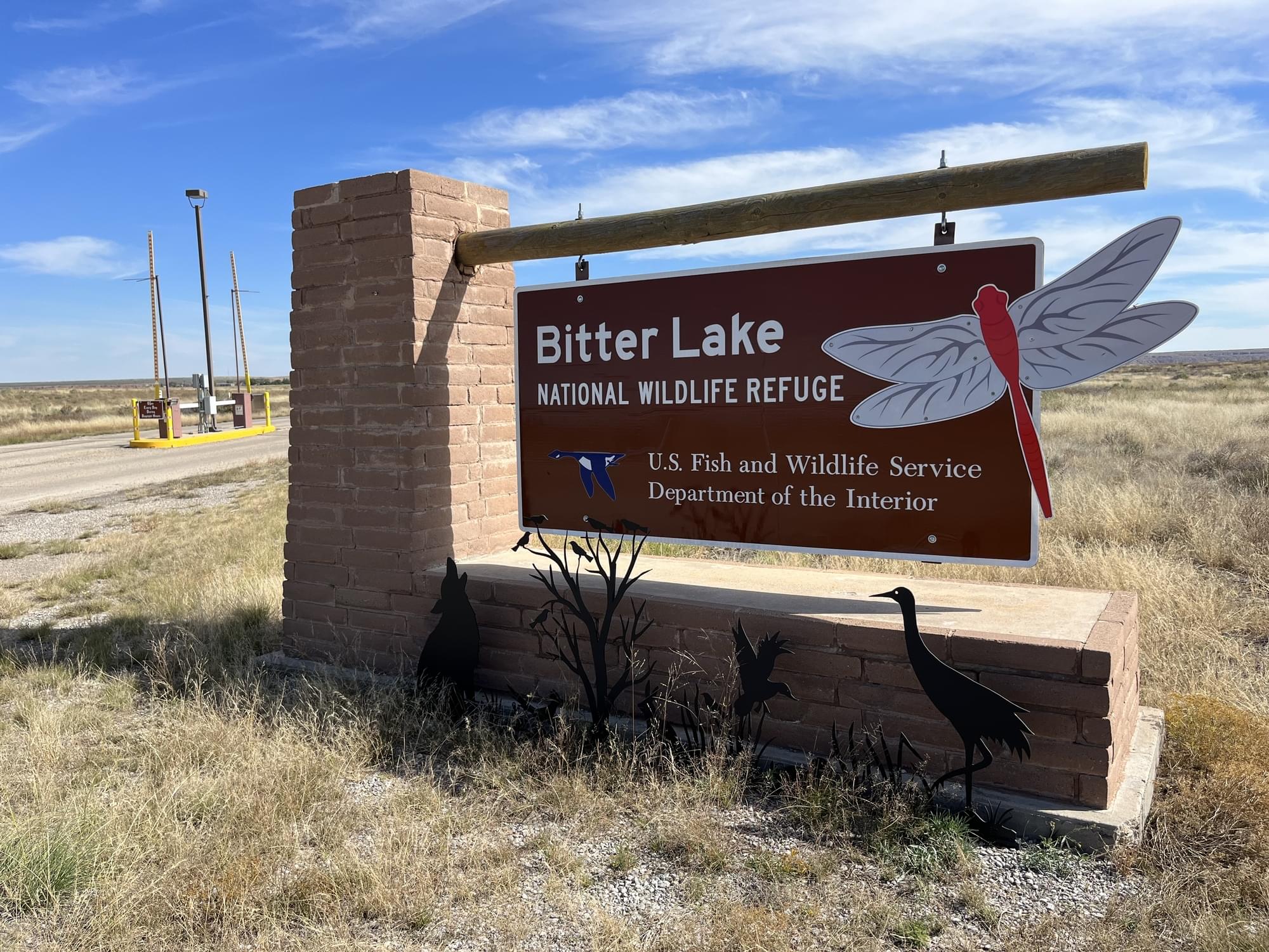
Bitter Lake NWR
Important Bird Area Roswell, New Mexico 88201
Bitter Lake National Wildlife Refuge Official WebsiteBitter Lake National Wildlife Refuge Important Bird Area webpage
Friends of Bitter Lake National Wildlife Refuge webpage
Bitter Lake National Wildlife Refuge map
Tips for Birding
Use the general hotspot for the refuge to report your observations if you are not going to be specific with respect to where on the refuge you encountered birds. It is much easier to list all your birds for this single hotspot than to prepare multiple lists when you have, for example, driven the entire tour loop. Using this hotspot for your list avoids the confusion which would result from mistakenly listing particular species (or the number of individuals) at more-specific refuge hotspots where, in fact, they did not occur.
However, for example, if you simply wandered around the Visitor Center area, recording sightings specifically for the Visitor Center hotspot would be more informative to researchers and other birders than recording for the general Bitter Lake NWR hotspot. Likewise, should you be willing to keep track of where your observations occur across multiple locations, relative to the specific eBird hotspots on the refuge, this data can be quite helpful to other eBird users (or maybe yourself at a future date). This, of course, requires a familiarity with the location and extent of Refuge hotspots, help with which is precisely one of the purposes of this website.
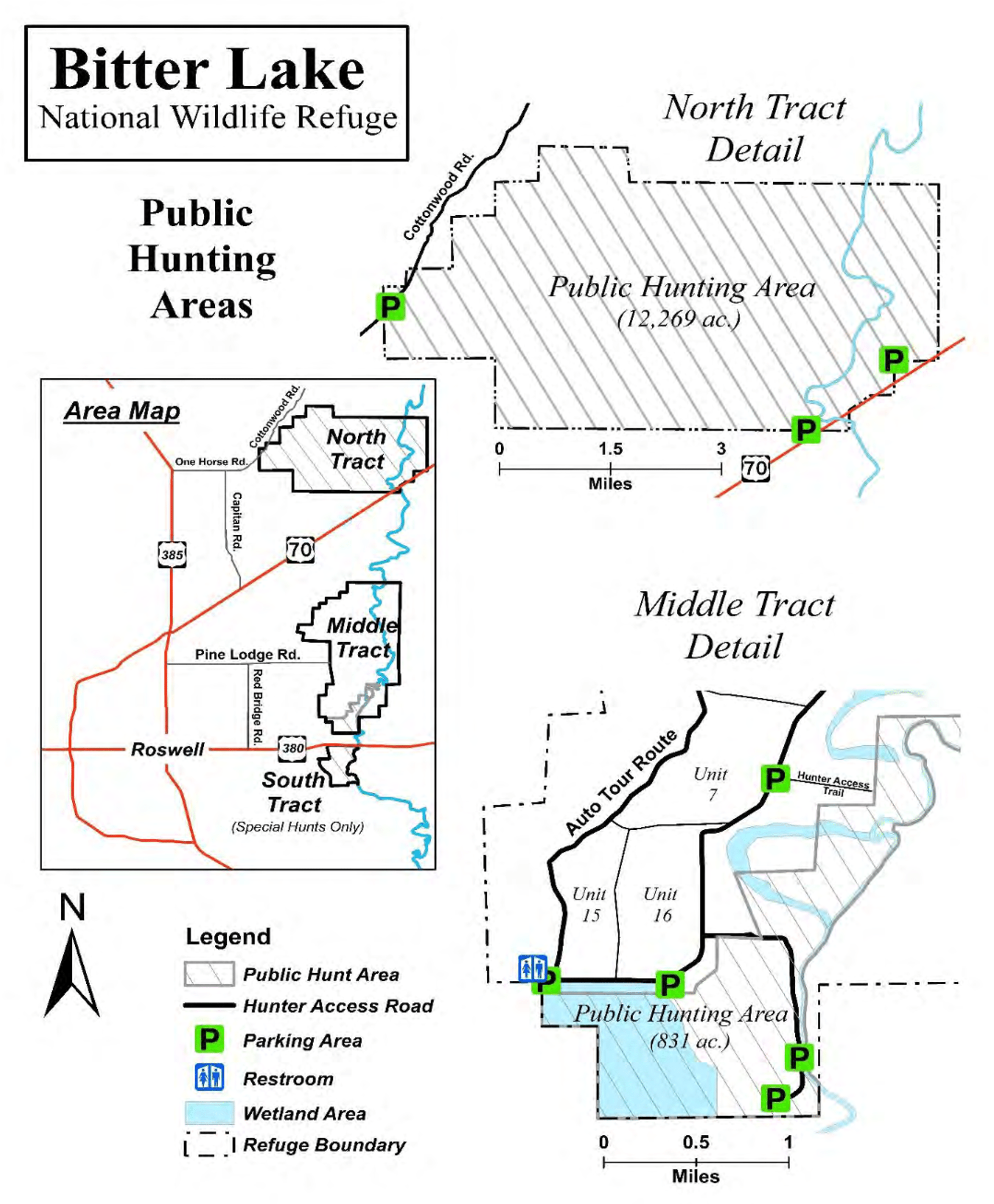
There are 8 more-specific hotspots throughout the Refuge, which includes three distinct and separate tracts of land.
One of the hotspots, the Farm, is located on the South Tract, an area historically contract farmed. This hotspot is not open to the public; very limited observations within the tract may be made from US-380 or from NM-256.
Two specific hotspots are located on the North Tract, to which no public vehicular access is allowed. The Pecos River runs north to south through the eastern portion of this tract, being joined by the ephemeral Salt Creek toward the tract’s southeast corner. The river courses thereby define three North Tract areas: (1) east of the Pecos; (2) west of the Pecos and south of Salt Creek; and (3) west of the Pecos and north of Salt Creek. The latter two areas are overlaid by an administrative differentiation, with all but a north-south strip along the west bank of the Pecos being wilderness. There is one hotspot for the area east of the Pecos, and another west of the Pecos. These two hotspots were created in 2023, so eBird species-frequency bar charts will for some time not be fully representative of species or frequency. Prior North Tract observations are undoubtedly included in the general Refuge hotspot species-frequency bar charts, though the North Tract has been only lightly birded. Noting in your “Checklist Comments” specifically where you birded would be helpful to others, or useful in reassigning your list later should the western hotspot be split.
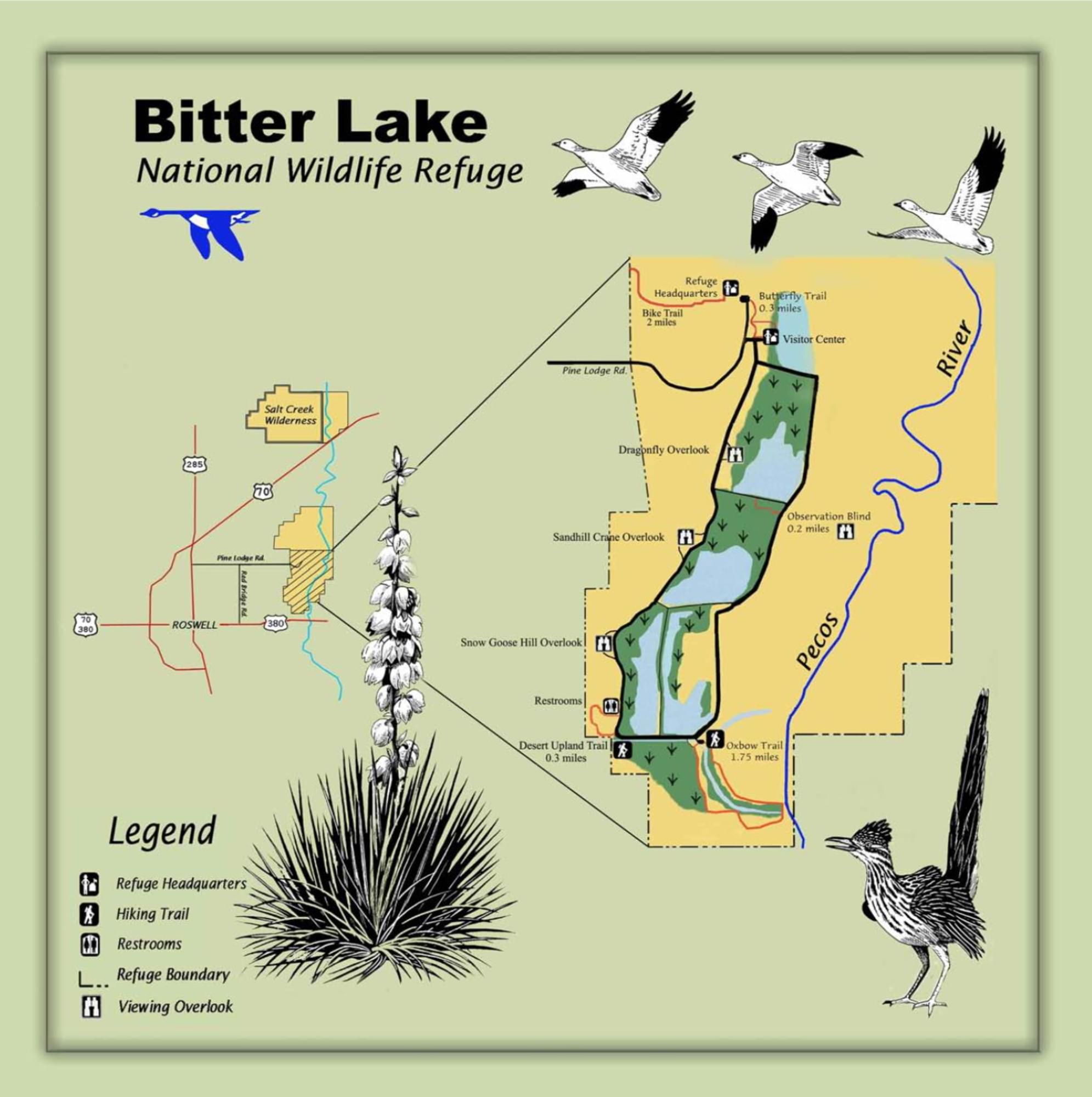
The vast majority of birders consider the Middle Tract as "the Refuge," with all 5 specific hotspots there publicly accessible via the tract’s 6.7-mile graveled auto tour loop; off-road and off-trail birding are prohibited in the Middle Tract (unlike in the North Tract). The loop, also known as Wildlife Drive and shown on some maps as Refuge Road, carries two-way traffic but is not particularly wide, so pull well off to the side should you stop. Signs announcing overlooks and trails are oriented for a counterclockwise tour of the loop. Conveniently, there are small parking areas at trailheads and overlooks, including where the specific hotspots are located. Trails that are not specific hotspots, the Dragonfly Trail, the Desert Upland Trail, and the Bike Trail, can deliver rewarding birding experiences; observations at these locations should be listed for the general Refuge hotspot, as should observations from the Goose Hill Overlook. Observations along the Butterfly (Garden) Trail, which lies between the Visitor Center and the Bike Trail parking lot, may be submitted to the Visitor Center hotspot. Staff residences and offices, including the original visitor center (now the biologist’s office) built in the 1930s, lie directly north of the Bike Trail parking lot. Mature trees in this area are definitely worth examining from the parking lot; however, public entry into the residence and office area is prohibited. The western section of the Butterfly Trail from the Visitor Center north to the Bike Trail trailhead, the Bike Trail itself (which was at one time the Refuge entrance road), and the Pájaro Observation Blind Trail are the only wheelchair-usable trails on the Refuge; plans exist to rebuild the Oxbow Trail to ADA accessibility standards. At about its midpoint, as it traverses a nearly treeless grassland, the Bike Trail offers the sole, if a somewhat distant, public view of the refuge's eponymous body of water, Bitter Lake; a spotting scope is required for the identification of all but the largest waterfowl on the lake.
The tour loop circles 4 large artificial impoundments of water, which appear as shallow lakes; from north to south, these are numbered as units 6, 7, 15, and 16 (the latter 2 being equally southernmost, with 15 west of 16). Springs on the west side of these impoundments drain toward the east, collecting in the impoundments’ southern ends; north ends tend to remain dry. The impoundment south of the loop, between the Desert Upland Trail and the Oxbow Trail, is known as Hunter Marsh. The impoundment north of the loop, below the Visitor Center, is Unit 5. Unit designations are useful for the “Details” section associated with an individual species record within your eBird list.
The only potable water and flush toilets at the Refuge are located inside the Visitor Center, with vault toilets always open at the Desert Upland Trail trailhead off the southwest corner of the auto tour loop. There are no garbage cans outside the Visitor Center nor available anywhere on the auto tour loop. Cell phone signal strength is strong at the Center, but there is no public WiFi.
During fall and winter, results of a recent Biology staff waterfowl survey may be available at the Visitor Center. A list of about 75 common species, in incomprehensible order but occasionally with photos, can be found on the Refuge website. The Watchable Wildlife brochure, also available at the Visitor Center, contains a more traditional checklist, including seasonal frequency, again of about 75 more common species; the data period from which this list was compiled is not apparent. eBird data is more complete and transparent.
The Refuge website is your best resource to begin planning a birding experience. Though the trails page (a submenu selection under “Visit Us”) does not include extensive descriptions, maps linked to that page are excellent. Note that the length given for each trail is a total length, and may include trail sections that the average birder would consider short offshoots; clicking on the “View Trail” button will take you to a map of your selected trail with each section’s length given. You may find discrepancies between the trail length listed on the lower portion of the trails page and that listed on the upper portion of the page containing the narrative trail description.
Birds of Interest
The refuge’s wetlands provide habitat for thousands of migrating Sandhill Crane, Ross's Goose, and Snow Geese, as well as for many duck species, including Northern Pintail, Mallard, Canvasback, Gadwall, Northern Shoveler, American Wigeon, Redhead, Ring-necked Duck, Lesser Scaup, Common Goldeneye, Bufflehead, Ruddy Duck, Common Merganser, Hooded Merganser, and three species of teal (Cinnamon, Green-winged and Blue-winged).
Sandhill Cranes here are mostly Lesser. Their on-Refuge number peaks in late October, after which it drops rapidly. Crane merely stop here on their way to wintering grounds elsewhere. There is no comparable spring peak; the birds evidently mostly return north by an alternate route.
About this Location
When submitting eBird observations at Bitter Lake National Wildlife Refuge, it is most helpful to start a new checklist for each hotspot within the National Wildlife Refuge. Use this general hotspot when you have a checklist that includes multiple locations or if no other hotspot or personal location is appropriate for your sightings.
About Bitter Lake National Wildlife Refuge
See all hotspots at Bitter Lake National Wildlife Refuge
Bittle Lake National Wildlife Refuge has been designated as an Important Bird Area.
Bitter Lake National Wildlife Refuge protects and provides habitat for some of New Mexico’s most rare and unusual creatures such as the least shrew, Noel’s amphipod, least tern, Pecos sunflower, and Roswell spring snail.
Located where the Chihuahuan Desert meets the Southern Plains, Bitter Lake National Wildlife Refuge is one of the more biologically significant wetland areas of the Pecos River watershed system. Established in 1937 to provide wintering habitat for migratory birds, the refuge plays a crucial role in the conservation of wetlands in the desert Southwest.
Bitter Lake is an ecological crossroad where the Chihuahuan Desert meets short grass prairie, the Pecos River, and the Roswell artesian basin. The blending of these different ecological conditions has created some unusual biological conditions. Here you will find wetland-dependent species interacting with desert creatures.
The abundant water supply draws a documented 357 species of birds to the refuge. In addition 59 species of mammals, more than 50 species of reptiles and amphibians, 24 types of fish, and more than 100 species of dragonflies and damselflies are found in this oasis.
Notable Trails
Four short trails and two longer hiking trails are adjacent to the Refuge Headquarters and Wildlife Drive.
Butterfly Trail
Near the Headquarters, this 0.25-mile trail provides interpretive information about butterflies and landscaping to attract these beautiful insects. This is a perfect location to view native vegetation.
Wildlife Drive/Auto Tour Loop
The eight-mile wildlife drive is one of the best ways to observe wildlife. Take advantage of the overlooks to get great views of flocks of Lesser sandhill cranes and Ross’ and snow geese, or to spot the coyotes and red-tail hawks crisscrossing the wetlands Drive slowly and watch for basking spiny softshell turtles, coachwhip snakes, and checkered whiptail lizards.
Oxbow Trail
About 4 miles from the Refuge headquarters office off the auto tour route, this trail used to be connected to the Pecos River. The deepwater channel is an excellent location for bird watching and is approximately two miles long.
Desert Upland Trail
This 1-mile trail takes you through an area that hosts an assortment of native plant species. Shrubs and thicket areas provide excellent quail and songbird viewing.
Dragonfly Trail
Bitter Lake National Wildlife Refuge is famous for supporting one of the most diverse populations of dragonflies and damselflies in North America. Just less than one mile on the wildlife drive, you can enjoy dragonfly watching on this trail.
The North Tract (12,160 acres) of the refuge, including the wilderness area, is open to hiking and horseback riding.
Features
Restrooms on site
Wheelchair accessible trail
Roadside viewing
Entrance fee
Content from Bitter Lake National Wildlife Refuge Official Website and John Montgomery
Last updated March 12, 2023