Focus on Birding near a County Line
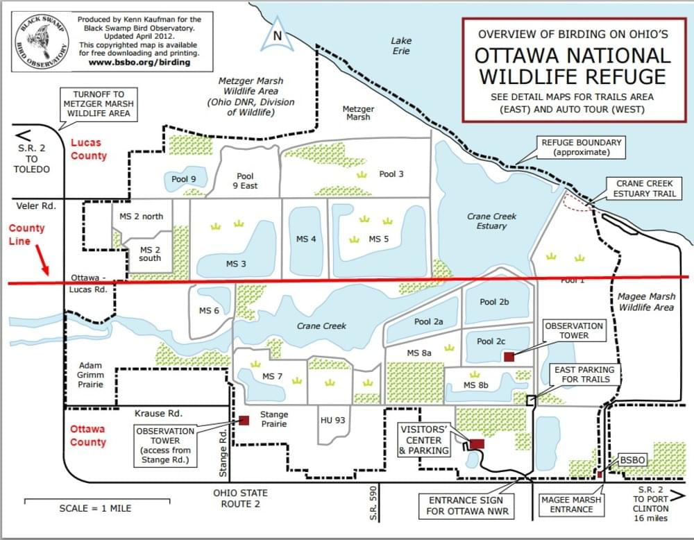 Example of a popular location with a county line.
In Ohio, there are a surprising number of parks, wildlife areas, trails, and a National Park which are located on a county line. If you carefully keep your bird records by county, it is helpful to know where the county line is located so that the birds will be assigned to the proper county.
eBirding along County, State, and Country borders
In eBird, every complete checklist should be thought of as an attempt to record everything that you can detect from where you are standing or walking. If you are standing along the banks of a river you should certainly scan the river and both of its banks. If you are along a ridgetop, you should be counting birds that you can see in all directions. However, at times there may be a geopolitical border that bisects your walking path or your field of view. Birds never have cared much about geopolitics and in many cases they freely cross borders. What is the best way to do your eBirding in cases like this?
When it comes to the position of the birder and the position of the bird, listing rules can be inconsistent. For example, the preference in Ohio is to only count birds that have demonstrably occurred within the state or county boundaries. However, most yard lists count whatever bird can be seen from your yard. eBird best practices strive to bring more consistency to lists.
How to report checklists near a state or county line in Ohio
Ohio eBird reviewers ask that birders keep precise state and county lists. When you are at a location where you see birds across a state or county line, we ask that you keep two incomplete birding lists, one for each side of the border.
When keeping separate checklists for different sides of a border, please follow these rules:
- For both checklists, the answer to “Is this a complete checklist of the birds you were able to identify?” must be “No“, because each list intentionally omits birds in the other geopolitical area.
- Use your exact location for birds detected on your side of the border; create a personal location directly across from you on the opposite side of the border for the birds you detect on that side. (You can also select an appropriate hotspot for either side of the border, but only if it accurately describes your location on your side or the general vicinity of the birds on the other side.)
- If you freely crossed back and forth across the border while birding, choose an incomplete Stationary or Traveling protocol for both checklists. If you could not freely cross the border while birding, use the “Incidental” protocol for the checklist on the inaccessible side. Do not use the Stationary or Traveling protocol for any lists plotted to counties, states, or provinces you did not actually bird within.
- We recommend focusing on one side of the border at a time instead of trying to keep two lists at once (you will not be able to keep simultaneous lists running on eBird Mobile if you are using tracks).
eBird best practices
Continue to follow eBird best practices; submit complete checklists that are short in duration and distance.
- At eBird, complete checklists come first. Complete checklists are an attempt to record everything you can see or hear from your location. We do not want birds left off your list simply because they were across an (often invisible) geopolitical boundary. If you do leave birds off for this reason, it is no longer a complete checklist!
When traveling somewhere, begin a new checklist every time you cross a border.
- This ensures the expected species list on eBird Mobile is up to date, and any new birds you detect are placed in your current county, state, and country instead of the previous one.
Every bird seen or heard from your location “counts”, regardless of where the bird is.
- A complete checklist includes birds on both sides of the border. If you are standing on the Texas side of the US-Mexico border, and you see a Lineated Woodpecker flying on the Mexico side, report it! In eBird, this observation “counts” for where you are standing (i.e., your US and Texas lists). In Ohio, we ask that you use two incomplete checklists in these circumstances so that birds are assigned to the correct state and county.
Plot your location as accurately and precisely as possible.
- For complete checklists, always plot your checklist where you were, not where the birds were. Do not place a complete checklist anywhere you did not stand or travel during that list.
- Your data will be summarized to a single county, state, and country based on where you plot your checklist – so be precise! Avoid using hotspots if they do not accurately represent your location for the entire checklist.
Any time you see or hear a rare bird across a border, add some notes in the Species Comments about the bird’s location.
- From the example above: because Lineated Woodpecker does not have a confirmed record within the United States, if you see or hear one in Mexico while you are on the Texas side of the border, you would certainly be asked to provide notes about this rare observation. Write detailed comments to help other birders understand the exact location of the bird relative to your own. This is especially helpful for those that might use the data, including journals and Bird Record Committees
Geopolitical units give us a way to organize and summarize eBird observations. Any birds you report on a checklist, regardless of where or how far you travel, will be automatically assigned to a county (where applicable), state/province, and country based on where you plot your list.
In most cases, this also determines the data entry checklist and data quality filter. Your checklist can only use one eBird filter, so there may be mismatches in species data if you include birds from multiple geopolitical areas on the same checklist, especially when those areas have considerably different habitats and birds.
These issues can be avoided by doing all of the following, in addition to the instructions above:
- keep your checklists short in distance and duration
- plot your location as precisely as possible
- start a new checklist every time you cross a geopolitical boundary while traveling
These steps ensure your checklist is assigned to the correct eBird filter and summarized in the appropriate county, state, and country.
From eBird help article Birding Along Borders