Thomas and Palmer Brook, Great Barrington
Thomas and Palmer Brook, Great Barrington
Berkshire Natural Resources Council 305 State Road Great Barrington, Massachusetts 01230
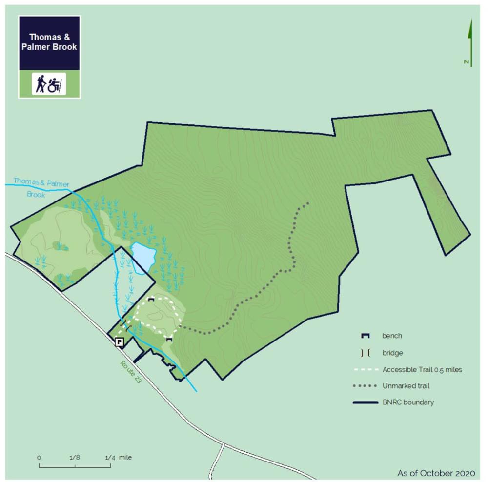
Official WebsiteThomas and Palmer Brook map
Tips for Birding
The meadow loop is a short but lovely birding hike, roughly half a mile. People often walk their dogs here, and more often than not tend to ignore the "dogs must be on a leash" sign posted at the front. Hiking the woodlands trail is a bit more strenuous with some mild elevation gain, but this area is much less frequented than the front meadow area.
Birds of Interest
Great Blue Heron, Green Heron, Wood Duck, Willow Flycatcher, Belted Kingfisher, Swamp Sparrow
About this Location
The 219 acres of the Thomas and Palmer Brook reserve slope upward from the brook through an old pasture, a wetland, and mature forest to a dramatic high point of exposed bedrock. An accessible trail through the meadow leads into the forest and winds past boulders and large sugar maple trees. A habitat restoration project removed invasive species in the apple orchard and surrounding area.
This land, and all of the present-day Berkshires, are the ancestral homeland of the Mohican people who were forcefully displaced to Wisconsin by European colonization. These lands continue to be of great significance to the Stockbridge-Munsee Mohican Nation today.
The Thomas and Palmer Reserve, established in 2015, is on the southwestern slope of the Threemile Hill ridge that is a backdrop to much of Great Barrington’s commercial activity. The property is part of a habitat corridor reaching from Monument Mountain Reservation, Housatonic Flats, and Fountain Pond State Park in the west to the Butternut Ski Area and Beartown State Forest in the east. Keeping the entire contiguous corridor protected is important for wildlife and climate resiliency. Much of the land comprising the reserve was farmed well into the last century.
BNRC envisions the site as an anchor for future conservation along the Threemile Hill ridge, and for connected routes for hiking as part of The High Road. The High Road will connect trails and conservation to towns throughout the Berkshires.
The old pasture is now dense with pollinator-loving goldenrod and milkweed. The forest consists of mixed hardwoods, white pine, and hemlock. Beaver activity is visible near the brook and wetland. Birds that have been attracted by the property’s diverse habitats include the American woodcock, the blue-winged warbler, the chestnut-sided warbler, the eastern towhee, and the purple finch. The property offers excellent conditions for wood turtles. The Thomas and Palmer Brook corridor has been identified as a core habitat by Natural Heritage, meaning it is a habitat that could have rare, vulnerable, or uncommon mammals, birds, reptiles, amphibians, fish, invertebrates, and plant species.
Like the Berkshire Natural Resources Council’s nearby Housatonic Flats property, the reserve is easily accessible from downtown Great Barrington. From the trailhead, the path crosses the bridge that spans Thomas & Palmer Brook, a tributary of the Housatonic River.
Notable Trails
Thomas and Palmer Brook Trail
Trail: 0.5 miles, round-trip
The trail descends into a meadow where hikers can choose which direction to take on the loop trail. Heading counter-clockwise the trail winds you along the woodland edge and through the forest. It continues around a knoll that is an old apple orchard. On the westerly side of the knoll, the path crosses between two large sugar maples and two large boulders before emerging back into the meadow.
Along the way enjoy multiple places to rest and take in the expansive view of the wetland complex.
An unmarked wood road connects to the east side of the accessible trail and winds you through the upland forest.
The AllTrails website has a description and map of a hike at Thomas and Palmer Brook.
Features
Restrooms on site
Wheelchair accessible trail
Entrance fee
Content from Official Website and Paul Seaman
Last updated November 25, 2023