Mt. Lemmon--Control Road-upper
Mt. Lemmon--Control Road-upper
Coronado National Forest Mt. Lemmon, Arizona 85619
Official WebsiteControl Road Scenic Drive map
Mount Lemmon Attraction Guide
Things to Do on Mount Lemmon
About this Location
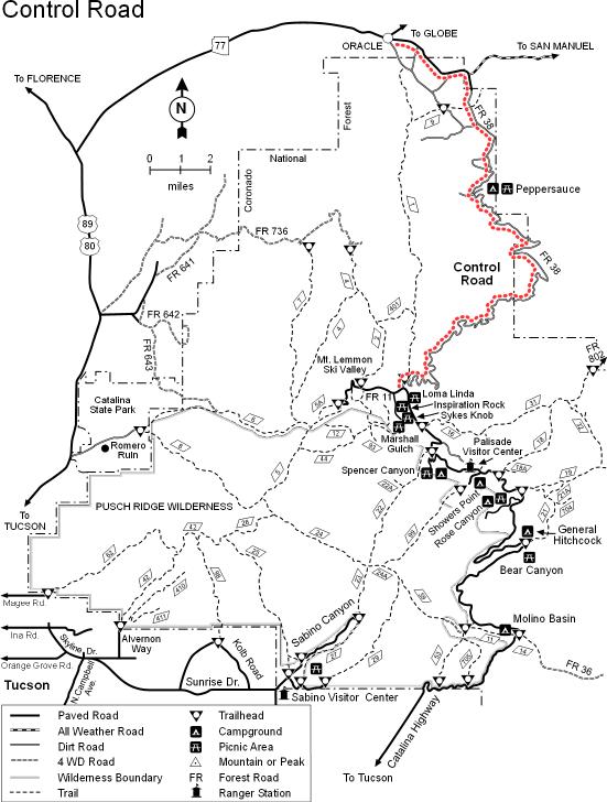
This rough, winding road that snakes up the northeastern slopes of the Santa Catalinas was the first major access route built to the upper reaches of the Santa Catalina Mountains. While some residents refer to the road as the Old Mt. Lemmon Highway, the name “Control Road” is as old as the route itself. When this was the only road up the mountain, it was so narrow in some places that, if two cars met going in opposite directions, they would be unable to pass. The only way to avoid total gridlock was to “control” the road by making its narrow upper segment a one-way road on which the direction of travel was switched at regular intervals. Though the Control Road has been replaced by the paved Catalina Highway as the major access route to the mountain top, it still serves as a popular sightseeing route for those willing to brave a little rough driving. (It’s been made a little wider, too.) In addition to the fact it is not paved, the Control Road differs from the Catalina Highway in another significant way. The highway and most of the trails that scale the Santa Catalinas are concentrated on the range’s southwestern slopes. The Control Road winds down Mt. Lemmon’s northeastern shoulder, offering a different perspective on the mountain and its surroundings. If you approach the old road via the Catalina Highway, it drops off a high ridge just north of the Loma Linda Picnic Area. As it winds its way down the mountain, through an area of old mines and ranches, the road provides broad overlooks of the grassy, oak-covered foothills to the east. In the distance, the San Pedro Valley stretches to the Galiuro Range. Farther in the distance, the upper slopes of the Pinaleño Mountains and their northern neighbors, the Santa Teresas, are visible through low passes in the Galiuros. The stacks and tailings ponds of the copper smelter at San Manuel complete the panorama.
From the town of Oracle, follow The Old Mt. Lemmon Road to the Forest boundary where it becomes FR-38 and continues up the mountain. From Tucson, follow the Catalina Highway to milepost 24.5, just beyond the Loma Linda Picnic Area, and turn right (northeast) onto FR-38. Follow FR-38 (the Control Road) straight past the Mt. Lemmon Fire Station and a road that forks to the right and continues down the mountain But can be snow-covered and impassable in winter.
About Mt. Lemmon
See all hotspots at Mt. Lemmon
Approximately an hour's drive from Tucson's city center, Mount Lemmon is a favorite day trip and camping spot for Tucsonans. It's a beautiful outdoor escape, ideal for hiking, biking, rock climbing, picnicking, sunset watching, sledding, and skiing.
Mount Lemmon is usually 20-30 degrees cooler than Tucson, so you can find cooler temperatures there in the summer and a beautiful layer of snow in the winter, along with vibrantly colored leaves in autumn.
With a summit of 9,159 feet, Mount Lemmon is the highest point in the Santa Catalina Mountains. The mountain was named for botanist Sara Plummer Lemmon, who trekked to the top of the mountain by horse and foot in 1881.
Mount Lemmon is a peak in the Catalina mountain range, surrounded by Coronado National Forest.
To reach Mount Lemmon from Tucson, turn off Tanque Verde Road onto Catalina Highway. Take Catalina Highway as far up the mountain as you desire to go!
On your way up the mountain, you may want to stop at Windy Point Vista (Mile Marker 14). This popular lookout point has bathrooms and is a terrific spot for photos.
Note that the road up the mountain is curvy with very few straight sections. If you or anyone in your car is prone to motion sickness, plan ahead by bringing bags, mints, cold water, snacks, or stomach-settling medications. It also helps to not drive on an empty stomach.
Take Catalina Highway northeast from Tanque Verde Road. For desert and mountain species, stop at picnic and campgrounds (Molina Basin, Bear Canyon, Rose Canyon Lake, and others) as you drive the narrow, winding road to high elevations.
Content from Official Website, Mount Lemmon Attraction Guide, and Tucson Audubon Society