Fort Cavazos--Four Corners area (Limited access)
Fort Cavazos--Four Corners area (Limited access)
Fort Cavazos, Texas 76544
Official WebsiteInstallation pass information
Tips for Birding
A pass is required - See "About this location" for details
Black-capped Vireos can be found in many areas of this hotspot region from late March through late September. This is a less productive region for finding Golden-cheeked Warblers in, but there are some adequate habitat patches scattered throughout. Do NOT pin specific locations for these sensitive species, or use any audio playback from March through September.
The extensive network of ponds, huge grasslands, and rich riparian forests along 3 permanent creeks make this one of our most species-diverse hotspot regions. The western position and many of the habitat types encourage many sporadic or locally uncommon western species to show up in Fall-Winter, such as Rock Wren, Burrowing and Short-eared Owls, Sage Thrashers, and Longspurs. Meanwhile the riparian forests attract eastern birds during Spring, some of which stick around to breed such as Louisiana Waterthrush and Acadian Flycatcher.
Birds of Interest
- Golden-cheeked Warbler
- Black-capped Vireo
- Migration stopover
- Winter rarities
About this Location
This is an active-duty military installation with a law enforcement team patrolling the training areas. It is absolutely imperative that visitors follow all regulations exactly. Regulations can be found at cavazos.isportsman.net.
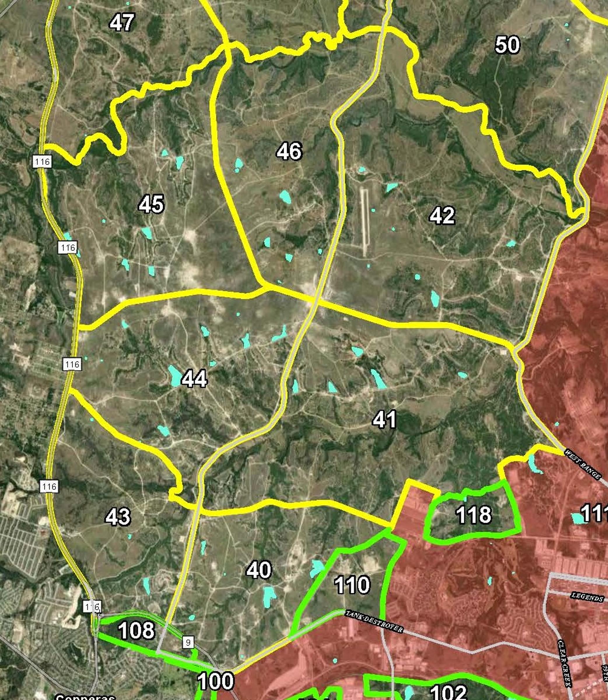
For security reasons, Fort Cavazos hotspots are designed as regions covering large areas rather than specific locations. This hotspot should be used when birding in Training Areas 40 through 46, or FH area 118. Training Areas 47 and 48 may be included on this hotspot or Fort Cavazos--West Range Central (Limited access).
- A general recreation permit is required, and may be purchased for $5 from the iSportsman web portal.
- A vehicle range pass must be displayed in the windshield/dash.
- An installation pass is required, and may be obtained at the Visitor Welcome Center.
- Each Training Area must be checked in and out of via the iSporstman web portal.
- Road birding is ONLY allowed with the appropriate passes and if the birder is checked in to the relevant TA.
- Training areas are only open to birders under limited circumstances, and may close on very short notice.
- General recreation option is not available from September 30, 2023- January 31, 2024.
Notable Trails
No officially designated recreation trails, but many trails made by Army maneuvering may be used by recreators. Vehicles may only be driven on permanent roads and vehicle trails. Off-roading is prohibited. There are many trails or sections of trails which may be legally accessed but are impassable for most vehicles and drivers. Foot travel has few restrictions within the designated Training Areas.
Some notable drivable trails are:
- TA 41 - End points on Georgetown Road View Map and Elijah RoadView Map. House Creek and numerous ponds are accessible from this trail. Predominantly grassland and upland oak savannah
- TA 42 - End points on Georgetown View Map and West RangeView Map roads. Follows the Cowhouse Creek riparian plain. Predominantly grassland, with access to multiple riparian forest types.
- TA 44 - From near the intersection of Georgetown and Elijah roadsView Map to near the western edge of the installationView Map. Provides very easy access to numerous ponds. Predominantly grassland.
- FH 118 - A short trail runs from the southernmost section of Georgetown RoadView Map to the top of the small mesa. The upper portion is very difficult to drive, and there are no good spots to turn a vehicle around. The trail goes through a patch of oak-juniper forest, and leads to oak scrubland.
Features
Wheelchair accessible trail
Entrance fee
Roadside viewing
Restrooms on site
Content from Dayna
Last updated November 2, 2023