Mt. Lemmon--Oracle Ridge Trail
Mt. Lemmon--Oracle Ridge Trail
Coronado National Forest Mount Lemmon, Arizona 85619
Official WebsiteOracle Ridge Trail map
Mount Lemmon Attraction Guide
Things to Do on Mount Lemmon
About this Location
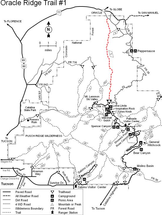
This trail is listed as #1 for some very good reasons. First, it follows one of the earliest known routes to the top of Mt. Lemmon. Second, it is believed to be the trail that John and Sara Lemmon followed, in the early 1880s, on their trip to the summit of the mountain which was later named in Sara’s honor. This trail is reportedly where biologist Lemmon saw his first Arizona pine. Actually a subspecies or variety of ponderosa pine, this was the first of roughly 100 plant species and subspecies Lemmon cataloged in the state’s southern mountains. In spite of the fact that the Oracle Ridge Trail has been traveled for so long a time, it is quite hard to follow in a number of places. One reason is that the area through which it passes has long been a center of mining and prospecting activity. As a result, old mining roads and bulldozer paths have obscured the trail in several places. If you’re a history buff, you’ll appreciate the old and not-so-old mines you encounter along this route. If your interests tend toward more natural sights, you’ll probably spend more time taking in the views which stretch to the north, east, and west. The Oracle Ridge Trail passes very near the summit of Rice Peak and relatively near the summit of Apache Peak. These promontories offer good views of Mt. Lemmon and the Santa Catalinas, as well as of the historic mining district around the town of Oracle and the basin and range landscape beyond.
From Tucson: Take the Catalina Highway off Tanque Verde Road. Drive 4.2 miles to the Forest boundary and continue 25 miles to a point past the Loma Linda Picnic Area, where the Control Road (FR 38) turns right and passes the Mt. Lemmon Fire Station. Follow this road straight, past the fire station and down the ridge. Just beyond the first cattle guard, the trail leaves a parking area on the left side of the road and cuts through a notch in the ridge. From Oracle: Follow the Oracle Highway through the town of Oracle to the Old Mt. Lemmon Road (also called the Control Road and FR 38). Follow this route south at a fork where signs point the way to the YMCA Camp and Boys Camp. It’s about 1 mile on this all-weather dirt road to the trailhead marked “Arizona Trail” near a corral on the right side of the road. Use Cody Trail #9 (part of the Arizona Trail) to gain access to the Oracle Ridge Trail.
About Mt. Lemmon
See all hotspots at Mt. Lemmon
Approximately an hour's drive from Tucson's city center, Mount Lemmon is a favorite day trip and camping spot for Tucsonans. It's a beautiful outdoor escape, ideal for hiking, biking, rock climbing, picnicking, sunset watching, sledding, and skiing.
Mount Lemmon is usually 20-30 degrees cooler than Tucson, so you can find cooler temperatures there in the summer and a beautiful layer of snow in the winter, along with vibrantly colored leaves in autumn.
With a summit of 9,159 feet, Mount Lemmon is the highest point in the Santa Catalina Mountains. The mountain was named for botanist Sara Plummer Lemmon, who trekked to the top of the mountain by horse and foot in 1881.
Mount Lemmon is a peak in the Catalina mountain range, surrounded by Coronado National Forest.
To reach Mount Lemmon from Tucson, turn off Tanque Verde Road onto Catalina Highway. Take Catalina Highway as far up the mountain as you desire to go!
On your way up the mountain, you may want to stop at Windy Point Vista (Mile Marker 14). This popular lookout point has bathrooms and is a terrific spot for photos.
Note that the road up the mountain is curvy with very few straight sections. If you or anyone in your car is prone to motion sickness, plan ahead by bringing bags, mints, cold water, snacks, or stomach-settling medications. It also helps to not drive on an empty stomach.
Take Catalina Highway northeast from Tanque Verde Road. For desert and mountain species, stop at picnic and campgrounds (Molina Basin, Bear Canyon, Rose Canyon Lake, and others) as you drive the narrow, winding road to high elevations.
Content from Official Website, Mount Lemmon Attraction Guide, and Tucson Audubon Society