Los Padres NF--Wagon Caves & oak savanna
Tips for Birding
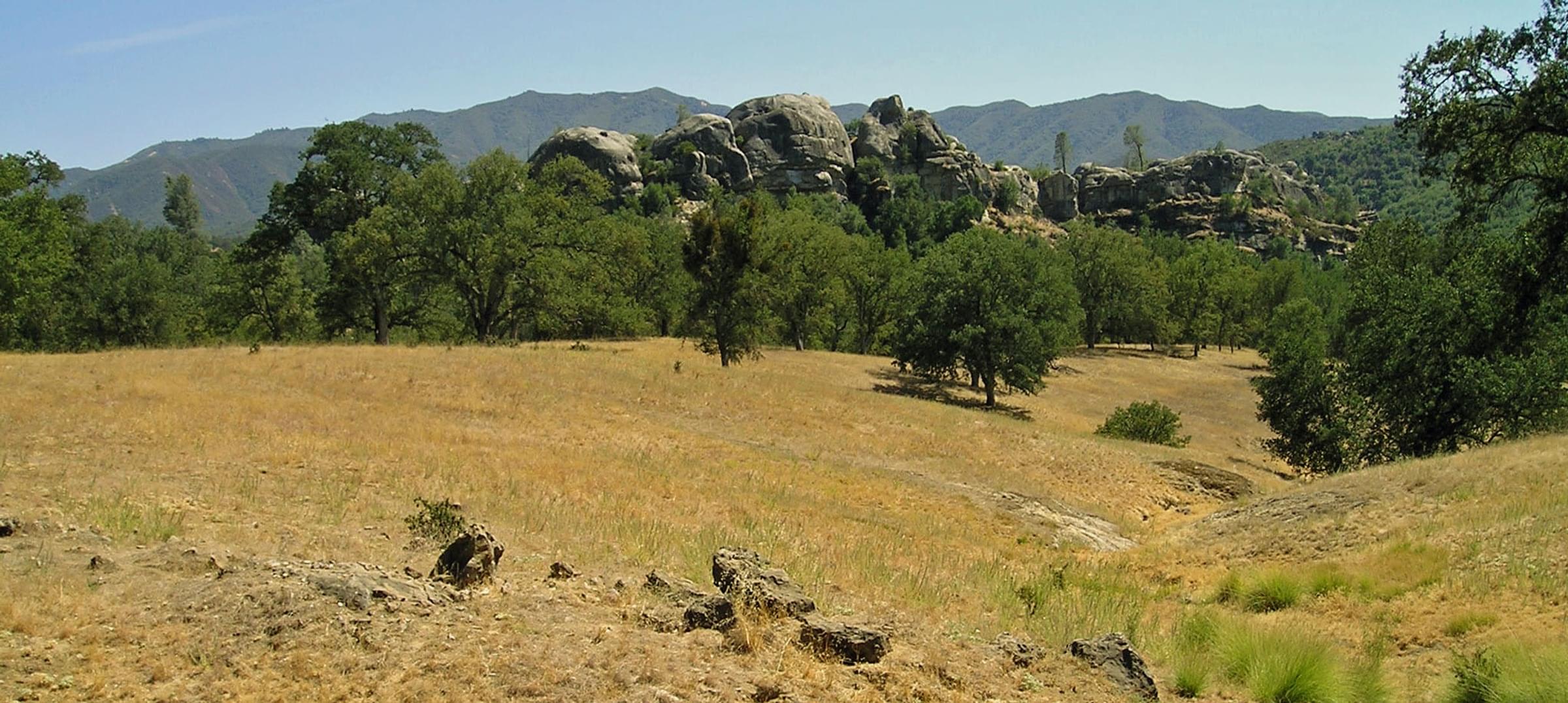
The Wagon Caves area is a beautiful locale in the Los Padres National Forest. Details of access are set out in "about this location," below. The Hotspot is within The Indians section of Los Padres National Forest, characterized by huge boulders and rock formations. At the National Forest boundary the paved road narrows and becomes Indians Road (at least on most maps; some call it Milipitas Road). This Hotspot encompasses gorgeous oak savanna habitat for the first 3 miles of Indians Road, including the Wagon Caves area (on your left, just a half-mile beyond the National Forest border, where there is a large parking area and a stile in a fence to trails through the Indian Caves rocks). Beyond the Wagon Caves, dirt roads, numbered 4 through 7, go left and provide loops where 'rough' camping is permitted and one has views over the north fork of the San Antonio River below (rough trails reach the river). Or one can simply bird the oak savanna, gawk at the wildflowers in spring, and clamber about on huge boulders along the way. That 3 mile stretch of Indians Road goes from 1500' (455m) to 1800' (550m) elevation.
Although The Indians is a remote area, about 100 miles (3 hours) away from the Monterey Peninsula, it is popular to some campers, hikers, wildflower lovers, fisherman, and hunters (in deer or pigeon seasons), and it can feel "crowded" on good-weathers weekends in spring, summer, or early autumn.
This Hotspot begins at the border of the Los Padres National Forest, as the public does not have access to the Fort Hunter Liggett oak savanna en route. Do not enter casual observations made while driving through Fort Hunter Liggett in this Hotspot (instead, create personal locations for such casual obs). This Hotspot ends where Indians Road crosses a creek via a narrow one-way bridge, and then immediately goes over a cattle guard. At that point, you enter a different habitat going up a dramatic rocky canyon, in a Hotspot called "Los Padres NF--upper Indians Road to summit vicinity (above oak savanna)."
Birds of Interest
Residents of the oak savanna include California Quail, Wild Turkey, Band-tailed Pigeon, Acorn and Nuttall's Woodpeckers, Oak Titmouse, Western Bluebird, Purple Finch, Lark Sparrow, and a small but conspicuous population of Yellow-billed Magpie. Canyon and Rock Wrens inhabit Wagon Caves and other rock formations; Bewick's Wren is resident in brushy areas, and House Wrens abound as breeders in summer. Raptors can be numerous, including breeding Prairie Falcon (scarce). In spring and summer, creekside riparian birds can include Black-chinned Hummingbird (scarce compared to resident Anna's), Pacific-slope and Ash-throated Flycatchers, Warbling Vireo, Yellow and Wilson's Warblers, Black-headed Grosbeak, and Lazuli Bunting.
About this Location
To the public "the Wagon Caves area is great for exploring, and has loads of shallow caves and cool rock formations, including one large cave (large enough for a wagon to shelter under… hence the name of the area). Wagon Cave has been a major landmark in the central Monterey Ranger District and means many things to many people. It is a place of great importance to the Salinan Indians. It is a place where many have fond childhood memories of camping." The Wagon Caves are within a larger area in the Monterey County portion of this National Forest which locals call The Indians. This area lies below the Ponderosa Pine forests of Memorial Park vicinity.
This remote area is reached via Del Venturi Road in Fort Hunter Liggett in southwester Monterey County. Fort Hunter Liggett is an Army and National Guard training area with many limitations, including rules that forbid leaving the public roads. Around the Fort's cantonment area, follow the signs to Del Venturi Road with access to Memorial Park. One drives on a paved road through miles of gorgeous Valley Oak savanna, and crosses the north fork on the San Antonio River in a 'wet' crossing on concrete twice, before reaching the well sign-posted border of Los Padres National Forest. [Rarely, in some springs after exceptional winter rains, Del Venturi Road will be closed at the river crossings by high water flow, and tourist are re-routed up Mission Creek and Milipitas Roads, which are wide dirt roads, to detour back to Del Venturi Road above those water crossings.] Once you reach the National Forest you can stop and bird as much as you like -- one may get a feeling of freedom of reaching that border, as you were not permitted to step outside your car when within Fort Hunter Liggett.
Back in the 2oth century, one could also access Memorial Park and Indians Road via a narrow, winding, rough dirt and gravel road following the Arroyo Seco River upstream into Los Padres National Forest. That road still exists, but it has been closed to vehicular traffic for some decades, but can be used to hikers and bicyclists.
Features
Roadside viewing
Restrooms on site
Wheelchair accessible trail
Entrance fee
Content from Don Roberson
Last updated May 15, 2023