Hopkins Memorial Forest, Williamstown
Hopkins Memorial Forest, Williamstown
Williams College Center for Environmental Studies Northwest Hill Road Williamstown, Massachusetts 01267
Hopkins Memorial Forest Official WebsiteHopkins Memorial Forest map
About this Location
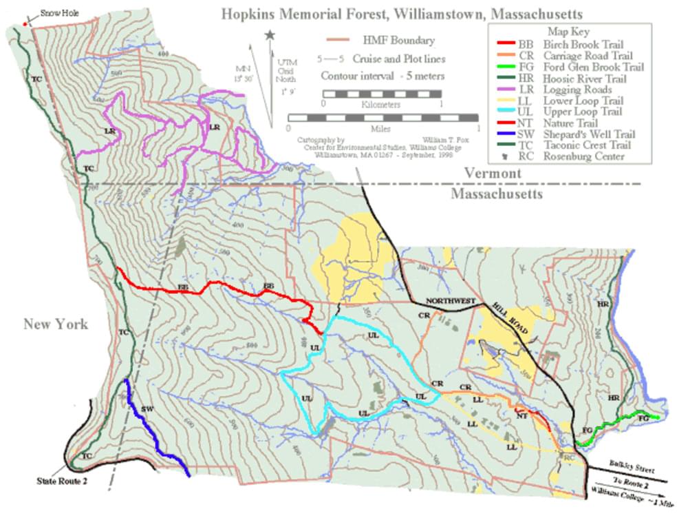
Hopkins Forest (HMF) contains about 12 miles of trails open to the public for walking, skiing, and snowshoeing. Horseback riding is allowed only on the Ford Glen Brook and Carriage Road trails. All wheeled and motorized vehicles, including bicycles, are prohibited in the HMF.
About Hopkins Memorial Forest
See all hotspots at Hopkins Memorial Forest
The Hopkins Memorial Forest (HMF) is a 2600-acre (1040 ha) reserve in Massachusetts, New York, and Vermont managed by the Williams College Center for Environmental Studies (CES) to facilitate research and undergraduate teaching activities while preserving and monitoring forest resources, particularly through long-term ecological research. We strongly encourage disciplinary and interdisciplinary teaching, scholarly activity, and experimental research in the Forest. Low-impact recreational activities that foster an understanding and enjoyment of the forest environment are encouraged.
The vision for the HMF of the future is a better-understood landscape that will continue to provide opportunities for learning and connection with the natural world.
Notable Trails
Birch Brook Trail|
The BBT leaves the Upper Loop Trail near a bridge across the North Branch of Birch Brook. The trail climbs the steep, east-facing slope of the Taconic Range, crossing the New York state border at 1.1 miles and reaching the Taconic Crest Trail 1.5 miles from the Loop Trail.
Carriage Road Trail
The CRT (1.4 miles), also known as the Horse Trail, follows the alignment of the Buxton Farm carriage road running between the Rosenburg Center at the eastern HMF entrance and the northern reaches of NW Hill Road.
Ford Glen Brook Trail
The FGBT parallels Ford Glen Brook between the Hoosic River and Northwest Hill Road. The eastern half of this 0.6-mile-long trail is on private property.
Hoosic River Tail
The mile-long HRT parallels the Hoosic River along the eastern boundary of the HMF. The HRT starts at the old Boy’s Club Camp field on the FGT and ends at the northeastern corner of the Forest.
Lower Loop Trail
The LL forms a loop of about 1.5 miles immediately west of the Rosenburg Center at the main entrance to the HMF. The northern leg of the trail is on the old carriage road, while the southern leg parallels an old farm road and has a fairly steep section just west of the Moon Barn.
Upper Loop Trail
The 2.6-mile UL is the western loop of a figure-eight formed with the LL. The trail cross rolling terrain and can be hiked in less than two hours.
Shepherd’s Well Trail.
The SWT (1.0 mile) connects the Taconic Crest Trail with the western upper reaches of the RRR Brooks Trail (that ends on Bee Hill Road at Flora Glen in Williamstown).
Taconic Crest Trail
The TCT extends from Pittsfield, MA to N. Pownal, VT, and is marked with white blazes. The Trail runs near the western border of the HMF. The easiest access to the Trail is from Petersburg Pass on MA-2. The Trail enters Hopkins Forest immediately north of the Pass, reaching the SWT at 0.4 miles and the BBT at 1.0 miles from Petersburg Pass. About 0.5 miles north of this intersection, the TC trail enters Vermont, and 2.75 miles from Petersburg Pass a short trail leads east to the Snow Hole.
The AllTrails website has descriptions and maps of hikes at Hopkins Memorial Forest
Features
Restrooms on site
Wheelchair accessible trail
Entrance fee
Content from Hopkins Memorial Forest Official Website and Additional information on this and other trails is available in the Northern Berkshire Outdoor Guide, published by the Williams Outing Club.
Last updated November 24, 2023