Red Hill Conservation Area, Moultonborough/Sandwich
Red Hill Conservation Area, Moultonborough/Sandwich
Red Hill Road Moultonborough, New Hampshire 03254
Official WebsiteRed Hill Conservation Area map
About this Location
Since the 19th century, Red Hill (elevation 2,030 feet) has been noted for its panoramic views of Lake Winnipesaukee, Squam Lake, and the White Mountains. Today, Red Hill is one of the major conservation landmarks in New Hampshire’s Lakes Region.
The summit and slopes of Red Hill are protected as part of LRCT’s 2,650-acre Red Hill Conservation Area.
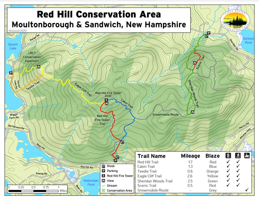
Alongside the Squam Lakes Association, Squam Lakes Conservation Society, Lake Kanasatka Association, Squam Lakes Natural Science Center, Society for the Protection of New Hampshire Forests, Moultonborough Snowmobile Club, and faculty and students of Moultonborough Schools, we can maintain 6.2 miles of trails for hiking and snowshoeing, as well as over 3 miles of trail for snowmobiling.
Hiking on these trails in any season provides ample opportunity to view the spectacular wildlife and over 200 years of human settlement and recreation in this area. Most famous is the view from the summit and fire tower, which have been incorporated into the National Historic Lookout Register since 2003. Visitors can also appreciate the interesting geological activity that has allowed mountains such as this to form all across the Lakes Region.
Notable Trails
Red Hill (Fire Tower) Trail 1.75 mi. Moderate Hike Elevation Gain: 1,286 ft.
This is the main trail for hikers summiting Red Hill, along the south side of the mountain to the summit. Hikers will pass by the historic remains of the Horne family homestead on their way to the summit, which provides excellent views of Squam Lake and Lake Winnipesaukee, as well as the Squam, Belknap, Ossipee, and White Mountain ranges. This is an excellent hike for any time of the year, with an exceptional view atop the fire tower.
Cabin Trail 1.3 mi. Easy – Moderate Hike
Branching off the Red Hill Trail from the Horne homestead/kiosk site, this trail serves as an alternate route to or from the summit. The trail forks right from the kiosk and takes hikers along a well-preserved rustic hunter’s cabin, as well as the remains of the Cook family homestead. A connector trail marked with yellow blazes takes hikers to the cellar hole (left) and the barn foundations (right). From the homestead/kiosk, this trail meets with a snowmobile trail after about 0.5 miles, which is about 1.5 miles, and links the Cabin Trail to the Sheridan Woods Trail.
Eagle Cliff Trail 2.6 mi. Easy – Moderate Hike
This trail provides a route to the summit that travels along the northwest side of the mountain. A steep ascent from Bean Rd. leads to the top of Eagle Cliff, where hikers can enjoy two wonderful viewpoints of Squam Lake and the Squam Range.
Teedie Trail 0.6 mi. Easy Hike
This short trail connects Bean Rd. to the Eagle Cliff Trail, creating a short loop. It is recommended that hikers use this trial to avoid a potentially dangerous descent on the Eagle Cliff Trail, especially in the event of rain or ice.
Sheridan Woods Trail 2.5 mi. Moderate Hike
Starting from the northeastern side of Red Hill, this trail heads up the foothills of the mountain and ends on a high point to the southeast of the summit. From this point is a picnic table and viewpoint of Mt. Israel and the White Mountains, making this a perfect resting place for any hiker.
Scenic Trail 0.5 mi. Moderate – Strenuous Hike
A short offshoot from the Sheridan Woods Trail with a steeper ascent over part of the climb, but rewards hikers with two outlooks: one of Garland Pond and Ossipee Range, and another of the Sandwich Range.
Features
Restrooms on site
Wheelchair accessible trail
Entrance fee
Content from Official Website
Last updated November 14, 2023