Andrew Molera SP--East Molera Trail
Andrew Molera SP--East Molera Trail
Big Sur, California 93920
California State Parks page on A. Molera trailsAndrew Molera State Park Official Website
Tips for Birding
Anyone exploring this area should leave early in the morning to maximize the cooler part of the day and allow plenty of time for the hike. Bring food and water, more of the latter than you think you need. Be prepared for both hot and cold. When the fog rolls in in the late afternoon it can be very chilly on the ridgetop. This hike is best avoided in mid-summer, when it can be punishingly hot, even fairly early in the morning. The area is rightly infamous for ticks, so dress appropriately: long pants and long-sleeved shirts are best, with stout hiking shoes, and a hat that provides good sun-protection. Pack an extra layer in case the fog rolls in. Many people appreciate having hiking poles for the steep and slippery sections.
The lower portion of the trail passes through Coastal Live Oak/California Bay woodland. The long switchback passes through coastal chaparral with rocky outcroppings. The ridge is grassland, edged by deep rocky and brushy gullies from time to time. Right at the crest of the switchback there is a redwood grove.
An early start allows the birder to move slowly up through the chaparral. Birdsong will guide you to the best birds. Plan on spending some time where the trail first reaches the ridgeline, both to check the redwood grove and to scan for raptors and other soaring birds. Most hikers (and birders) stop at the redwood grove and return the way they came. Continuing on south up the ridge, however, provides a lovely hike, continuing great views, and the opportunity to look for grassland birds and soaring birds.
Birds of Interest
Rufous-crowned Sparrow is common in the chaparral, especially the areas where rocky gullies push up into the ridge. California Thrasher can be common on the ascent up the switchback. California Condor might be seen at any time, often not far overhead, or not at all. The hotspot list indicates other notable species, including some rare migrants. Further exploration of this under-birded area would likely yield further interesting birds.
About this Location
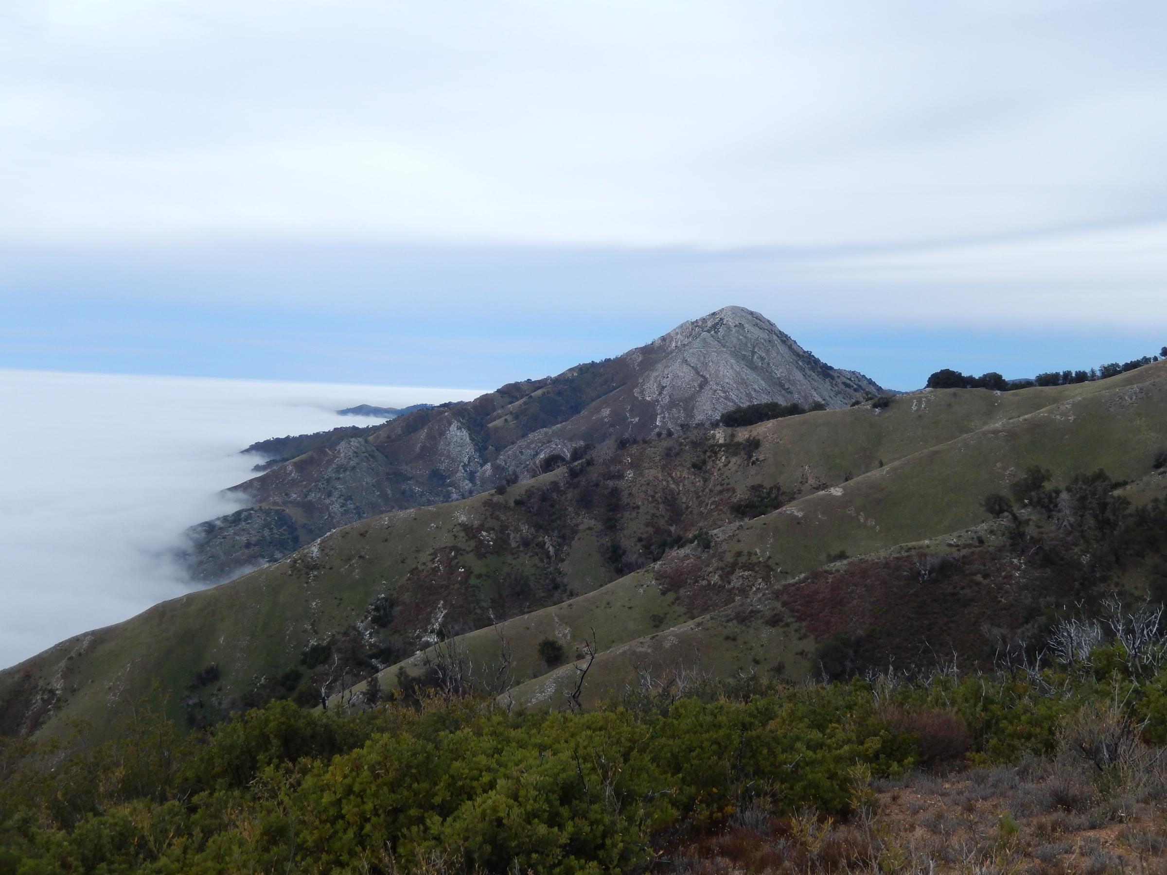
The East Molera hotspot encompasses the portion of Andrew Molera State Park east of Highway 1. While a small part of this area is visible from the first mile of the Old Coast Road, that area is covered by the "Old Coast Road (south end)" hotspot. To access the East Molera hotspot, one must hike. The trail begins near the old barn north of the BSOL/Discovery Center. After a short uphill segment the trail passes under Highway 1 through an old cattle tunnel, then heads yet further uphill. An alternative entry is through a small gate along the highway, a hundred yards south of the main Molera State Park entrance, which quickly joins the trail from the barn and tunnel. The trail continues uphill on an old ranch road. The trail is very steep — occasionally astonishingly steep! It breaks out into the open at the base of the Coast Ridge, then begins a long switchback to the north, passing through coastal chaparral. The trail crests the ridge near a small redwood grove (approximately 2 miles from Highway 1), then continues south along the ridge through grassland, ascending in a series of plateaus, to a final ridge summit (2 miles from the redwood grove). A rough firebreak provides further access for the intrepid to Post Summit (see Post Summit hotspot). On the way up the views grow increasingly splendid, and the vista from the ridgetop is nothing short of spectacular, with Pico Blanco rising steeply to the north, the full sweep of Point Sur, the mouth of the Big Sur River, Molera State Park to the west, and the Coast Ridge to Mount Manuel to the south. In some years the wildflower display in the chaparral and grasslands is outstanding.
This Hotspot is a stand-alone hotspot. Record all birds seen on this hike, but do not include any birds seen west of Highway 1 within Andrew Molera State Park (there is another hotspot for that portion of the park). The only restrooms are at the main parking lot west of Highway 1, where there is a fee for entry. There are not formal restrooms within that part of Andrew Molera State Park which lies east of Highway 1. There is no fee for this trail if you park near the trailhead on Highway, but there is a fee if you use the main parking lot west of the highway. There are annual and semi-annual passes for all of Andrew Molera State Park.
About Andrew Molera State Park
See all hotspots at Andrew Molera State Park
In the spectacular Big Sur area, Andrew Molera State Park is relatively undeveloped and offers visitors great hiking and beachcombing as well as panoramic views of the Monterey Bay National Marine Sanctuary, a federal marine protected area. Miles of trails wind through meadows, bluffs, beaches and hilltops.
Andrew Molera State Park, 22 miles south of Carmel on Highway One, contains 4,766 acres, with miles of trails winding through meadows, beaches and hilltops and the Big Sur River running through the park. The park is a Watchable Wildlife site.
Also located within the park is the now-closed Ventana Wilderness Society’s Big Sur Ornithology Lab (BSOL). Visitors were able to visit the Lab and, during most of the year, observe the morning bird-banding and research activities. Much of the data from the 1990s and early 2000s was obtained by BSOL. BSOL was operated for 18 years, from 1992 to 2010.
When Frances Molera sold the family ranch that was to become the state park, it was with the condition that it be named after her brother Andrew. Visitors can see the former ranch complex. The Molera Interpretive Center, located in the old ranch house, provides a fascinating glimpse into the park’s rich natural and cultural history.
Features
Restrooms on site
Wheelchair accessible trail
Roadside viewing
Content from California State Parks page on A. Molera trails, Andrew Molera State Park Official Website, Francis Toldi, and Discover California State Parks in the Monterey Area
Last updated March 7, 2023