Mt. Graham--Ladybug Trail
Mt. Graham--Ladybug Trail
Swift Trail Junction, Arizona 85546
Official WebsiteMt. Graham Official Website
About this Location
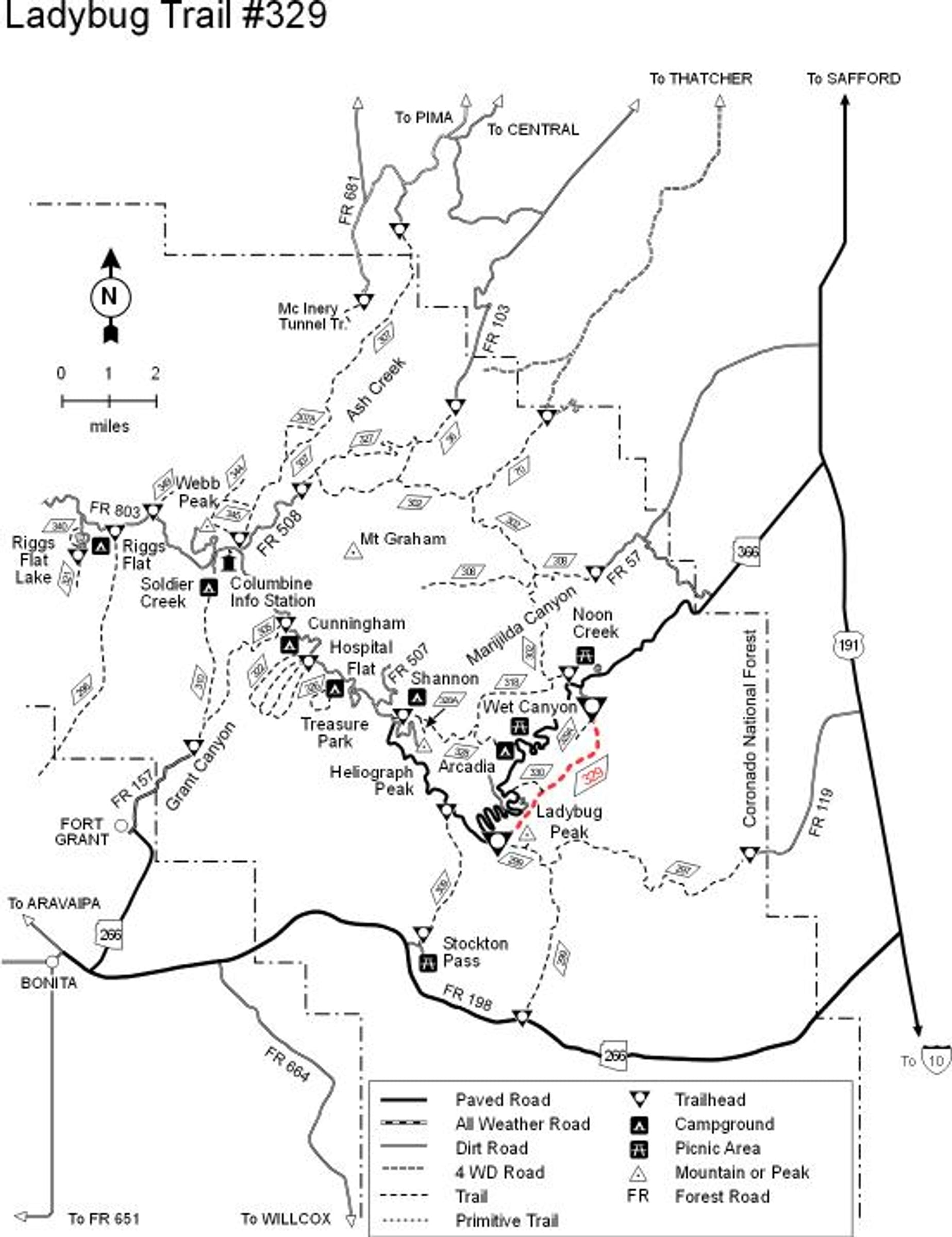
This trail gets its unique name from the fact that it starts near Ladybug Peak, a place where large numbers of these small, orange-colored, black-spotted beetles congregate at various times of the year. The upper trailhead is located in stands of mixed conifers from which the setting changes gradually to oak woodland and eventually to manzanita and desert scrub as the trail drops into Jacobson Canyon at its lower end. Most people choose to travel the trail in this downhill direction because it is quite steep. A good reason to choose to go the other way, however, is if the upper trailhead is snowed in after a winter storm. Scenery along Ladybug Trail includes good overlooks of Jacobson Canyon and views of the Swift Trail (AZ 366) as it snakes its way up the mountain. In the distance, the Gila Mountains and Gila Valley provide a broad and scenic backdrop.
From Safford, Arizona: Take US 191 south for 6 miles. Turn right onto AZ 366/Swift Trail and travel approximately 17 miles. The trailhead is on the left side of the road.
About Mt. Graham
See all hotspots at Mt. Graham
Mount Graham is the tallest of southeastern Arizona’s sky islands—mountain ranges that rise like forested islands out of a desert sea. Ascending this mountain is the ecological equivalent of traveling from Mexico to Canada. Varied biotic communities, layered in life zones, provide ideal habitat for a diverse array of plants and animals, including endemic species found nowhere else in the world.
Known as Dził Nchaa Si’an (or Big Seated Mountain) to the Western Apache, Mount Graham has been home to Indigenous people for thousands of years.
In the late 1800s, Apache tribes that lived here for generations were forced onto reservations, restricting their access to the natural resources and spiritual sites on this mountain. Mount Graham still holds profound cultural significance to tribes today, and many sites are considered sacred.
An influx of Mormon farmers and ranchers in the late 1800s, and mining ventures in the early 1900s, prompted a need for lumber from the pine-covered mountain. Numerous sawmills were built across the range; remnants of some mills are present today.
The Swift Trail follows the original wagon route used to transport lumber down the mountain. Place names along the parkway recall early pioneers, from the namesake Forest Supervisor T. T. Swift, to the families that tended orchards, planted crops, and grazed cattle along the mountain creeks and meadows.
The Civilian Conservation Corps, which employed young men in the 1930s during the Great Depression, had multiple camps on Mount Graham. They constructed roads and bridges, such as the original stone bridge that crossed Wet Canyon. They also developed recreation sites on the mountain, including many of the trails and campgrounds enjoyed by visitors today.
Features
Restrooms on site
Wheelchair accessible trail
Entrance fee
Roadside viewing
Content from Official Website and Mt. Graham Visitor Guide
Last updated November 13, 2023
 National Forest Service
 National Forest Service