Merrimack River Conservation Area (SPNHF) (overall), Concord
Merrimack River Conservation Area (SPNHF) (overall), Concord
Society for the Protection of New Hampshire Forests Concord, New Hampshire 03301
Merrimack River Conservation Area Official WebsiteMerrimack River Conservation Area map
Merrimack River Watershed Association website
Merrimack River (National Park Service) wepage
Tips for Birding
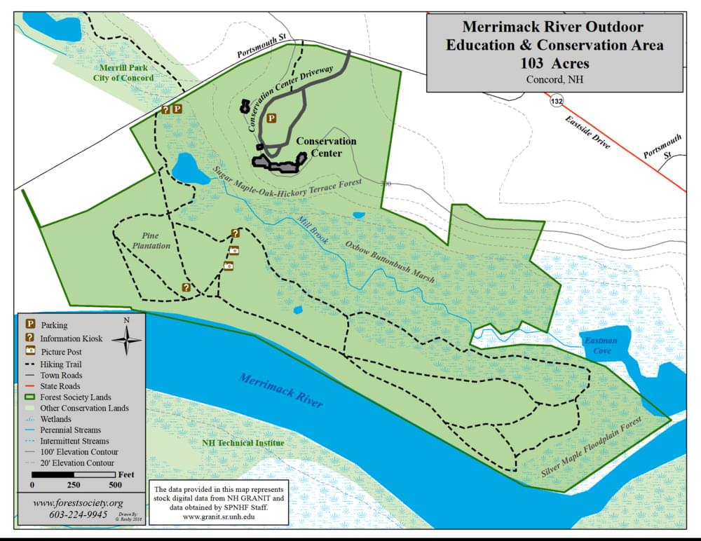
Merrimack River Conservation Area is located in East Concord. From I-93 exit 16, go east on West Portsmouth Street 0.1 mile, bearing right very briefly onto NH-132, then left onto East Side Drive. Go 0.7 mile, and turn right on Portsmouth Street, and go .4 mile to the bottom of the hill (past the entrance to the headquarters of the Society for the Protection of New Hampshire Forests) to the parking area and trailhead on the left. You have to walk left out of the lot along the road about 30 feet to the beginning of the yellow-blazed trail.
Merrimack River frontage, backwaters, and marshes. Tree plantations and floodplain woodlands. 1.25-mile Les Clark Nature Trail loops through all habitats. The Forest Society headquarters has restrooms, exhibits, and a gift shop. Note: Access to the trails from the Forest Society HQ via the long stairway down the hill is now closed–the bridge across the creek is gone and that area is now designated a wildlife sanctuary.
Birds of Interest
Spring, summer, and fall birding.
Bank, Barn, Northern Rough-winged, and Tree Swallows along the Merrimack River bank. Red-bellied, Hairy, and Downy Woodpeckers in the floodplain woods. Belted Kingfisher, Spotted Sandpiper, and waterfowl in the marshes and river shore. Warblers, flycatchers, and other passerines in the woods and streamside.
About Merrimack River Conservation Area
See all hotspots at Merrimack River Conservation Area
Several types of floodplain forest natural communities may be seen along the trail system below the Forest Society’s headquarters, including one near the river’s edge that is dominated by tall silver maples leaning over the river (this is a portion of an exemplary silver maple – false nettle – sensitive fern floodplain forest that occurs in patches along the banks of this stretch of the river). Other natural communities found here include a hardwood terrace forest dominated by sugar maples, oaks, and hickories, as well as marshes, ponds, and streams.
About Merrimack River
See all hotspots at Merrimack River
The Merrimack River is a 117-mile-long river in the northeastern United States. It rises at the confluence of the Pemigewasset and Winnipesaukee rivers in Franklin, New Hampshire, flows southward into Massachusetts, and then flows northeast until it empties into the Atlantic Ocean at Newburyport. From the point where the Merrimack turns northeast in Lowell, Massachusetts onward, the Massachusetts–New Hampshire border is roughly calculated as the line three miles north of the river.
Features
Restrooms on site
Wheelchair accessible trail
Entrance fee
Content from Merrimack River Conservation Area Official Website
Last updated October 31, 2023