Bandelier NM--Mouth of Alamo Canyon
Bandelier NM--Mouth of Alamo Canyon
White Rock, New Mexico 87547
Burro Trail to Sego Lilies webpageBandelier National Monument Official Website
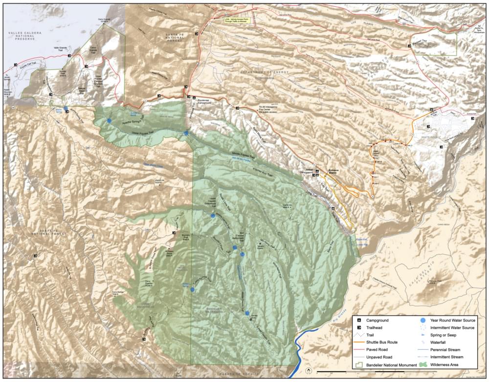
Bandelier National Monument map
About Bandelier National Monument
See all hotspots at Bandelier National Monument
Bandelier National Monument sits at the southern end of the Pajarito (Spanish for little bird) Plateau. The plateau was formed by two eruptions 1.6 and 1.4 million years ago. Home to the Bandelier Wilderness, Bandelier ranges from 5340 ft at the Rio Grande to the south and 10199 ft at the summit of Cerro Grande to the north, almost a mile of elevation change in just under 12 miles. This elevation gradient creates a unique diversity of habitats specific to Northern New Mexico. The diversity of habitats and quick access to water supported a relatively large population of Ancestral Pueblo people. Currently, Piñon-Juniper woodlands dominate in the southern parts of the park transitioning through ponderosa pine savannahs and forests finally reaching mixed conifer forests at the highest elevation. Scattered throughout the park are desert grasslands, montane meadows, and riparian areas in the canyon bottoms. Bandelier is home to a wide variety of wildlife. The backcountry trails at Bandelier climb in and out of deep canyons and cross large flat mesas, showcasing the entire spectrum of volcanic geology.
Bandelier is set within vast amounts of open space. North and west of the park rests the Valles Caldera National Preserve (VCNP), an 89,000-acre nature preserve, which was created by the eruptions that formed the Pajarito Plateau followed by volcanic subsidence. On all sides of the park sits over one million acres of the Santa Fe National Forest, with the Dome Wilderness adjoining the western edge of Bandelier Wilderness. A large portion of the northeastern boundary is shared with Los Alamos National Lab, which covers 26,500 acres of restricted, mostly open space. Bandelier’s direct neighbors make the park’s 34,000 acres feel much larger than it is.
Access to Bandelier National Monument is by a free shuttle bus in the summer months.
Notable Trails
The hotspot can be reached by hiking the Burro Trail from its trailhead near Cottonwood Campground. Measurements of one-way trail length (probably depending on the starting point) vary from 4.5 to 6 miles. As the final descent is somewhat steep, remember that some of your greatest efforts will be expended as you climb out, that is, after half the 9-to-12-mile round trip.
The Hiking Project website has a description and map of a hike on the Burro Trail.
Features
Entrance fee
Restrooms on site
Wheelchair accessible trail
Content from Bandelier National Monument Official Website and John Montgomery
Last updated August 29, 2023