Ridge Hill Reservation
About this Location
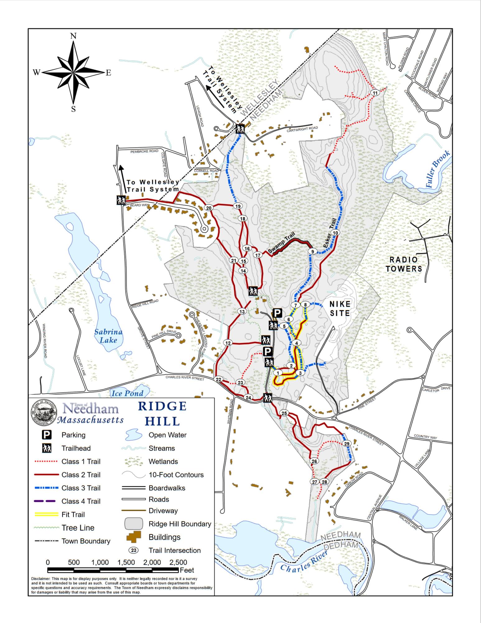
Ridge Hill Reservation includes 352 acres of public open space under the control of the Conservation Commission. It is made up of several properties that were formerly owned privately but are now part of the Reservation.
The southern portion of Ridge Hill Reservation extends from the Charles River to Charles River Street and is bordered by two large undeveloped parcels in private ownership. There is currently one privately-held parcel with frontage on Charles River Street that is surrounded on the other three sides by Ridge Hill Reservation. The main portion of Ridge Hill Reservation extends from Charles River Street to the Wellesley town line at the Wellesley Transfer Station (on Central Avenue). Access points from public streets are located on Beard Way, Cartwright Road, and Pine Street in addition to the main entrance from Charles River Street. This section is bordered by private single-family residences on Charles River Street, Pheasant Landing, Grove Street, Beard Way, Lehigh Road, and Cartwright Road on the south and west, and by private single-family residences on Mary Chilton Road and Pine Street on the east. Other sections of the east side of Ridge Hill Reservation are bordered by undeveloped lands, including 2 extensive wetlands owned by, or protected by easements held by, the U.S. Army Corps of Engineers under the Natural Valley Storage program, the radio tower land, and farmland owned by the Volante Farm. The former Nike missile site is an undeveloped property embedded within the eastern portion of Ridge Hill Reservation and accessed by a road easement from Pine Street. Wetlands within the Ridge Hill Reservation are also protected by easements held by the Corps of Engineers.
Much of Ridge Hill Reservation and its bordering lands are wetlands and floodplains. The southern section includes a wetland system consisting of an intermittent stream and vegetated wetlands that border the stream. This stream flows into the Charles River and originates in a small wetland just south of Charles River Street. The extensive wetlands along the east side of Ridge Hill are associated with Fuller Brook, which drains to the north through Wellesley and eventually into the Charles River. The large central wetland, located between the Esker Trail and the Chestnut Trail, is a tributary to the Fuller Brook system, which flows north under Cartwright Road. The large wetland system in the western portion of Ridge Hill, south of Beard Way, appears to be isolated. Two additional small ponds are between the access road and Pheasant Landing. The southernmost, near the intersection of the driveway with Charles River Street, is a fen containing plant species that grow nowhere else in Needham.
Ridge Hill Reservation together with surrounding undeveloped lands (the Nike Site, the WGBH Towers, the Tennis Club, the Eastman Conservation Area at the Newman School, the Ann Volante Conservation Area, the former town Landfill, and the Jacob Wildlife Sanctuary) is the largest contiguous unfragmented, undeveloped land (forested, meadow, wetland) in Needham west of I-95, comprising nearly 1,000 acres of wildlife habitat. The size of this largely intact natural area provides many significant values to the town – flood storage and flood damage protection, water quality protection, groundwater recharge of the town's aquifer, wildlife habitat, and educational values.
Notable Trails
The AllTrails website has descriptions and maps of hikes at Ridge Hill Reservation.
Features
Restrooms on site
Wheelchair accessible trail
Entrance fee
Content from Official Website
Last updated February 10, 2024