Choke Canyon Lake--J. Daugherty WMA
Choke Canyon Lake--J. Daugherty WMA
198 Wildlife Ranch Road. Tilden, Texas 78072
Official Websitefrom James Daughtrey Wildlife Management site
Wildlife Management Areas of the Texas Official Website
Public Hunting Lands Map booklet
Tips for Birding
General Public Use is allowed only from April 1- August 1. Contact the Area Manager for details.
The eBird Hotspot location is off of Farm to Market 3445, just north of the Frio River feed into Choke Canyon Reservoir. This is the Daaugherty Wildlife Management Office. The park road that goes by the headquarters ends at boat ramp on the Frio River.
About this Location
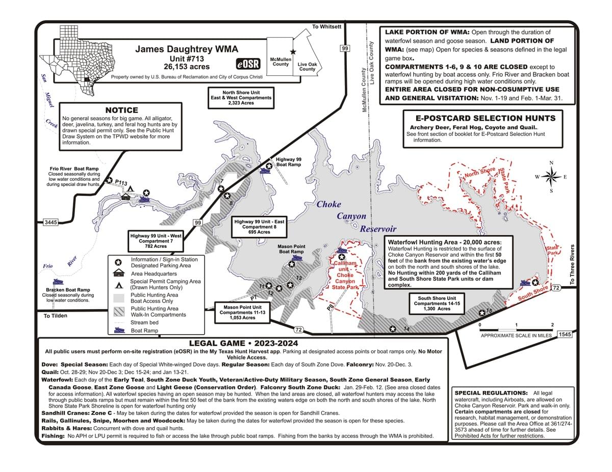
The James E. Daughtrey Wildlife Management Area (WMA) is a 34,000 acres low fenced multiple-use recreational area including Choke Canyon Reservoir. Located in Live Oak and McMullen counties. The WMA occupies all perimeter lands surrounding the lake excluding the state park units and dam operations.
The Choke Canyon Reservoir (25,733 acres) is considered part of the WMA for purposes of waterfowl hunting. All regulations applicable to waterfowl hunting, including a prohibition of airboats on the lake, apply to hunters accessing the lake for waterfowl hunting purposes. Waterfowl season is open during all open waterfowl seasons when accessed by boat through public boat ramp. An Annual Public Hunting (APH) permit is required of all waterfowl hunters. Access to the lake through the WMA is closed during special permit hunts as posted at on-site registration stations and in the Annual Public Hunting Lands Map Booklet.
Originally grassland, after the suppression of fire and the elimination of the buffalo, this region developed into the South Texas brush country of today. The climate includes long, hot summers, mild winters and erratic precipitation distribution. The average annual rainfall rate is 20-25 inches. Mesquite and associated thorny shrubs, such as catclaw acacia, huisache, blackbrush, granjeno, brasil, whitebrush, Texas persimmon, and prickly pear, account for much of the cover. Live oak, hackberry, and elm are the dominant tree species. Silver bluestem, buffelgrass, curly mesquite, and Arizona cottontop are the dominant grasses throughout the WMA. The topography is gently sloping to level and the soils range from loamy sand to heavy clay.
Texas Parks and Wildlife assumed responsibility of the property in 1981 for the care, operation, maintenance, and replacement of the recreation, fish and wildlife, and open space resources of the Choke Canyon Reservoir. The WMA historically has been used as a public use area to provide optimum hunting opportunity and appreciable public use, commensurate with availability of the resource. The Daughtrey WMA offers an interpretive nature trail, wildlife viewing, and hunting. Fishing is available on Choke Canyon Reservoir through access by public boat ramp.
The James E. Daughtrey WMA is named in memory of state game warden James E. Daughtrey, who was fatally injured in a vehicle accident while pursuing game law violators in McMullen County.
About Choke Canyon Reservoir
See all hotspots at Choke Canyon Reservoir
Choke Canyon Reservoir (25,733 acres) is located in Live Oak and McMullen counties. The WMA occupies all perimeter lands surrounding the lake excluding the state park units and dam operations.
Originally grassland, after the suppression of fire and the elimination of the buffalo, this region developed into the South Texas brush country of today. The climate includes long, hot summers, mild winters and erratic precipitation distribution. The average annual rainfall rate is 20-25 inches. Mesquite and associated thorny shrubs, such as catclaw acacia, huisache, blackbrush, granjeno, brasil, whitebrush, Texas persimmon, and prickly pear, account for much of the cover. Live oak, hackberry, and elm are the dominant tree species. Silver bluestem, buffelgrass, curly mesquite, and Arizona cottontop are the dominant grasses throughout the WMA. The topography is gently sloping to level and the soils range from loamy sand to heavy clay.
Texas Parks and Wildlife assumed responsibility of the property in 1981 for the care, operation, maintenance, and replacement of the recreation, fish and wildlife, and open space resources of the Choke Canyon Reservoir
About Wildlife Management Areas of the Texas
See all hotspots at Wildlife Management Areas of the Texas
Many Texas Wildlife Management Areas are open for activities such as biking, primitive camping, birding, fishing, hiking, equestrian activities, driving tours, and wildlife viewing.
Many times you need minimally a Texas Limited Public Use Permit (LPU - #175). You can purchase a Limited Public Use Permit or Annual Public Hunting Permit at any location that sells hunting licenses or at the Texas License Connection. If purchased online a representation of receipt is acceptable until official printer version has been mailed to you. In some cases it's not obvious when you need a permit for a Texas Wildlife Management Area so it might be better to be safe, because Texas game wardens do check for such permits.
Content from from James Daughtrey Wildlife Management site, Wildlife Management Areas of the Texas Official Website, Public Hunting Lands Map booklet, and Dell Little
Last updated November 27, 2023
 Dell Little