Salinas Pueblo Missions NM--Quarai Ruins
Salinas Pueblo Missions NM--Quarai Ruins
Manzano Quarai Road
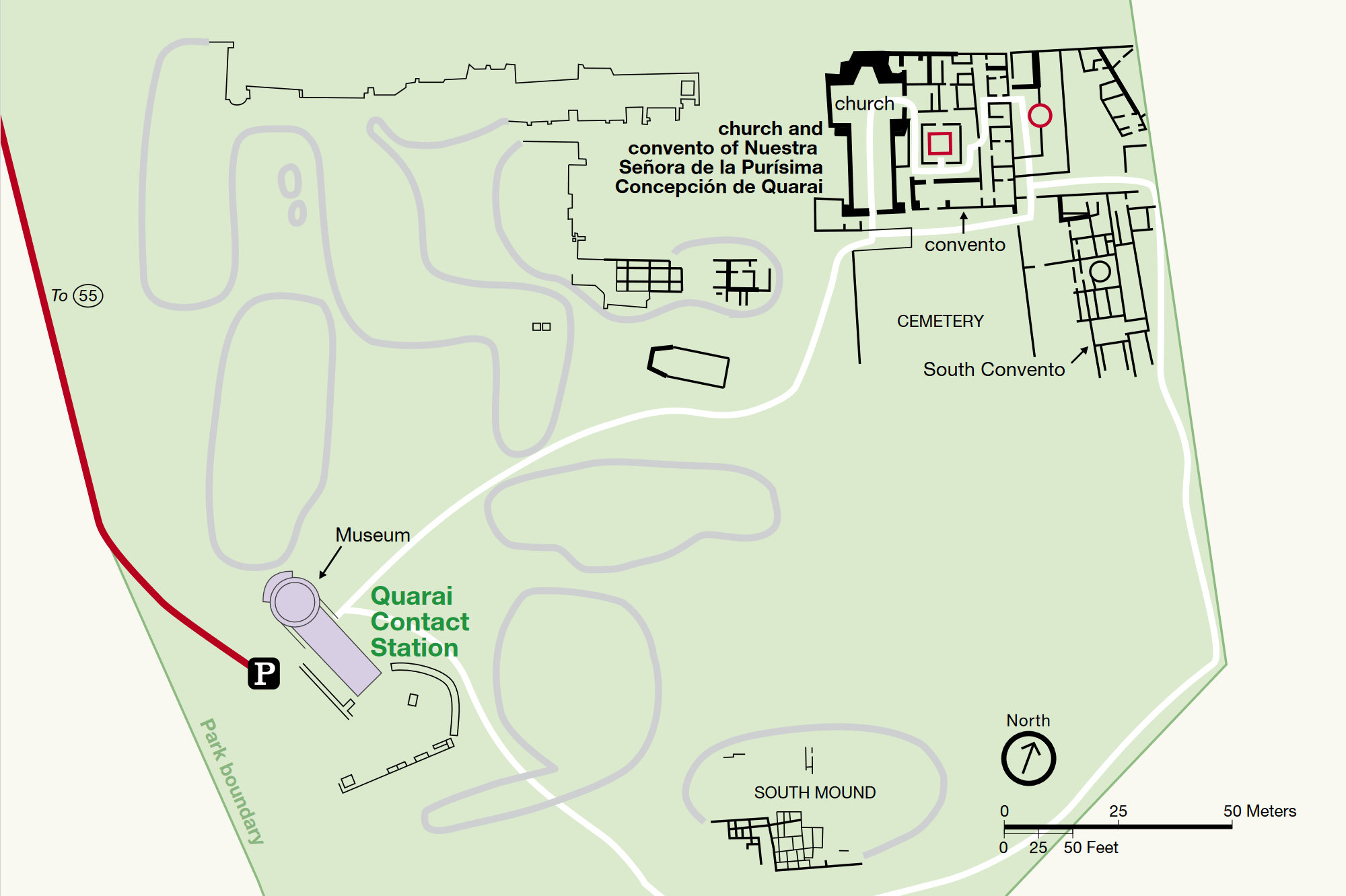
Virtual Tour of QuaraiSalinas Quarai Ruins map
Salinas Pueblo Missions National Monument Official Website
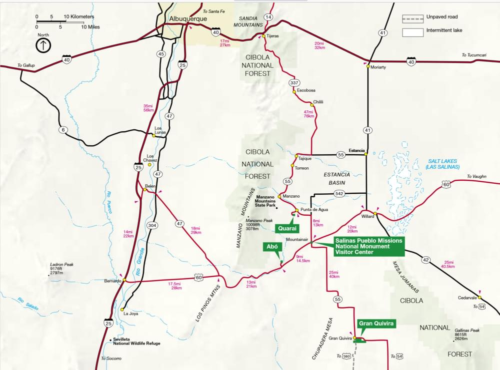
Salinas Pueblo Missions National Monument map
Manzano Mountain Wilderness Official Website
Manzo Mountain Wilderness (Wilderness Connect) webpage
Manzo Mountains (SummitPost) webpage
About this Location
Early bird records are scarce for Salinas, and, when extant, pertain mainly to Gran Quivira, which, as the only unit with federal Monument status until 1980, attracted most of the research efforts. Thus, early on, the birds of Salinas were seen through the monochromatic prism of GQ, where the absence of water made for relatively low bird diversity. However, recent ornithological investigations since 1996, have revealed extraordinary biological riches at Quarai, where perennial waters support cottonwoods and other riparian vegetation, including many fruiting shrubs–and as a result, a wide variety of birds.
This year, a pair of Cooper’s Hawks nested along the Spanish Corral Trail, and Great Horned Owls nested in the ruins. One of the latest spring arrivals can be the somberly-clad, but very stylish Phainopepla, which here at Quarai is at the northern limit of its range. Eggs are generally laid during the latter part of June, with young generally fledging by the end of July when chokecherries and currants begin to ripen. Other nesting birds at this oasis on the edge of the Manzano Mountains, include Ladder-backed Woodpecker, Western Wood-Pewee, Say’s Phoebe, Plumbeous Vireo, Rock Wren, Western Bluebird, Mountain Bluebird, Yellow-breasted Chat, Western Tanager, Black-headed Grosbeak, Blue Grosbeak, and Lesser Goldfinch. Song Sparrows and White-crowned Sparrows are indicators of the winter season, which, although much subdued compared to the hectic pace of summer, may feature such interesting visitors as the Virginia Rail or the Marsh Wren.
While summer and winter have certain predictability about them, migration at Quarai is the deck containing the Joker that can make the most far-flung hope a reality. Because Quarai can be such a vortex of birds in spring and fall, the Park Service and the Forest Service have joined to celebrate World Migratory Bird Day here since 1998. Already 92 species have been recorded on that second Saturday in May between 1998-2002. This list includes fifteen species of warblers, of which the Blue-winged and the Chestnut-sided are, perhaps, the most distinguished.
About Salinas Pueblo Missions National Monument
See all hotspots at Salinas Pueblo Missions National Monument
Tucked away in the middle of New Mexico you’ll find the Salinas Pueblo Missions National Monument. Its three distinct sites offer a glimpse into a unique time in history—a time entrenched with cultural borrowing, conflict, and struggles. These sites continue to stand as reminders of the Spanish and Pueblo peoples’ early encounters and prompt exploration of today’s interactions among different people.
For hundreds of years, the Missions, Pueblos, Kivas, and Homesteads of Salinas Pueblo Missions National Monument have stood as testaments to the people and cultures that have called this area home. From the prehistoric Ancestral Puebloan and Jumano groups to the 17th century Spanish Franciscan missionaries, the returning settlers of the 1800s, and the 19th and 20th-century archaeologists and Park Service employees, the People, Places, and Stories of the Salinas Pueblo Missions make this a special place.
By National Park standards Salinas has modest dimensions, scarcely exceeding 1000 acres, and even these are not contiguous, but split into three units spaced as far as 35 miles apart. And yet, while considerable diversity of birds and habitats might have been expected in such a scattershot park, the homogeneity of habitat in this piñon/juniper life zone is a decidedly unifying factor, which allows the Salinas bird list to be broadly applicable to all three units. Still, each of the units (Gran Quivira, Quarai, and Abó) has its distinctive signature, dependent in large measure on the availability of wetland resources. Amazingly, in seven short years (1996-2002) more than 150 bird species were documented for Salinas. And if you’re looking for birds, Quarai is the place to find them.
About Manzano Mountain Wilderness
See all hotspots at Manzano Mountain Wilderness
The 36,875-acre Manzano Mountain Wilderness Area is located in the Mountainair Ranger District. It was designated as a wilderness area in 1978. The word “Manzano” is Spanish for apple trees, which is what explorers discovered on the eastern edge of the mountains back in the early 1700s. Apple trees are not native to this part of the country, so the mountains were named because of the discovery of these old apple trees.
Spread out across the western slope of the Manzano Mountain Range, this wilderness varies in elevation from about 6,000 feet to 10,098 feet. The terrain is steep and rugged cut with canyons and marked with outcroppings of rock. Thousands of raptors migrate along the Manzanos in spring and fall as they work their way between Canada and Mexico.
Vegetation consists of piñon and juniper at lower heights, gradually taken over by ponderosa pine and then spruce, fir, and aspen higher up. More than 64 miles of a well-developed trail system provide access to the wilderness.
Running for some 40 miles through central New Mexico, east of the Llano de Manzano and west of Estancia Valley, the Manzano Mountains are one of four seemingly connected north-south oriented ranges; from north to south these ranges are the Sandia, the Manzanita, the Manzano, and the Los Pinos Mountains. The southern end of the Manzano Mountains is generally agreed to be Abo Canyon (also known as Abo Arroyo), through which travels US-60. USGS maps show Hell Canyon (Hells Canyon on other maps), on the western slope, as dividing the northern end of the Manzanos from the southern end of the Manzanitas. Hell Canyon is Pueblo of Isleta tribal land, at the northeast corner of Valencia County. Tribal Road 12 extends east into the canyon.
Manzano Peak, at 10,098 FASL the highest point in the range, is part of the 36,875 acre Manzano Wilderness, situated on the range’s western slope. Most of the Manzano Mountains are located within Cibola National Forest, though tribal, state and private land may be found within the range. A relatively small parcel adjoining the wilderness has been designated as a Wilderness Study Area and is administered by the Bureau of Land Management.
Torrance County encompasses almost all of the Manzanos, though some western portions of the range lie within Valencia County (and possibly by some interpretations, a northeast corner of Socorro County), whereas the northernmost portion is in Bernalillo County. As of summer 2023, there are no Manzano Mountains hotspots in Bernalillo or Socorro counties.
Content from Salinas Pueblo Missions National Monument Official Website, Cibola National Forest Wilderness Areas, and John Montgomery