Buffalo National River--Erbie

Buffalo National River--Erbie
Erbie, Arkansas 72601
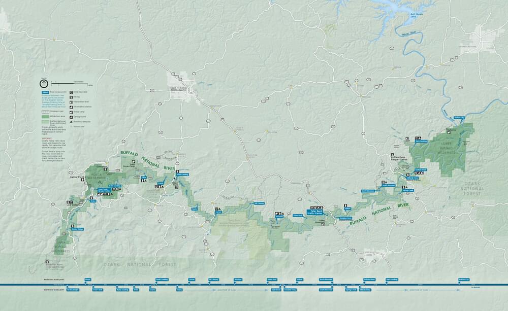
Buffalo National River Official WebsiteBuffalo National River maps
About this Location
Exploring the three trails described below will cover most of the interesting habitats at Erbie. The drive from highway 7 is six miles on a dirt road with several interesting stops, starting with Koen Forest, another listed hotspot. It is advised to keep speed down to avoid potholes and the occasional oncoming vehicles, which can appear suddenly on the many curves. Cell phone reception is spotty and nonexistent at the campground. In-season spray clothing for ticks and chiggers, especially if you stray off the trails.
About Buffalo National River
See all hotspots at Buffalo National River
Established in 1972, Buffalo National River flows freely for 135 miles and is one of the few remaining undammed rivers in the lower 48 states. Once you arrive, prepare to journey from running rapids to quiet pools while surrounded by massive bluffs as you cruise through the Ozark Mountains down to the White River.
Notable Trails
The entrance to the Erbie Campground is on the right. At the T, turn right and park at the canoe landing. There are vault toilets here.
Area #1. Walk down to the river and take the trail to the left, which parallels the river. The path opens into the group camping area. Cross this mowed section. Explore beyond where the campground is no longer open for camping, then go uphill to meet the campground road. Assuming you have reached the opposite side of the campground from the canoe landing, look for a trail through scrub and to a water seep that birds find attractive. Shortly, you will come to an open field (planted for elk) and a large stand of river cane. (If recently mowed, this trail continues all the way to the Parker Hickman Historic site and area #2). Return to your vehicle along the upper road.
Next to the toilet building, a trail goes down the river (in spring, good wildflower displays). This section is worth a short exploration but requires turning back at some point as you will be on the Buffalo River Trail, which continues downstream to Ozark Campground. To reach area #2, leave the campground, turn right .and drive ¾ mile to the Parker Hickman Historic site.
Area #2 Immediately upon crossing a low water bridge at Webb Creek, which can be dry or a roaring torrent capable of sweeping cars off the bridge, turn into the Parker Hickman Historic site. A trail to the left before passing through the gate parallels the creek. Explore this trail a short distance until it meets a gravel track, then turn back. Walk the road away from the Historic site for about ¼ mile to a river overlook. Return the same way or walk a bit further, and at the field (on the left), take the trail up the hill to where the trail forks. Go left to return to the Hickman site with fields on your right and second-growth forest on your left. For a longer trek, take the right-hand fork. This is area #3.
Area #3. This trail goes upriver with spectacular views from high above. If you are accessing this loop from area #2, watch for a side trail that occurs partway down at a drop in elevation. This dead-end leads to a spot where once there was an old swinging bridge and good views. Continue on the loop trail taking a left turn when you reach an old wagon road. Shortly, you will pass the Cherry Grove Cemetery. The road ahead through forest is relatively flat and will return to the Parker Hickman site.
Area #3 loop can be accessed from the historic site by passing through the gate and following the road to the Cherry Grove Cemetery. Just past the cemetery, take the first trail on the right. This will eventually return you to the campground road. Turn right and walk back to your vehicle.
For less walking, it can be productive to drive the campground road, then continue to the Parker Hickman site, and end at the river overlook.
Features
Restrooms on site
Roadside viewing
Wheelchair accessible trail
Entrance fee
Content from Buffalo National River Official Website and Jack Stewart
Last updated January 31, 2023
 National Park Service