Tupancy Links
Tupancy Links
Nantucket Conservation Foundation 165 Cliff Road Nantucket, Massachusetts 02554
Official WebsiteTupancy Links trail guide and map
About this Location
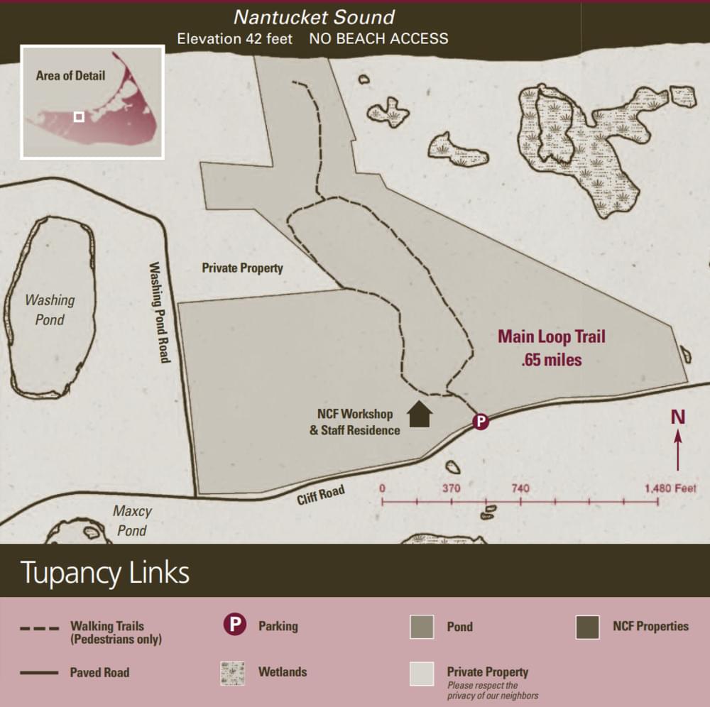
Tupancy Links, 73 acres, occupies a lovely area located between Nantucket Harbor and Cliff Road and is one of the Foundation’s most popular properties. A former nine-hole golf course, the property was donated by Sallie Gail & Oswald “Tup” Tupancy to preserve its natural beauty and to prevent further development of this area of the island. There are approximately 1.5 miles of clearly marked trails that wind through several of the course’s old holes (outlines of tees and greens are still visible) and pass by a spectacular view of Nantucket Harbor and the Island’s north shore.
The Tupancys probably could have never imagined that their gift of this land would not only protect this area from development but would also become one of the most popular dog-walking areas on Nantucket. However, as a result of the Foundation’s “open to all” policy, this private land has become important to the Island’s canine population for their daily exercise and socializing.
The Tupancy Links is located at 165 Cliff Road which is approximately 1 mile from Main Street. There is a large parking lot with an information kiosk directly in front of the trailhead. The Cliff Road bike path also goes right past the entrance to the property. Please note that there are no public facilities or beach access available at the Tupancy Links.
The Tupancy Links was originally part of the Nantucket Golf Course, established in 1921 as the first golf club on the island. This small operation consisted of a nine-hole course mowed by 200 sheep and 50 Angora goats. As golf became more popular on Nantucket, the course expanded to eighteen holes, and a permanent clubhouse was constructed in 1926 at 118 Cliff Road. In 1981, this building was acquired by the Foundation from other benefactors and was transformed into the organization’s administrative office.
In 1949, Mr. Tupancy, a talented and dedicated golfer, purchased enough of the Nantucket Golf Course property to operate a nine-hole course. By this time, the balance of the course’s original acreage south of Cliff Road was gradually being converted to house lots. Mr. Tupancy operated his course for only a few years, closing it to play in 1953. He and his wife, Sallie Gail Harris Tupancy (who served on the Foundation’s Board of Trustees), donated the Tupancy Links property to the Nantucket Conservation Foundation in several transactions occurring between 1976 and 1987.
Mr. and Mrs. Tupancy also provided an abutting parcel of land for the construction of the Foundation’s staff residence and workshop facility, located just west of the parking area on Cliff Road. This portion of the property was contributed specifically to address the management needs of the Tupancy Links, as well as other Foundation properties. The Foundation’s year-round and seasonal staff has made good use of the much-needed workshop, equipment storage barn, and residence since its completion in 1993. A portion of this area also contains a small greenhouse that is used to propagate native plant species used in various restoration projects on the Foundation’s conservation lands, as well as an organic vegetable garden for the Foundation’s employees.
The rolling, expansive grassland habitat is now maintained by the Foundation through mowing, often conducted just before the spring growing season. The dominant grass in this area, Little Bluestem, forms 2-3 foot tall flowering stems in the late summer that turn a distinctive purplish-blue color in early autumn, thus giving the species its common name. In addition to Little Bluestem, a wide variety of wildflowers and other native grasses can be observed here, including sandplain blue-eyed grass, ox-eye daisy, evening primrose, Pennsylvania sedge, yarrow, Queen Anne’s lace, and a variety of goldenrods and asters. Mowing these areas only once per year at the beginning of the growing season allows the native grasses and wildflowers to grow, flower, and set seed throughout the summer, fall, and early winter. This management is an important and effective means of maintaining this unique open habitat.
Plants belonging to the heathland plant community are also abundant on the property. An evergreen, woody ground cover shrub known as bearberry, with pink flowers in early spring and bright red, pea-sized berries in late summer and fall, covers slopes along the trails. False heather is a low-growing ground cover that bears brilliant yellow flowers in early summer. Thickets of bayberry, beach plum, pasture rose, low bush blueberry, and black huckleberry are also abundant on the property, all of which serve as important sources of food and cover for wildlife such as eastern cottontail rabbits, white-tailed deer, and numerous of songbirds.
The path to the bluff (a former golf course service road) slopes upward past shrub thickets that become interspersed with beach grass near the bluff. The cliff at this location is approximately 42 feet above sea level and regularly experiences high rates of erosion. Please stay behind the fence and away from the edge of the bluff, which is extremely steep. The vantage point from this location provides a spectacular scenic view of the north shore. Down the shoreline to the east, Jetties Beach and the entrance to Nantucket Harbor are visible, with Coatue beyond. On a clear day, the Great Point Lighthouse can be seen 8 miles away to the northeast. The church steeples, Town Clock, and whaling captain’s mansions of Nantucket Town are silhouetted against the eastern horizon. To the west are Dionis Beach and Eel Point, with Tuckernuck Island just visible on the horizon. With a good pair of binoculars, this location point offers birders an excellent vantage point for observing many species of sea birds, shorebirds, and sea ducks on Nantucket Sound.
Features
Restrooms on site
Wheelchair accessible trail
Entrance fee
Content from Official Website
Last updated March 25, 2024