BHI--Deer Island
BHI--Deer Island
Tafts Avenue Winthrop, Massachusetts 02152
Boston Harbor Islands Official WebsiteBoston Harbor Islands (National Park Service) webpage
Boston Harbor Islands map
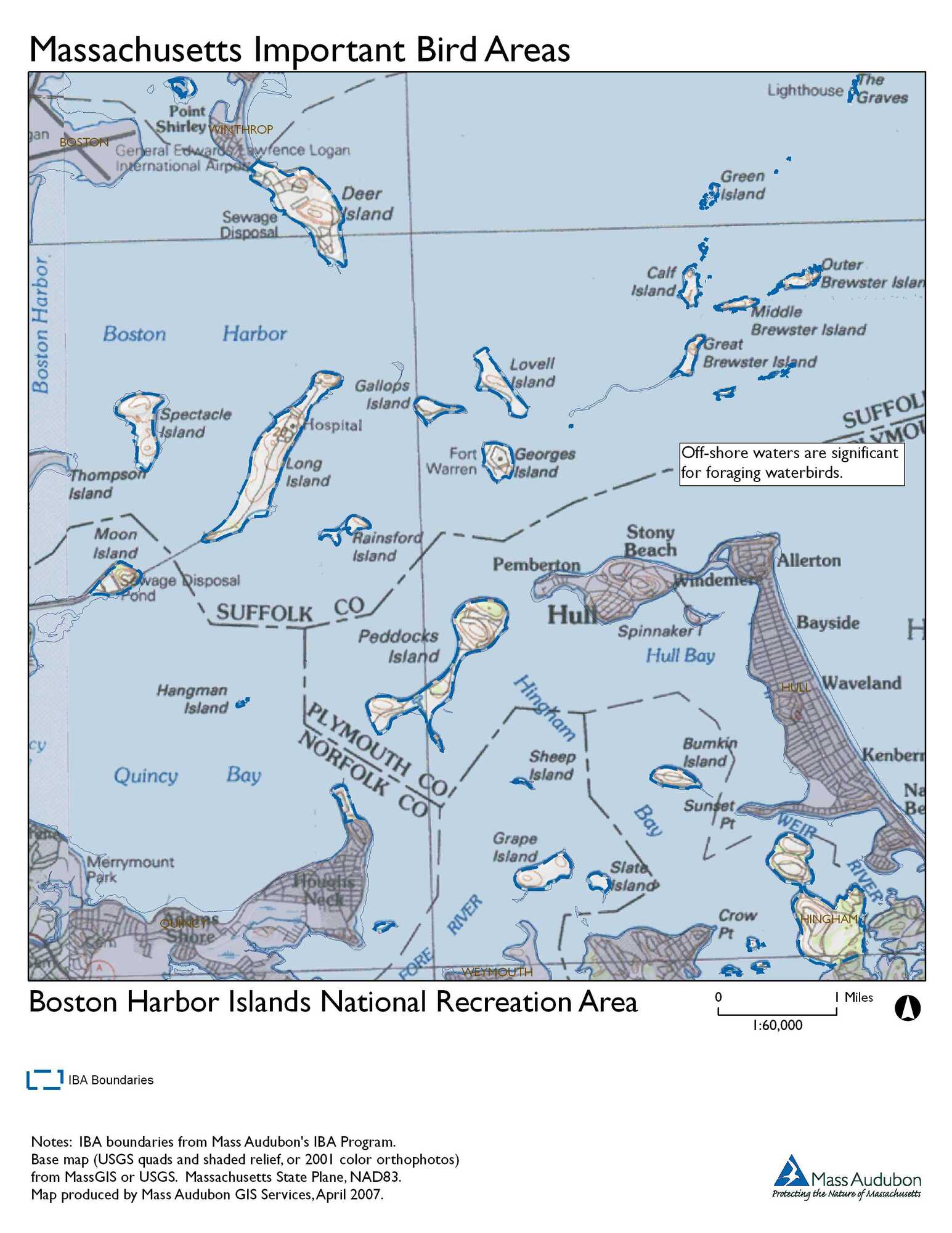
Boston Harbor Islands National Recreation Area IBA
About this Location
Tour the “state of the art” wastewater treatment facility or stroll 60 acres on the shoreline path.
Sixty acres of parkland surrounding the treatment plant offer walking, jogging, sightseeing, picnicking, and fishing. There is a 2.6-mile perimeter pathway and another 2 miles of trails on the hills of the island. (Dog walkers are reminded that dogs must be kept on a leash at all times and to clean up after their pets.)
Deer Island has been connected to the mainland since Shirley Gut, once separating the island from Winthrop, was filled in by beach erosion in the famous 1938 hurricane. The former island has a rich human history. It has been used by Native Americans, quarantined immigrants, farmers, orphans, paupers, military personnel, and tens of thousands of prisoners at the former county house of corrections.
The new Deer Island Waste Water Treatment Plant continues the longstanding use of the island for sewage disposal facilities. The first was constructed on Deer Island in the late 1800s and expanded in the 1960s. In the 1990s, hundreds of engineers and thousands of construction workers brought into being the treatment plant that now serves Greater Boston. People around Boston are proud today of Deer Island as a symbol of natural resource protection and environmental stewardship.
Some phases of Deer Island’s history, however, are far more problematic. The low point occurred during the King Philip’s War, a Native American armed resistance to 17th-century European colonization. Deer Island became a place of internment in the winter of 1675-76 for approximately 500 Native Americans, whom Europeans had removed from their homes and villages. Many of the imprisoned Native Americans died that winter without access to adequate food or shelter. In the 1800s, when the Great Famine drove more than a million Irish citizens to immigrate to the United States, Deer Island was the landing point for thousands of refugees, many sick and poverty-stricken, hoping to reach the Port of Boston. In June 1847, the City of Boston established a hospital on Deer Island. Approximately 4,800 men, women, and children were admitted for treatment in the years from 1847 to 1849. Many recovered, but more than 800 died and were buried in the Rest Haven Cemetery, where their memory now honors the struggles of their countrymen. In 1850, an almshouse was built to house “paupers.” These are only a few of the fascinating historical tales from Deer Island.
About Boston Harbor Islands
See all hotspots at Boston Harbor Islands
Located just minutes from downtown Boston, the Boston Harbor Islands include 34 islands and peninsulas spread over 50 square miles. Working with city, state, federal, and nonprofit partners, the park is a place where you can walk a Civil War-era fort, visit historic lighthouses, explore tide pools, hike lush trails, camp under the stars, or relax while fishing, picnicking, or swimming, all within reach of downtown Boston.
Between the horn of Cape Ann to the north and the defiant, jutting arm of Cape Cod to the south and east, the Boston Harbor forms a giant crescent on the central coast of Massachusetts and is the beating heart of the New England shoreline. The harbor sits within an ancient feature, known as the Boston Basin, which predates the formation of North America. Over the course of over 400 million years, it has seen tropical latitudes, multiple advances and recessions of the sea, and multiple periods of glaciation—the latter couple of which deposited and then carved many of the hills that currently dapple its surface. Today, within a vibrant metropolitan area, the Boston Harbor Islands provide a dynamic assembly of ecosystems, ranging from rocky, windswept shores to dense forests to developed and filled land—all with a long and complicated history of human use.
The hub islands, Georges and Spectacle, offer a world-class experience complete with hiking trails, picnic areas, interpretative walks, recreational programs, concessions, and state-of-the-art visitor centers. The more rustic islands, Peddocks, Bumpkin, Grape, and Lovells, provide camping adventures that offer a unique experience for locals and visitors to the Boston area. Thompson Island is open to the public via public ferries on specified weekends throughout the summer and fall.
Allow at least a half day to see one island and a day to see more. Georges, Spectacle, and Peddocks Island have fresh water and restrooms, while Lovells, Bumpkin, and Grape Island have composting toilets. There are no trash receptacles; please pack out what you pack in.
A visit to the Boston Harbor Islands is an opportunity to play, learn, serve, and work within the largest recreational open space in the Boston area.
The Boston Harbor Islands National Recreation Area comprises 34 islands ranging in size from less than 1 acre to 274 acres. A variety of habitats, including marine, rock cliffs, beaches, salt marshes, and forests support many different species in all seasons. Several species of special concern in Massachusetts have been observed on the Islands including Common and Least Tern, Barn Owl, and Common Loon. The Northern Harrier, a threatened species, also occurs on the islands. Significant numbers of colonial-nesting waterbirds, including Double-crested Cormorants, Black-crowned Night-Herons, and Snowy Egrets have been present for at least two decades. Migratory shorebirds, raptors, and songbirds utilize the harbor islands during the spring and fall, and great flocks of waterfowl overwinter there.
Features
Restrooms on site
Wheelchair accessible trail
Entrance fee
Content from Boston Harbor Islands (National Park Service) webpage and Boston Harbor Islands National Recreation Area IBA
Last updated January 9, 2024