Doe Farm, Durham
Birds of Interest
Spring, summer, and fall birding.
Scarlet Tanager, Blue-winged, Black-throated Green, and Chestnut-sided Warblers, Common Yellowthroat, Ovenbird, Great Horned Owl, Hairy Woodpecker, White-breasted and Red-breasted Nuthatches. Many other passerines are possible. Waterfowl in the river.
About this Location
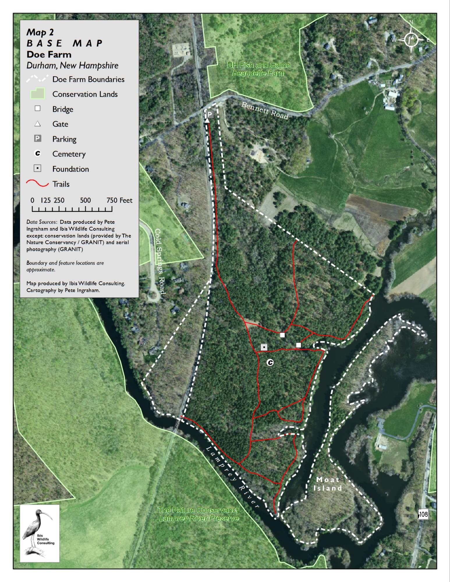
An old farmstead that is mostly wooded with pine trees, traversed by a couple of streams, and bordered on the west by a railroad right-of-way and on the south by the Lamprey River. A trail map is posted at the parking area.
Tucked between Bennett Road to the north and the Lamprey River to the south, Doe Farm offers beautiful woodland trails that lead down to the river and its backwaters. Walking with and without dogs and cross-country skiing are popular trail uses. Scouts help maintain some of the trails and bridges. Moat Island, separated from the mainland during high water, is left as a natural area, with no formal trails. The forests of Doe Farm have been harvested in the past, providing income back into a fund for maintaining the property. The property’s extensive river frontage helps maintain the water quality of the Wild & Scenic Lamprey River.
The property is named after Olinthus N. Doe who bequeathed the property to the Town of Durham upon his death in 1909. The Doe family cemetery and old cellar hole of the family homestead are located in the center of the property and are maintained by the town.
A gravel access road leads from the parking lot, past a metal gate, to a clearing that also serves as a log landing during forest management operations. The clearing is just north of the old cellar hole and cemetery. Several loop trails branch off from this main woods road.
The property consists of mostly upland forest with a mix of red oak, white pine, red pine, and Norway spruce plantations. The main section of the property is approximately 68 acres with extensive frontage (about 3,700+ feet) on the Lamprey River or its backwaters. Moat Island, accessible during low water periods, is approximately 15 acres and is surrounded by the Lamprey River, with over one mile of river frontage.
Doe Farm is located on Bennett Road, Durham. From US-4 and NH-108 north of Durham, go south 2.1 miles on NH-108 to Bennett Road (opposite Longmarsh Road). Turn right and go 0.8 miles to a parking area on the left just before crossing the railroad bridge.
Notable Trails
The TrailFinder website has a description and map of a hike at Doe Farm.
Features
Restrooms on site
Wheelchair accessible trail
Entrance fee
Last updated November 4, 2023