Great Woods Conservation Area
Great Woods Conservation Area
Natural Resources Trust of Mansfield Mansfield, Massachusetts 02048
Official WebsiteGreat Woods Conservation Area map
About this Location
The Great Woods is a sprawling tract of woodland and swamp in northern Bristol County. Lying half in Mansfield and half in Norton, it is one of the last wilderness in an area rapidly being developed as a result of population pressures and industrial growth. It comprises about 2300 acres and is believed to be one of the largest tracts of woodland, unbroken by public roads, in southeastern Massachusetts. About 775 acres, or 34 percent, is a swamp.
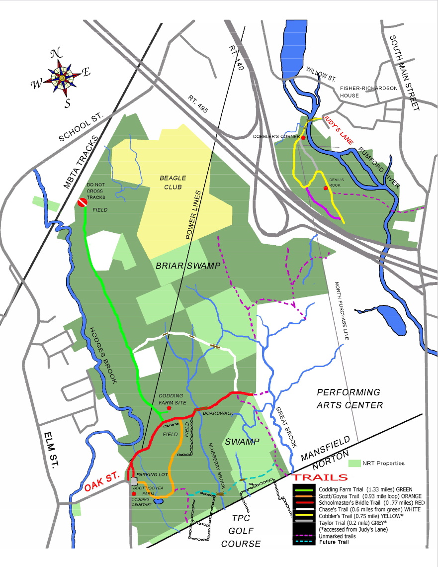
The perimeter of public roads which surrounds the 3.6 square miles of the Great Woods measures 3.9 miles north to south and up to 1.7 miles east to west and is 10.7 miles around. These roads are Route I-495 to the northeast, Route 140 and Freeman Street, Norton, on the east, Route 123 to the south, Oak, Elm, and School Streets in Norton and West Mansfield to the west, and Willow Street in Mansfield on the north. Industrial and housing developments and a large entertainment center deeply notch the Great Woods perimeter. Railroad tracks belonging to MBTA cut across the northwest corner of the area for 0.9 miles.
Three major streams are found within the woods. The Rumford River flows south through the northeast part for 1.6 miles. Hodges Brook flows south for 2.1 miles through the northwest part of the woods. Great Brook has its origin in the Great Woods and flows south its entire length, 2.4 miles, down the center of the forest. These and many tributary brooks comprise about 32 miles of streams within the Great Woods and are part of the Taunton River watershed.
Fifteen miles of trails lace this wilderness, which includes sizable white pine stands with open, pine needle floors, spacious oak forests, acres of brush, impenetrable brier and red maple swamps, abandoned farms, and overgrown woodlots.
The 16 miles of stone walls and the occasional rotting gate post or half-wild apple tree remain to suggest that once the Great Woods harbored an industrious lot of farmers.
The elevation of the Great Woods varies from 104 to 176 feet, the latter being the highest point in Norton. There are no pronounced hills. “Ridge Hill” is a five-mile-long interrupted natural rampart known geologically as an “esker.” Taylor’s Hill, a minor rise in this esker in the northeast part of the woods, has served as a sledding and skiing spot for generations of Mansfield youth.
The Great Woods is frequented by scouts, hikers, hunters, horseback riders, bird watchers, and, more recently, land surveyors.
Until 25 years ago plans to develop the Great Woods failed to mature due to poor drainage and the expenses of meeting building requirements. Since then, however, over 400 acres have been lost to Route I-495, which cuts off the northeast part of the woods, the entertainment center, a trailer park, and other developments. A 400-acre golf course is now under construction across the heart of the Great Woods. Offsetting these losses, 960 acres of woodland in Mansfield and Norton have been set aside as a permanent nature preserve, while within the last year Mansfield rejected a 150-acre amusement park proposed for the eastern side of the woods.
Notable Trails
There are five major and two minor trails in the Great Woods, plus several unmarked trails.
Accessed from the Oak Street entrance are:
The “Schoolmaster Bridle Trail”, marked in red, is 0.77 miles and runs from the Oak Street entrance to the Great Brook. This trail was named for the schoolmasters who used it as a shortcut from Elm Street to South Main Street in the 1800s
The Scott/Goyea Trail, marked in orange, is a 0.93-mile trail that starts at the Oak Street parking lot, meanders through the Scott/Goyea conservation area, and returns, via the red marked trail, to the Oak Street main entrance.
The Codding Farm Trail, marked in green, is 1.33 miles. This trail branches off from the red trail and ends at the railroad tracks. The Codding Farm site can be accessed from this trail.
The Chase Trail (white) runs from the green trail to the red trail near Great Brook.
Parking and the entrance are located at the big bend in the road on Oak Street.
Accessed from the Judy’s Lane entrance are:
The Taylor’s Hill property. The Cobbler’s Trail (yellow) runs past Cobbler’s Corner and onto Taylor’s Hill with a loop back along the Rumford River.
The Taylor Trail (grey) starts just past Cobbler’s Corner, runs parallel to the Rumford River, and rejoins the Yellow Trail at Taylor’s Hill.
The Fisher Trail (purple) starts before Taylor’s Hill and rejoins the Yellow Trail near its end.
Great trails for a short walk!
The AllTrails website has descriptions and maps of hikes at Great Woods Conservation Area.
Content from Official Website