Blue Spring Branch CA

Tips for Birding
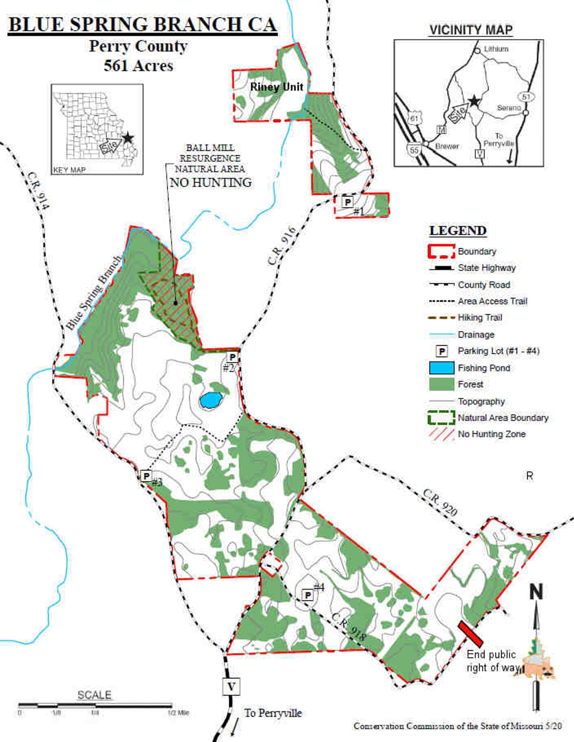
Approaching the area on highway V, one option is to take PCR 918 to the southeast. A short distance from the junction there is a parking lot on a grassy hilltop on the left. A mowed trail leads northeast from here. This is a good spot for observing raptors and other flyover species, and some promising sparrow habitat in season; some of this area will be planted in crops for wildlife, and some will be planted in native grasses and forbs. Continuing southeast 1/10 mile on PCR 918 you reach a wooded bottom; while there is no designated parking area, there is a wide place in the road where it is possible to pull off. A sinkhole pond is in the woods just off the south side of the road, and a rudimentary MDC service road provides a walking trail along the west side of the pond. During migration some warblers are likely here. The opposite side of the pond, to the southeast, is on private land. Just southeast along PCR 918 there is a powerline cut where it is possible to walk in from the north side of the road along the edge of a wooded area.
PCR 918 continues to the southeast, then curves around another sinkhole pond which is just outside the boundary of the conservation area. The road then turns sharply to the northeast. Watch the private farm ground on the right for open-land species such as Savannah Sparrow, Horned Lark, and Northern Harrier. Despite the appearance of online maps, CR918 terminates at the top of a hill about ¼ mile from the curve, and a no trespassing sign marks the point where a private farm lane continues in the same direction (see my note on map). A wooded plot at the extreme east edge of the conservation area is therefore accessible only on foot either from CR918’s end or from CR920, and no maintained trails exist at present.
If you continue straight on PCR 916 at the 916/918 junction, the road winds around the eastern edge of the area for about ½ mile before reaching a service road to the left. It is possible to park here and walk in on the service road to some open ground surrounding a machine storage shed that houses Barn Swallows in summer. The perimeter of this open ground is good for White-crowned Sparrows in winter. There are numerous mowed paths in the area, many of which will be mowed year-round, while others may be mowed only in the fall for hunting. Paths allow access to the edge of woodland to the south, or to a fishing pond to the northwest surrounded by a strip of shrubs and trees. This pond area is a good spot for warblers, vireos, and flycatchers during migration. Continuing north on PCR 916 another 1/8 mile, you reach the parking area for Ball Mill Resurgence Natural Area, a location well worth a visit (see separate Birders’ Guide).
Another option is to take PCR 914 from State Highway V, along the western edge of the area. About ½ mile from the junction there is a parking area that provides access to the other end of the service road accessible from PCR 916. At this end of the service road, numerous mowed paths allow access to the grasslands and small wooded sinkholes.
Birds of Interest
Woodland and grassland species are found throughout, and there are high points that are well suited for watching raptors. Numerous warbler and sparrow species have been observed here.
About this Location
This conservation area has been greatly enlarged starting in 2017, and now includes about 560 acres. The area encompasses a large area of former agricultural land and woodland, all of it on Perry County Karst topography, filled with sinkholes, resurgences, springs, and rocky barrens. There are numerous sinkhole ponds, and dry sinkholes provide islands of tree cover in grasslands. Larger wooded patches and small stream drainages provide habitat for woodland species.
Blue Spring Branch CA now includes Ball Mill Resurgence as a designated Natural Area within its boundaries (see birders’ guide for Ball Mill Resurgence). Ball Mill Resurgence is also an eBird hotspot, separate from the Blue Spring Branch CA hotspot.
Notable Trails
There are variable mowed paths in the grassland/prairie areas which may be walked, but are not formal trails.
There is a trail in the Riney Unit, accessed from a parking lot 3/4 mile north of the main portion of the area on PCR 916. From this lot, a mowed trail leads northeast across a grassy hilltop, which can be a good spot for winter sparrows, to a service road/trail that descends westward through some rocky hillsides, terminating at Blue Spring Branch itself. The varied terrain on this steep, rocky trail includes some shrubby old-field succession land with Bell’s Vireo possible, as well as widely spaced mature trees and denser woodland, with a small tributary stream paralleling the trail on the south side. The trail terminus at Blue Spring Branch can be an excellent spot for warblers during migration.
Features
Roadside viewing
Restrooms on site
Wheelchair accessible trail
Entrance fee
Content from A Birders' Guide to Blue Spring Branch CA
Last updated January 13, 2024
 Blue Spring Branch Conservation Area map
Missouri Dept. of Conservation