Cave Hill Conservation Area
Cave Hill Conservation Area
Leverett, Massachusetts 01054
Official WebsiteCave Hill Conservation Area map
About this Location
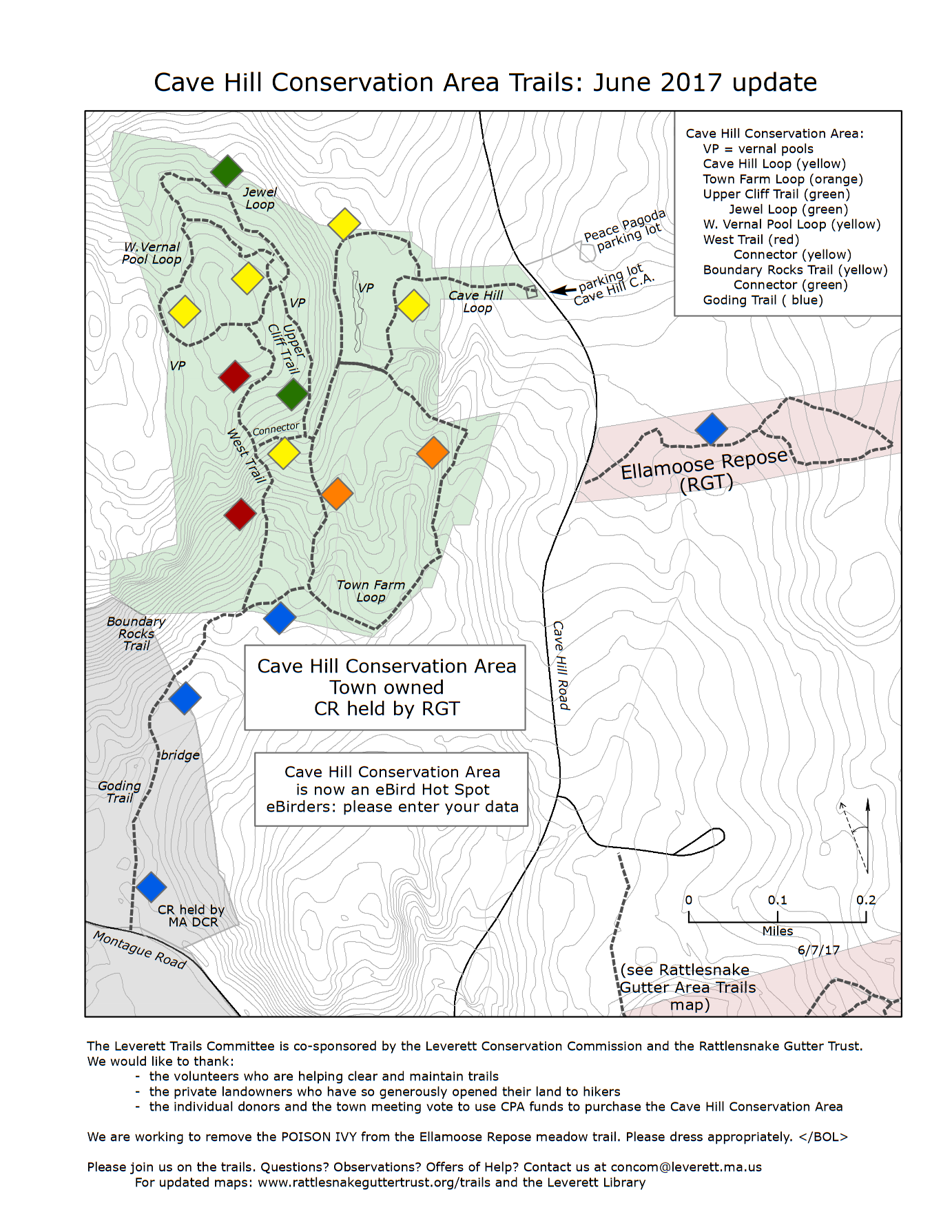
The 102-acre Cave Hill Conservation Area was purchased in 2014 by a town meeting with funds from the Community Preservation Act and private contributions from 127 households. It is owned by the town. The Rattlesnake Gutter Trust holds the Conservation Restriction. The best-known part of the property is a series of parallel north-south cliffs, but there are also 3 certified vernal pools, seasonal streams flowing both north and south that feed Cranberry Pond, wetlands, a network of trails, and a long land-use history including several stone structures of both historic and ceremonial origin. The property was once part of the Leverett Town Farm (1866-1890). This map shows the former boundary of the town farm.
The trails include new-growth forests from recent logging, older forests, certified vernal pools, wetlands, seasonal streams, cliffs, and rock clusters. The trails are also a geologic trip back to a continental suture between two of the blocks that now make up the North American continent. Three new trails were added in the fall of 2015.
The eastern section of the Cave Hill Conservation Area is part of the Gander Terrane, which is a microcontinent that at one time was located north of Africa. The Poplar Mountain Gneiss and the Dry Hill Gneiss both formed about 600 million years ago on the Gander Terrane. The Gander Terrane collided with North America around 430 million years ago.
?The western part of the Cave Hill Conservation Area has rocks that were never a part of the Gander Terrane but rather formed here in North America. These volcanic and sedimentary rocks were deeply buried and deformed around 380 million years ago when yet another continental collision added to North America the rocks upon which Boston is now built. These rocks belong to the Ordovician (about 450 million-year-old) Four-Mile Gneiss and Partridge Formations, and the Devonian (about 410 million-year-old) Erving Formation.
The boundary between the eastern and western parts of the property is part of the boundary between these two blocks that make up part of the North American continent. The fact that a continental suture is exposed within this area makes it a hugely valuable site for study by local geologists and geology students.
Notable Trails
The AllTrails website has a description and map of a hike at Cave Hill.
Features
Restrooms on site
Wheelchair accessible trail
Entrance fee
Content from Official Website
Last updated December 3, 2023