Fourth Connecticut Lake, Pittsburg
Fourth Connecticut Lake, Pittsburg
The Nature Conservancy Pittsburg, New Hampshire 03592
Official WebsiteFourth Connecticut Lake map and guide
Connecticut Region map
Tips for Birding
If you carefully keep your bird records by country and state or province, be aware of the location of the United States-Canada border and use the appropriate eBird hotspots when you submit checklists.
About this Location
Nestled just below the ridgeline that separates New Hampshire from Quebec, Fourth Connecticut Lake marks the beginnings of New England’s longest river. More than 400 miles long, the Connecticut River is also the largest watershed in the region, draining nearly 12,000 square miles of New Hampshire, Vermont, Massachusetts, and Connecticut, where it enters the ocean at Long Island Sound.
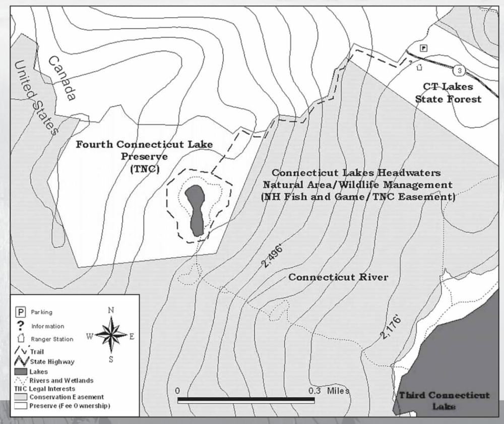
Fourth Connecticut Lake Preserve symbolizes the importance of the Connecticut River watershed while protecting important boreal habitats. At 78.1 acres, the preserve is surrounded on the United States side by an additional 4,900 acres protected by a conservation easement held by The Nature Conservancy and owned by the state of New Hampshire (part of the Connecticut Lakes Headwaters Natural Area).
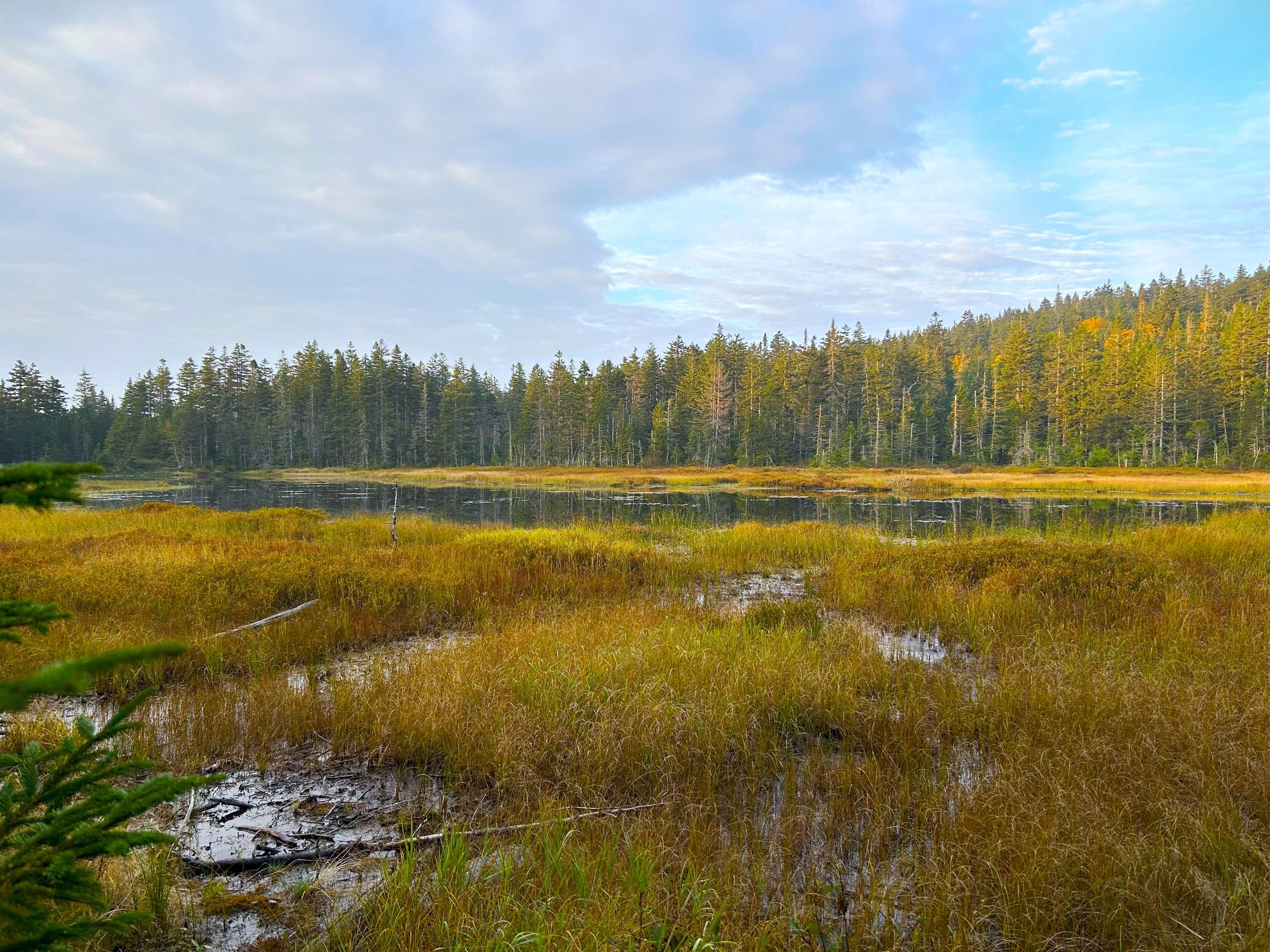
The forest in the preserve is thick with balsam fir and peppered with red spruce, paper birch, and mountain ash, making it an ideal habitat for boreal birds like the northern three-toed woodpecker and spruce grouse, as well as woodland wildflowers like wood sorrel, bunchberry, creeping snowberry, and lady’s slipper. At 2.5 acres in size, the lake itself is considered a northern acidic mountain tarn, a small pond created by glacial action during the last ice age. Though shallow (it has a maximum depth of 5 feet) the pond does not completely freeze in winter and supports a small year-round fish population, river otter, and beaver.
About Connecticut Lakes
See all hotspots at Connecticut Lakes
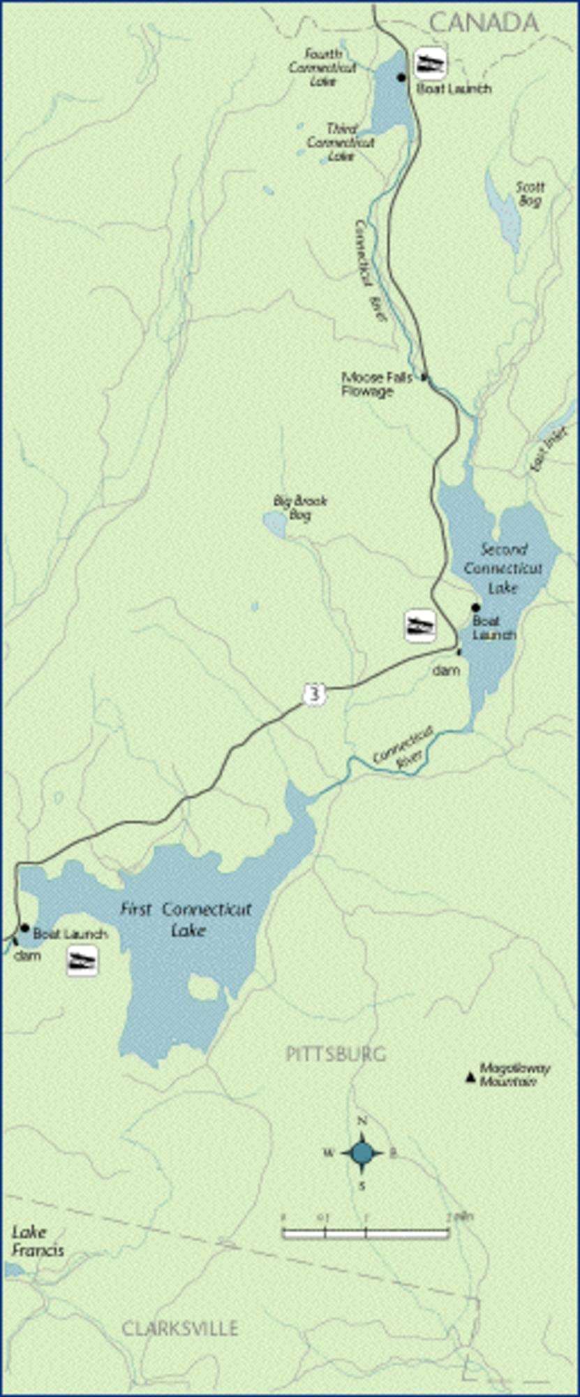
High in the mountains of New Hampshire, you’ll find the Connecticut Lakes and headwaters of the Connecticut River. Starting as just a trickle in the small town of Pittsburg, the Connecticut River flows through a chain of lakes, the Connecticut Lakes, as it makes its way from the US-Canadian border in New Hampshire to Long Island Sound. Its journey of 400 miles begins at the height of land, becomes the diving border between Vermont and New Hampshire, then flows through the industrial valley of Massachusetts and into Connecticut before finding the sea.
The lakes are accessed via the northernmost segment of US-3, between the village of Pittsburg and the Canada port of entry south of Chartierville, Quebec. The lakes are located within the boundaries of Pittsburg but are far from the town center.
The lakes are popular destinations for fishing, boating, and wildlife viewing. The area is also home to several lodges and campgrounds that cater to outdoor enthusiasts. The lakes are surrounded by the Connecticut Lakes State Forest and are near the Lake Francis State Park. The area offers views of the mountains and forests, as well as opportunities to spot moose, deer, bears, and other animals.
The Connecticut Lakes are named after the river they feed, which in turn was named after an Algonquian word meaning "long tidal river". The lakes are numbered from south to north: First Connecticut Lake is the largest and deepest; Second Connecticut Lake is slightly smaller and shallower; Third Connecticut Lake is the smallest and most remote; and Fourth Connecticut Lake is the source of the Connecticut River, located just south of the Canadian border. The lakes have a combined surface area of about 2,660 acres and a maximum depth of 163 feet at First Connecticut Lake.
Notable Trails
The trail to Fourth Connecticut Lake heads west along the United States-Canada border, at times climbing steeply. Please be sure to watch your footing. At 0.4 mile you will come to the preserve corner and eastern boundary. Remain on the international boundary trail another 0.1 mile until you come to the place where the Conservancy’s trail drops south from the international boundary. Follow this trail 0.1 miles to the north end of the lake, where you may choose either direction for a 0.5-mile loop walk around the entire water body. At the south end of Fourth Lake, you will literally step over the Connecticut River as it begins its great journey southward. Your return along the international boundary trail will be easier, but watch your footing in steep and wet places. Take time to enjoy the views of the surrounding landscape as you crest the last knoll before the end of the trail. The entire round trip is 1.7 miles and usually takes about 2 hours.
Features
Restrooms on site
Wheelchair accessible trail
Entrance fee
Content from Official Website and Fourth Connecticut Lake guide
Last updated November 20, 2023