Organ Mountains-Desert Peaks NM--Aguirre Spring RA Entrance Road
Organ Mountains-Desert Peaks NM--Aguirre Spring RA Entrance Road
Organ, New Mexico 88052
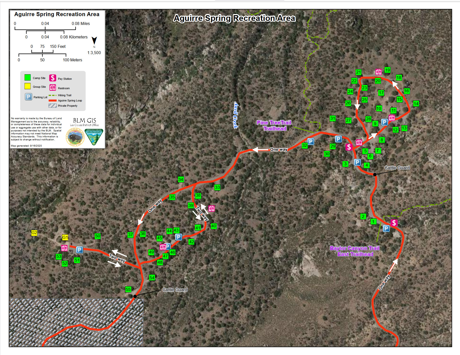
Official WebsiteAguirre Spring Recreation Area map
Aguirre Spring Recreation Area brochure and hiking guide
Organ Mountains-Desert Peaks National Monument Official Website
Organ Mountains-Desert Peaks National Monument brochure and map
Tips for Birding
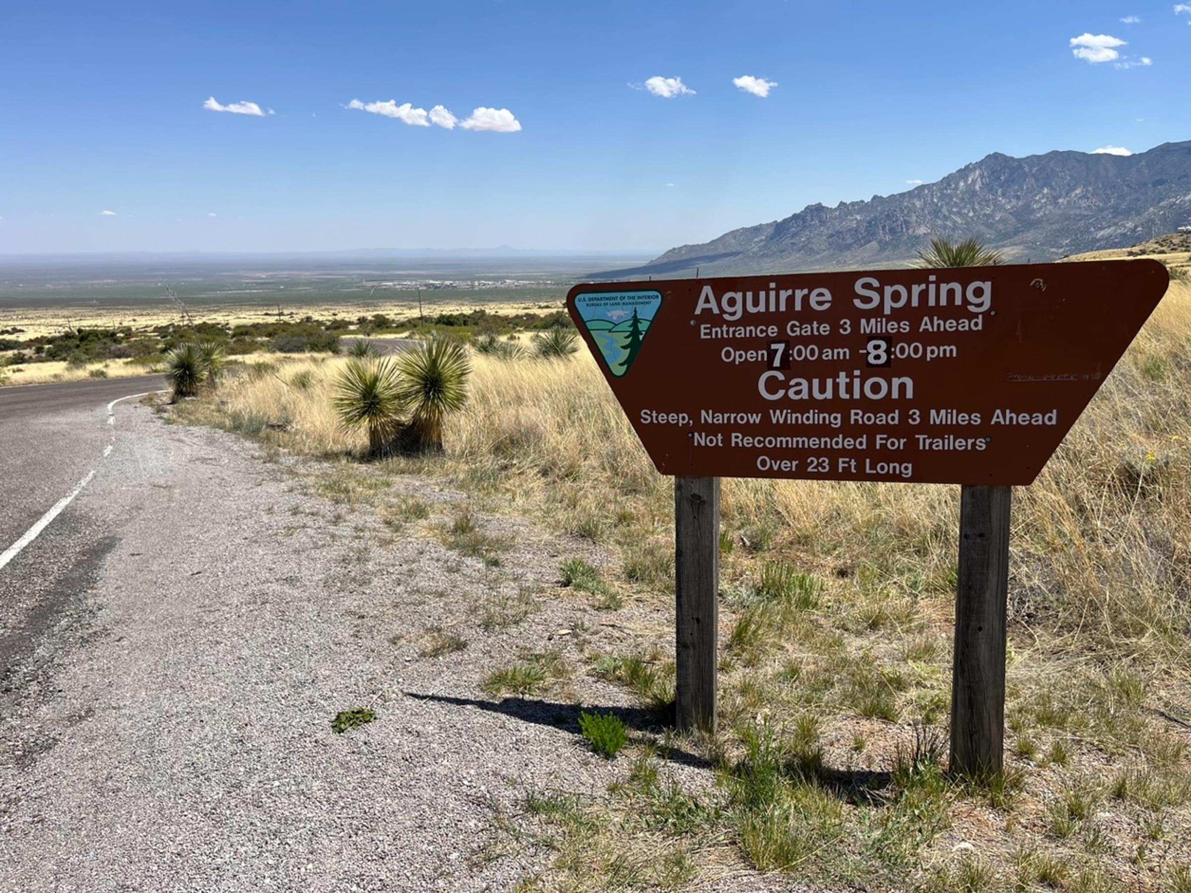
The north end of this hotspot is located where Aguirre Spring Road heads south from US-70. Strictly, the south end of the hotspot would be three miles along this two-way road at the recreation area entrance gate but may have been extended in some lists to a point about a mile further where the road becomes a one-way loop through the campground. The entrance road, running between the Organ Mountains Wilderness on the west and White Sands Missile Range on the east, is fenced, with few pull-outs. This is 100% roadside birding.
Birds of Interest
The arid grassland on both sides of the road is dotted with sotol and mesquite, providing a habitat for Chihuahuan Desert bird species.
About this Location
Aguirre Spring Recreation Area
The high wall, needle-like spires of the Organ Mountains curve dramatically around a semicircle of Chihuahuan Desert habitat at the Aguirre Spring Campground. The campground, nestled at the base of spectacular cliffs, overlooks the Tularosa Basin and White Sands National Park. Alligator juniper, gray oak, mountain mahogany, and sotol are a few of the abundant plant species here. Seasonal springs and streams occur in the canyon bottoms, with a few perennial springs that support riparian habitats.
Entrance Gate Hours (change with Daylight Savings Time)
Winter Hours (November – March): 8:00 a.m. – 6:00 p.m.
Summer Hours (March – November): 7:00 – 8:00 p.m.
The Aguirre Spring Recreation Area and Campground are located on the east side of the Organ Mountains, east of Las Cruces in Dona Ana County. Take US-70 for 14 miles east of the I-25/US-70 interchange in Las Cruces, then turn south on the Aguirre Spring Road (1.1 miles after San Augustine Pass) for six miles. At mile 4 the road becomes a one-way loop and climbs steeply.
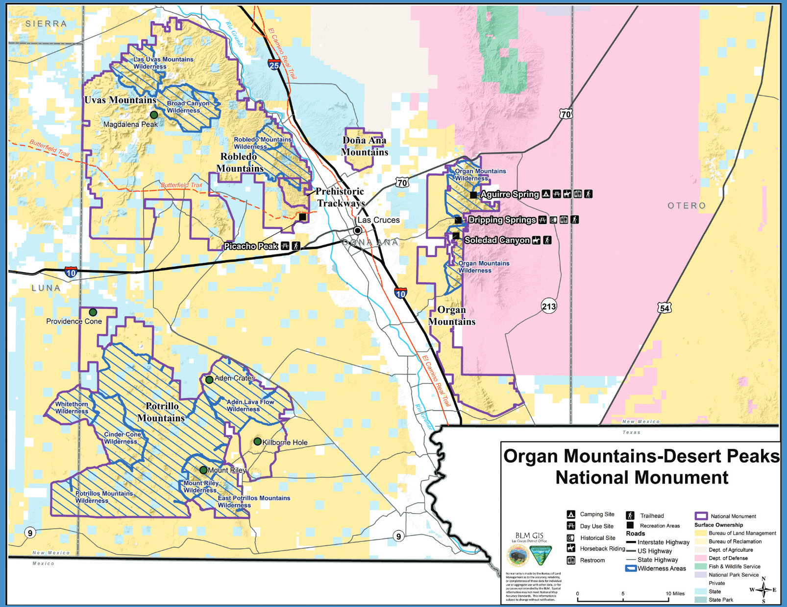
About Organ Mountains-Desert Peaks National Monument
See all hotspots at Organ Mountains-Desert Peaks National Monument
The Organ Mountains-Desert Peaks National Monument was established to protect significant prehistoric, historic, geologic, and biologic resources of scientific interest, and includes four areas: the Organ Mountains, Desert Peaks, Potrillo Mountains, and Doña Ana Mountains.
The Organ Mountains are a steep, angular mountain range with rocky spires that jut majestically above the Chihuahuan Desert floor to an elevation of 9,000 feet. This picturesque area of rocky peaks, narrow canyons, and open woodlands ranges from Chihuahuan Desert habitat to ponderosa pine in the highest elevations. Located adjacent to and on the east side of Las Cruces, this area provides opportunities for photography, hiking, horseback riding, mountain biking, camping, and wildlife viewing.
The Desert Peaks include the Robledo Mountains, Sierra de las Uvas, and Doña Ana Mountains, characterized by desert mountains rising steeply from flat plains.
The Potrillo Mountains are the most remote section of the Monument located a distance to the southwest from Las Cruces and are comprised of a volcanic landscape of cinder cones, lava flows, and craters.
The Doña Ana Mountains have extensive pedestrian trails, equestrian trails, mountain bike trails, rock climbing routes, and some limited routes available for motorized use.
Features
Entrance fee
Roadside viewing
Restrooms on site
Wheelchair accessible trail
Content from Official Website, Organ Mountains-Desert Peaks National Monument Official Website, and John Montgomery
Last updated April 26, 2023