Goldsmith Reservation
About this Location
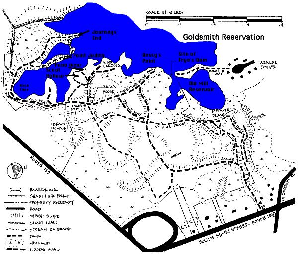
At the Goldsmith Reservation, 170 acres, a trail extends to the very tip of Bessie's Point. Just across a narrow channel, there's another peninsula that can be reached from Azalea Drive. Between the tips of the two peninsulas lies the granite base of a colonial dam. The water is quite shallow, and a canoe paddle plunged into the channel can touch the old slab.
To the east of the ancient dam site, the cove is named the Old Mill Reservoir. At about 15 feet, it is the deepest part of Foster's Pond, dredged in the late 1960s for gravel. If you look carefully, you may be able to spot on the far shore the yellow flags marking the greens of Foster's Pond National Golf Course - the ingenious backyard 9-hole layout of a former resident, maintained by the current owner. There are three small greens, with a total of 9 different tees strategically located around the Old Mill Reservoir.
Some of the trees, rhododendrons, and laurels growing along the roadway in Goldsmith Woodlands were planted by Bessie Goldsmith herself. Note the avenues of white pines, so dense that few plants can grow beneath them. The yellow lady slippers are in bloom here in late spring. Other plants rarely seen are visited by Harvard University botanists. The marshes adjacent to the pond are home to cattails, loosestrife, pitcher plants, and blue herons.
Parking is on South Main Street (MA- 28) near Gould Road. the main trail from MA-28 toward the pond passable by wheelchairs.
Notable Trails
The AllTrails website has a description and map of a hike at the Goldsmith Reservation.
Features
Wheelchair accessible trail
Restrooms on site
Entrance fee
Last updated May 5, 2024