Cass Meadow Conservation Area
Cass Meadow Conservation Area
Athol, Massachusetts 01331
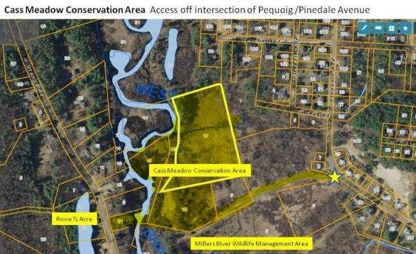
Official WebsiteCass Meadow Conservation Area map
About this Location
Cass meadow is composed of floodplain meadows covering more than 100 acres along the Millers River in Athol. Active farmland for decades the rich soils produced corn and hay for the Cass Dairy. Over time the dairy closed and the farmland was sold. Currently, this section of the meadow consists of 3 main parcels of land owned by the Mass Division of Fisheries and Wildlife, the Town of Athol, and a private landowner who has graciously allowed the maintenance of paths through the meadow. A cooperative agreement has been in place providing the local citizens access to Millers River and the meadow's wonderful wildlife while maintaining the habitat for species of concern to the wildlife agency.
From Athol Center, go north at traffic light onto Exchange Street, cross a bridge, and turn left onto Pequoig Avenue. Continue about 0.5 miles to the entrance on the left.
Features
Restrooms on site
Wheelchair accessible trail
Entrance fee
Content from Official Website
Last updated December 8, 2023