Heath Hen Meadow
About this Location
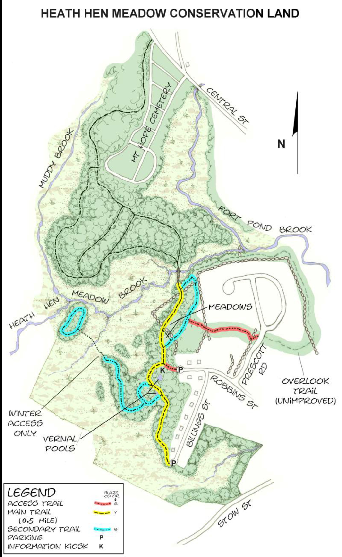
Heath Hen Meadow Conservation Land, comprising wetlands, streams, meadows, and upland woods, together with Heath Hen Meadow Brook, which forms its northern boundary, takes its name from a once-abundant, partridge-like relative of the prairie chicken that became extinct early in the 20th century. The brook rises in Stow, picks up the Muddy Brook tributary at the western boundary, and merges with Fort Pond Brook near the eastern boundary. The wetlands acreage is extensive, comprising two-thirds of the property.
The main entrance is from the Robbins Street cul-de-sac via a short, red access trail, which joins the main straight-through trail at its midpoint. From its southern end at the Billings Street cul-de-sac, the trail winds through woods of mature white pines behind the houses on Billings Street, passing two prominent vernal pools. After intersecting the red access trail, the main trail continues through two meadows and another small woodland before reaching its northern terminus at Heath Hen Meadow Brook.
A footbridge built by Land Stewardship volunteers spans Heath Hen Meadow Brook, joining Heath Hen Meadow Conservation Land with the Mount Hope Cemetery woodland beyond. The cemetery and woodland are also town-owned lands, and pedestrian access to the wooded area is possible from the back of the cemetery. A portion of the loop trail through this woodland skirts the edge of wetlands, while a shorter inner loop passes through upland woods. These trails are unblazed. On the upstream side of the bridge a large, seemingly permanent, beaver dam has significantly increased the extent of the wetlands above it. Below the dam, the streambed is narrow but can be reached by canoe from a put-in at the Maple Street crossing of Fort Pond Brook near Jones Field.
Heath Hen Meadow is home to a variety of wildlife including beaver, skunk, raccoon, opossum, deer, ducks, partridge, and an occasional blue heron. The meadows and surrounding woods provide habitat for numerous species of songbirds and raptors, as well as insects and amphibians.
Entrances to Heath Hen Meadow:
- Cul-de-sac on Robbins Street, off Stow Street (Parking, Kiosk)
- End of Billings Street, off Robbins Street (Parking on-street)
- West side of Prescott Road, off Robbins Street
- Central Street, north side of Mount Hope Cemetery
- The rear of Mount Hope Cemetery (Parking)
Notable Trails
One of the property’s two blue secondary trails leaves the westerly side of the main trail at two points along the Billings Street segment. From this short loop, it winds through moist woodlands, along an esker, and ends seasonally at the edge of the wetlands. When frozen during the winter, the wetlands may be crossed to a small island, probably originally an extension of the esker, that the trail encircles. When accessible, this island is an excellent place for viewing the marsh birds that inhabit the broad marsh.
The other secondary trail leaves the main trail at the southern end of the upper meadow and rejoins the main trail north of the lower meadow, near the Heath Hen Meadow Brook crossing. This blue trail passes through the remains of a former apple orchard and for most of its distance runs close to picturesque stone walls. The red access trail from Prescott Road intersects it near its midpoint. Both red and blue trails follow part of the remains of an old carriage path. Some of the stonework in this area appears to have lined this carriage route.
Features
Restrooms on site
Wheelchair accessible trail
Entrance fee
Content from Official Website
Last updated December 28, 2023