Gallinas River, Prince Street through Roundhouse Woods
Gallinas River, Prince Street through Roundhouse Woods
Las Vegas, New Mexico 87701
Gallinas River Park Official WebsiteCinder Road River Trail (TrailLink) webpage
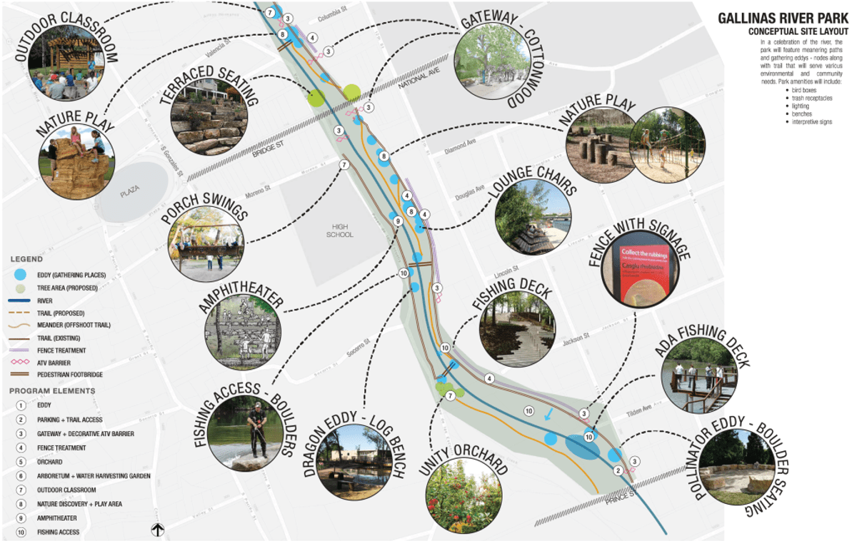
Gallinas River Park concept map
Tips for Birding
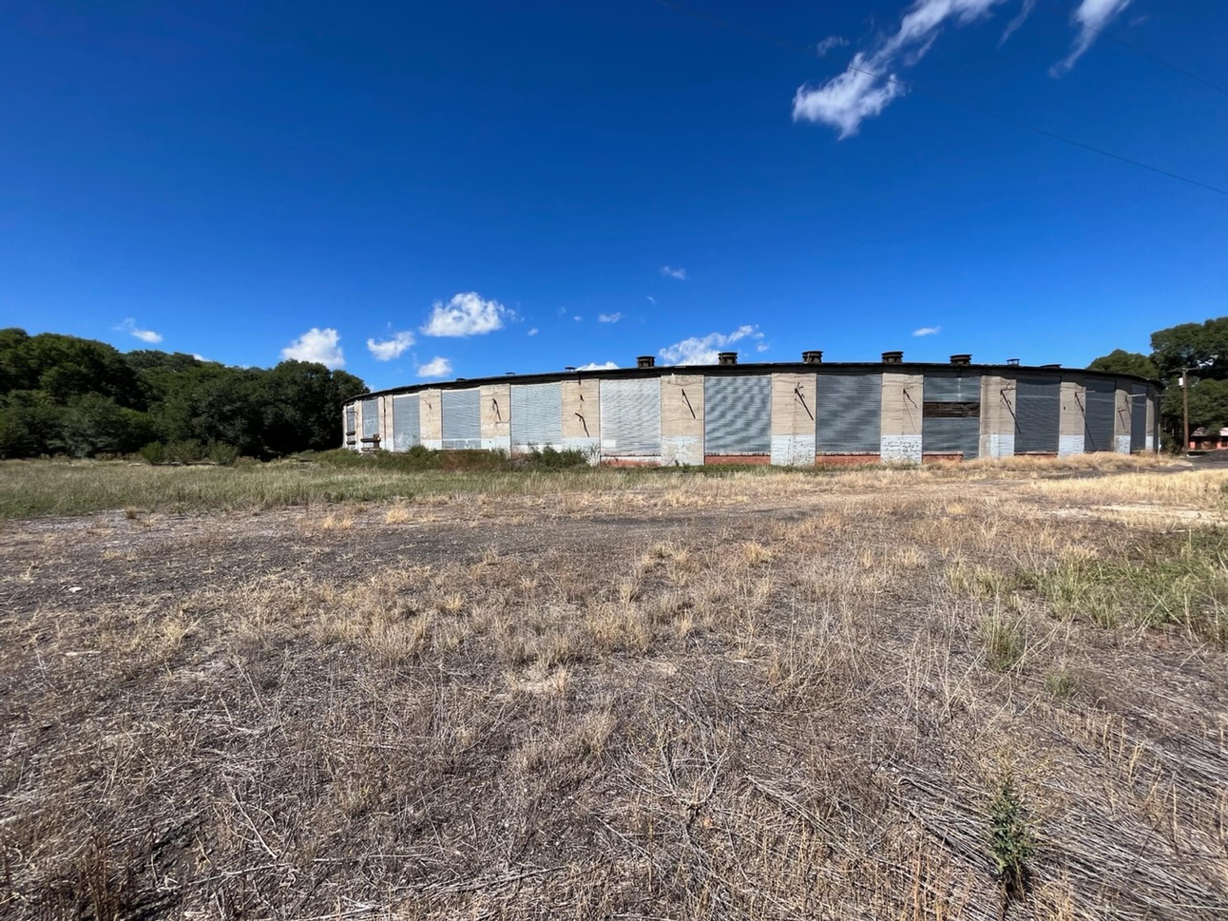
The southernmost point of the Gallinas River Park trail that is developed is on the north side of Prince Street. There is a gravel parking area on the northeast side of the Prince Street bridge across the creek. On the other side of Prince, a narrow dirt path leads an eighth of a mile southeast, at the edge of the elms lining the east side of the creek, to Grand Avenue (Business I-25). You cross Grand, while the creek flows underneath. The path, wider now, enters a wood (again, almost entirely of elm) west of the old Atchison, Topeka, and Santa Fe Railway roundhouse. Immediately south of Grand, the creek bifurcates, with the path meandering between the two waterways. The woods and path extend another fifth of a mile southeast to the still-used railroad tracks, south of which lies ranchland; the trestle over the creek marks the south end of the hotspot. Often, particularly by late summer, the creek is very narrow and shallow here, so you can easily cross to the west side, coming back through the woods to Grand on that side of the creek. You can continue northwest on that side by walking River Road back to Prince; this is the only portion of the hotspot that would allow roadside viewing.
It is possible to do this route in the opposite direction, or even to start near the roundhouse; however, the path is much clearer north-to-south, traveling clockwise. The woods are a favorite camping area for unhoused persons, as well as for presumably housed persons dumping all manner of trash.
Birds of Interest
Broad-tailed Hummingbird, Olive-sided Flycatcher, Evening Grosbeak, Virginia’s Warbler, and Black-throated Gray Warbler have been reported on multiple lists for this hotspot.
About Gallinas River Park
See all hotspots at Gallinas River Park
Gallinas River Park
In 2016 Hermit’s Peak Watershed Alliance teamed up with the (then) Las Vegas-San Miguel Economic Development Corporation to spearhead the revitalization of the Gallinas River Park in downtown Las Vegas. A group of collaborators was formed consisting of many businesses, government entities, and community organizations to begin transforming the Gallinas River Park from an underused and abused park into the centerpiece of our town. The vision was for it to be a natural refuge and recreation resource that honors local river heritage while supporting a healthy river ecosystem and a vibrant community.
Since then, significant work has been done to realize this dream to the credit of the many players that have been involved. This significant project, estimated at $6.5 million, will take a collaborative effort by many Las Vegas organizations and people. Now, the Friends of the Gallinas River Park, a program of the Hermit’s Peak Watershed Alliance working closely with the City of Las Vegas, continues to coordinate and facilitate the revitalization of the Gallinas River Park and its long-term management and maintenance.
Gallinas River
The Gallinas River, also known as Rio Gallinas, is a river in northern New Mexico that flows into the Pecos River. The Gallinas River originates as Gallinas Creek in the Santa Fe National Forest, with headwaters near Elk Mountain, flowing generally northeast to southwest through San Miguel County. It passes the northern base of Johnson Mesa before exiting the national forest west of the E.V. Long Campground hotspot. The city of Las Vegas protects the creek directly upstream of the Montezuma Skating Pond in order to provide drinking water for the residents. Las Vegas has developed a park along the creek through the city, although flow is reduced due to water being diverted above the city to Storrie Reservoir, from where irrigation water is released, eventually passing into Las Vegas National Wildlife Refuge. Water that leaks under the Storrie Reservoir dam flows down Arroyo Pecos, rejoining the creek southeast of the city, forming the Gallinas River, the western boundary of the wildlife refuge. The Gallinas River was listed as one of America's most endangered rivers in 2023 by American Rivers, a conservation organization.
Features
Roadside viewing
Restrooms on site
Wheelchair accessible trail
Entrance fee
Content from Gallinas River Park Official Website, Cinder Road River Trail (TrailLink) webpage, and John Montgomery
Last updated October 5, 2023