Great Esker Park
About this Location
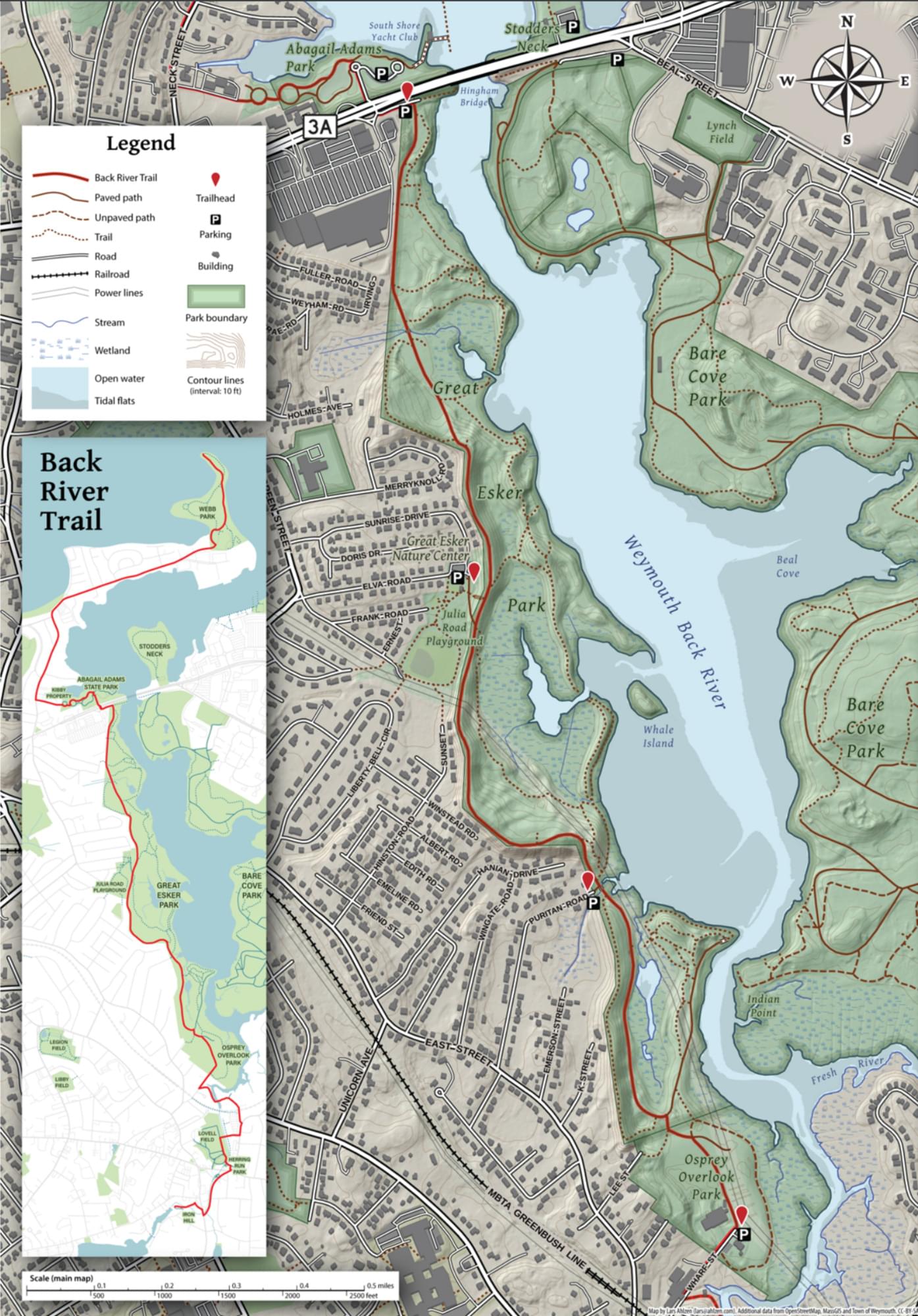
Great Esker Park is a forest-covered gravel ridge and an expansive salt marsh along the Weymouth Back River. Over 6 miles of paved and unpaved trails. Paved trails are stroller-friendly. Beautiful views of the estuary. Launch your canoe or kayak at higher tides at the Puritan Road entrance. Links directly to Julia Road Park and Osprey Overlook Park. Part of the Back River Trail.
Great Esker Park, established in 1966, is Weymouth’s largest open space area. Its most remarkable feature is the esker itself, a long, winding ridge that borders the Back River. At 90 feet in height, it is the tallest esker ridge in North America. It was created by a retreating glacier 12,000 years ago. The same glacial retreat deposited the enormous boulders at Weymouth’s House Rock Park.
One of many properties linked by the Back River Trail, Great Esker Park directly abuts Abigail Adams State Park and Osprey Overlook Park, as well as Julia Road Park. Motorized vehicles are prohibited. Trail, signage, and access improvements are currently underway.
The Weymouth Back River is also known simply as the Back River. Both Native American and European settlers relied on it as a source of food, particularly river herring. In 1982, the Weymouth Back River received the state designation of Area of Critical Environmental Concern (ACEC), “a place in Massachusetts that receives special recognition because of the quality, uniqueness, and significance of its natural and cultural resources.”
Around 1635, European settlers in Hingham and Weymouth established the Back River as the boundary between the two towns. In later years, the river was home to several industries, including a steel mill, a wool factory, and a fertilizer factory. In 1912, the Army Corps of Engineers dug a large channel from the river mouth to the fertilizer factory, deepening and widening the river. A similar project deepened the channel in 1943.
Great Esker Park was originally preserved by the U.S. government. It served as a buffer for the U.S. Naval Ammunition Depot (1903-1971), across the river in Hingham (today’s Bare Cove Park). Military patrols would make use of the high vantage points along the esker ridge to guard the base below. It was sold to the Town of Weymouth, for use as a park, in 1965, through the National Park Service’s Federal Lands to Parks Program. This was due in large part to the advocacy work of local environmentalist Mary F. Toomey. Toomey founded the Great Esker Park Natural Science Center in 1966 and continued to advocate for the Back River throughout her life. She is commemorated on a colorful sign posted on one of the park’s overlooks.
At Great Esker Park, you can enjoy a direct experience with the tidal salt marsh that borders the Weymouth Back River. Some of the park’s trails lead along the bottom of the ridge, at the edge of the marsh. In season, look for ospreys. There are two active nest platforms within the park. It is also common to see egrets. Look for river herring swimming upstream in the springtime.
The forest that grows on top of the ridge is composed of oak, birch, and cedar, with some sumac, maple, and pitch pine. Kettle Hole Pond was formed by a melting chunk of glacial ice. Directly across the river is another excellent place to explore, Bare Cove Park in Hingham.
According to the signage within the park, “An esker is a long ridge of sediment and gravel left behind after the retreat of a glacier. Eskers are formed when meltwater channels running under a glacier deposit sediment gravel along the way. After the glacier completely retreats, this sediment ridge is left. At a height of 90 feet, these eskers are considered to be the tallest in North America.”
The Weymouth Back River rises from several ponds and swamps, including Whitman Pond in Weymouth. It flows for about 10 miles, and empties into the Atlantic Ocean at Hingham Bay, downstream of the park, and just south of Grape Island and Slate Island.
Notable Trails
A wide paved trail extends for about 2 miles along the top of the esker ridge from Bridge Street to Osprey Overlook Park. In general, it is stroller and wheelchair-friendly, although portions are hilly and steep. There is also an expansive network of narrower, unpaved trails through the woods and along the edge of the salt marsh. In total, Great Esker Park offers 6.3 miles of trails.
The Bridge Street (MA-3A) entrance is directly across the street from the entrance to Abigail Adams State Park, very close to the Harbor Medical building. Although parking is limited, this is the most forgiving access point, as it is situated at the top of the esker ridge. On the other hand, the Elva Road entrance offers ample parking, but it is situated below the ridge, and thus a steep uphill hike is required to reach the trails!
The AllTrails website has descriptions and maps of hikes at Great Esker Park.
Content from Official Website