Sanford Farm
About this Location
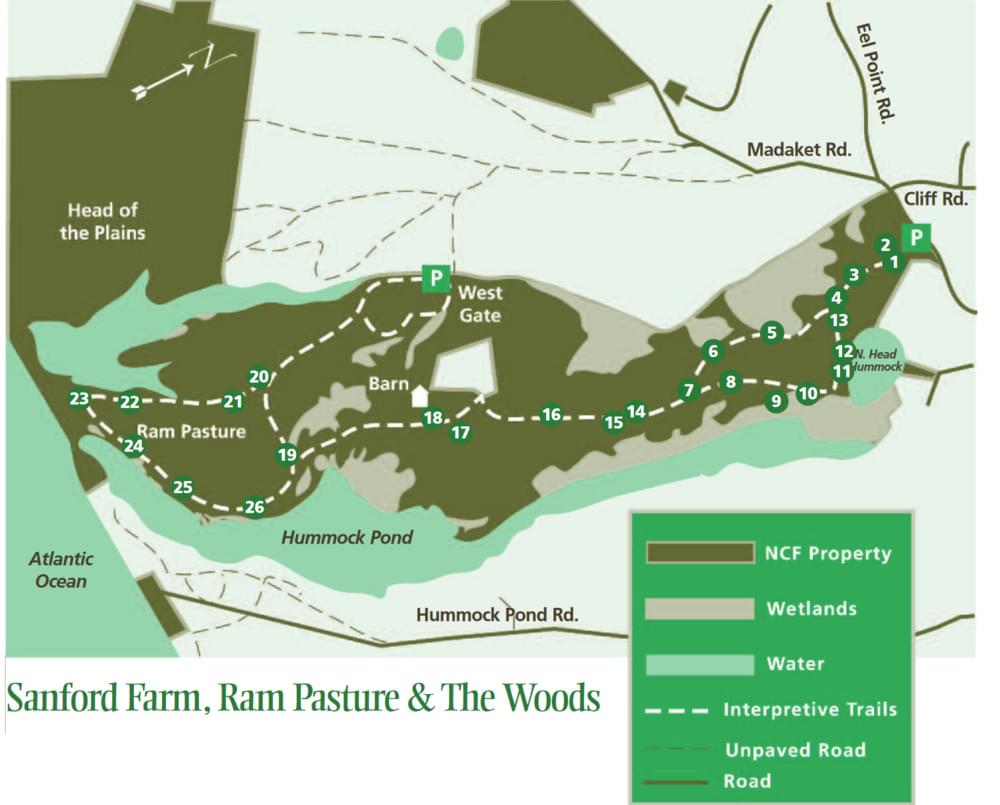
One of our best-known and most popular properties, this 780-acre property consists of 3 contiguous properties: Sanford Farm, Ram Pasture & The Woods. This region of Nantucket was part of approximately 29,000 acres on the island that was set aside as “common land” by the 27 original shareholders, who settled in Nantucket in 1659. It was used during the 17th and 18th centuries by these settlers and their descendants for grazing sheep and cows, farming, and harvesting wood. Sanford Farm is now best known for its popularity with walkers, runners, dog owners, and bicyclists for its well-marked trails, spectacular vistas, ocean views, and a respite from the hustle and bustle of nearby Town.
Highlights of the property are the great views of North Head and Hummock Ponds, the sandplain grassland area at Ram Pasture, and the spectacular undeveloped beach at the southern boundary. A historic barn is located near the middle of the property on a hill that offers excellent views of the southern part of the property.
The Sanford Farm
The northernmost portion of this conservation area is known as Sanford Farm. Beginning in 1985, the Nantucket Conservation Foundation and the Nantucket Islands Land Bank Commission (a county-level governmental agency) participated in a cooperative effort to purchase 300 acres of the property once owned by Mrs. Anne W. Sanford from the beneficiaries of her estate for $4.4 million to protect the land from the threat of development. The western portion of this tract, known as West Sanford Farm, contains 166.5 acres that are now owned by the Land Bank Commission, while the Sanford Farm contains 133.5 acres that are owned by the Nantucket Conservation Foundation.
Sanford Farm was an operating dairy farm up until the early 1920s. The remains of a silo are located on a small hill on the western side of the property and mark the former location of a barn and farmhouse. It was last farmed by Randolph Swain, who later sold the property to Charles and Anne Kimball (later known as Anne Sanford) in the 1930s. Mrs. Sanford had the stone house across from the Head of Hummock Pond built as a replica of an English farmhouse from her native country. She was a staunch supporter of the Foundation’s work and one of its founding members. The property is now named in her memory.
Ram Pasture and The Woods
Bordering the Sanford Farm to the south are 634 acres of property collectively known as Ram Pasture and The Woods. Purchased in 1971 for $625,000, this area was the object of the Foundation’s first fund-raising campaign. Although the property had attracted the attention of developers in the late 1960s, the owners at the time Harold E. Anderson, Robert D. Congdon, Ernest H. Menges, and Albert L. Silva, Sr. elected to sell it to the Foundation for a price that was well below market value.
Ram Pasture was formerly known as “Nanahuma’s Neck,” named for the Native American Sachem (chief) who lived there in the 1600s. The name “Ram Pasture” came from the practice of using the lower part of the peninsula for grazing rams to keep them isolated from ewes. This management practice controlled breeding to ensure that no lambs were born during the coldest winter months. The rams were herded to the pastures from other grazed lands along the south shore of the island over a bridge that once spanned the narrowest portion of the east branch of Hummock Pond.
Historic names for the area located between Ram Pasture and Sanford Farm include “The Long Trees,” “Long Woods,” and “The Woods,” which refer to the dense trees and shrubs found in the vicinity of Trots Swamp. Due to high amounts of clay in the soil of this region, it is poorly drained and moist throughout much of the year. Species that are adapted to growing under these conditions occur here, including hawthorn, swamp azalea, sweet pepperbush, shadbush, and highbush blueberry.
Directions
From town, drive west on Madaket Road for approximately 1.5 miles. The parking lot is on the left and is surrounded by post and rail fencing. There is abundant parking at the entrance and the trails are marked. While the area near the entrance and the North Head are quite popular, visitors who travel to the southern half of the property are more likely to see deer and osprey than other people. There is an information kiosk at the main trailhead but there are no restroom facilities at Sanford Farm.
Habitat
It was Nantucket’s long history of grazing and farming that created the unique vegetation communities that are well-represented on this property. The clearing of fields for agriculture and constant grazing pressure from sheep and cows removed trees and tall shrubs, thus allowing grasses, sedges, wildflowers, and low shrubs to proliferate once farming practices ceased. Consequently, this area of the island now supports some of the best examples of sandplain grassland and sandplain heathland habitats on Nantucket. Sandplain grasslands are characterized by open, grassy plains interspersed with small patches of low-growing shrubs and herbaceous plants. Sandplain heathlands contain many of the same plant species as the grasslands but have a larger component of shrubs.
Sandplain habitats support ecologically significant concentrations of rare and endangered plants, including New England blazing star, sandplain flax, bushy rockrose, and sandplain blue-eyed grass. These species can be found interspersed amongst Pennsylvania sedge and little bluestem (which are common in the Midwestern prairies), alpine reindeer moss (a lichen that is more abundant in colder climates), numerous aster species, and false heather or poverty grass. Other co-occurring species include low-growing shrubs such as black huckleberry, lowbush blueberry, and bearberry.
Notable Trails
The 1.7-mile Northern Loop leads south from the parking area and turns back toward The North Head of Hummock Pond.
The 3.1-mile Barn Walk goes approximately halfway to the ocean from the parking area and turns around at the historic barn.
The 6-mile Ocean Walk leads from the parking area to the southern shoreline of the island and back.
Features
Roadside viewing
Restrooms on site
Wheelchair accessible trail
Entrance fee
Content from Official Website
Last updated March 25, 2024