Worlds End (TTOR)--Damde Meadows Tidal Marsh
Worlds End (TTOR)--Damde Meadows Tidal Marsh
Hingham, Massachusetts 02043
Worlds End websiteWorlds End map
About this Location
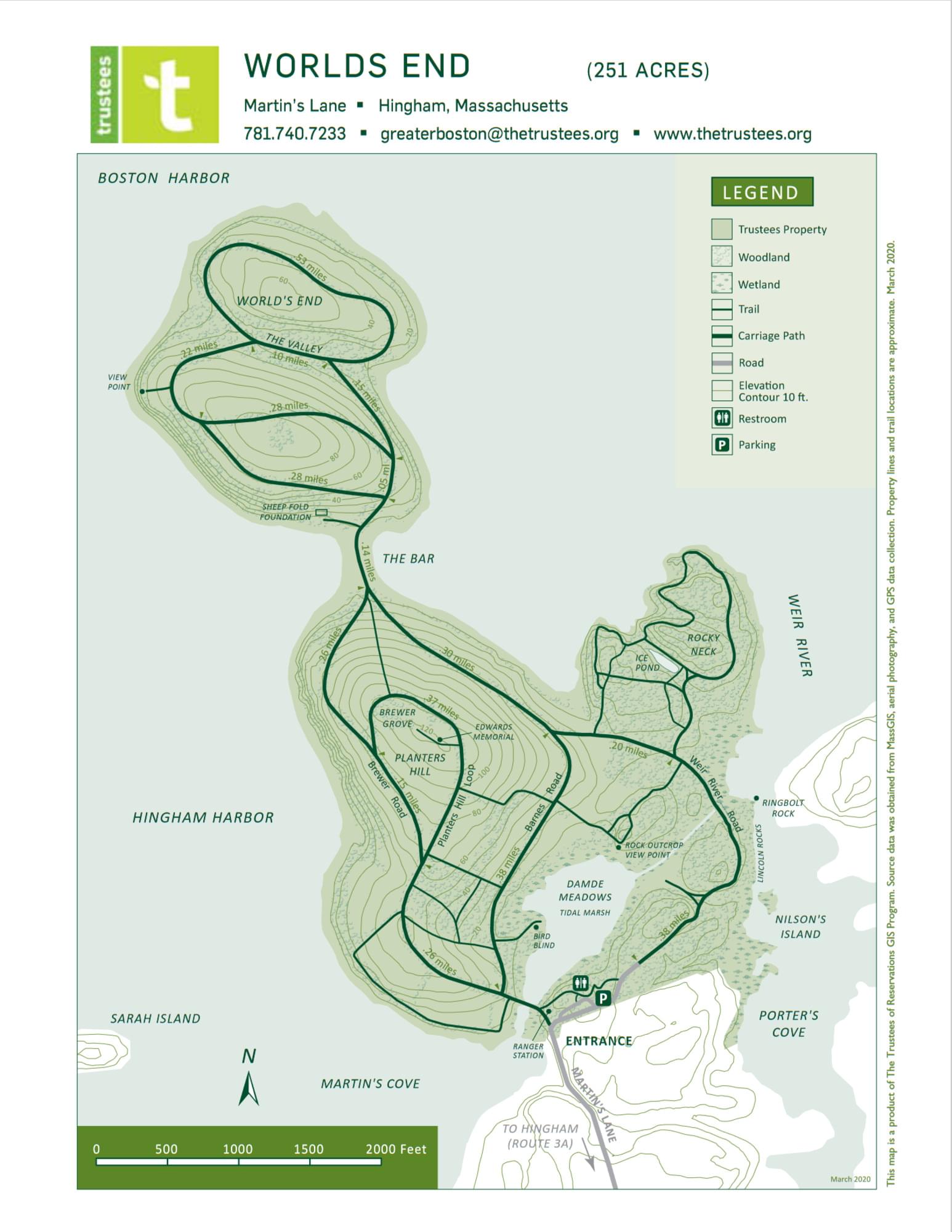
Damde Meadows Tidal Marsh is a coastal wetland located in Worlds End. The marsh provides important ecosystem services, such as water filtration, flood protection, and carbon sequestration. Damde Meadows Tidal Marsh is one of the few remaining salt marshes in the Boston Harbor area, and it is threatened by sea level rise, pollution, and invasive species.
About World's End (TTOR)
See all hotspots at World's End (TTOR)
World’s End comprises four coastal drumlins, spoon-shaped hills formed by glaciers, extending into Hingham Harbor. John Brewer built a mansion here in 1856 and, over the next 30 years, acquired most of the peninsula’s 400-plus acres as well as Sarah and Langley Islands. In 1890, Brewer asked famed landscape architect Frederick Law Olmsted to design a 163-home residential subdivision. The drives were cut, but the development never came to fruition, nor did later proposals for the United Nations Headquarters in the 1940s or a nuclear power plant in the 1960s.
In 1967, thanks to locals’ commitment and tremendous fundraising efforts, The Trustees and dedicated residents from Hingham as well as the surrounding communities were able to preserve this special place.
Throughout your journey, you’ll discover old features transposed to the modern era: just like in its pre-agrarian days, tides nourish former salt marsh through specially built culverts and promote habitat health and diversity, while Olmsted’s designed landscape is preserved through mowing, pruning, cutting, and planting.
Four and a half miles of tree-lined carriage paths and footpaths connect the drumlins, offering dramatic views of the Weir River, Hingham Harbor, and the Boston skyline. Depending on your inclination and the season, walk, jog, or cross-country-ski a rolling landscape encompassing saltwater marshes, meadows, woodlands, and granite ledges covered with red cedars and blueberry thickets.
The landscape plantings and roads of this large peninsula were designed by Frederick Law Olmsted.
The 244-acre peninsula shares many of the features found on the harbor islands. Overlooking Hingham Bay, it is formed by two drumlins and has rocky beaches, ledges, cliffs, patches of salt marsh, and an area of freshwater marsh.
Many of the features noted by 19th-century landscape architect, Frederick Law Olmsted’s plan for the grounds remain, including gravel paths, formal tree plantings, and hedgerows bordering old farm fields. In addition, Worlds End offers trails for nature study, cross-country skiing, and, by permission, horseback riding.
Pre-historic evidence indicates that Worlds End was a seasonal campsite for Native Americans. After European contact, farming continued for over three hundred years. Toward the end of the nineteenth century, there was an attempt by property owner John Brewer to subdivide Worlds End into 163 house lots. The plan was never realized, though the groundwork was laid by the landscape architect, Frederick Law Olmsted. The Trustees of Reservations purchased the northern half of the peninsula in 1967 to preserve and protect it for public enjoyment.
Features
Entrance fee
Restrooms on site
Wheelchair accessible trail
Content from Worlds End website
Last updated February 18, 2024