Sugarite Canyon SP--Little Horse Mesa
Sugarite Canyon SP--Little Horse Mesa
Raton, New Mexico 87740
Sugarite Canyon State Park Trail GuideSugarite Canyon State Park Official Website
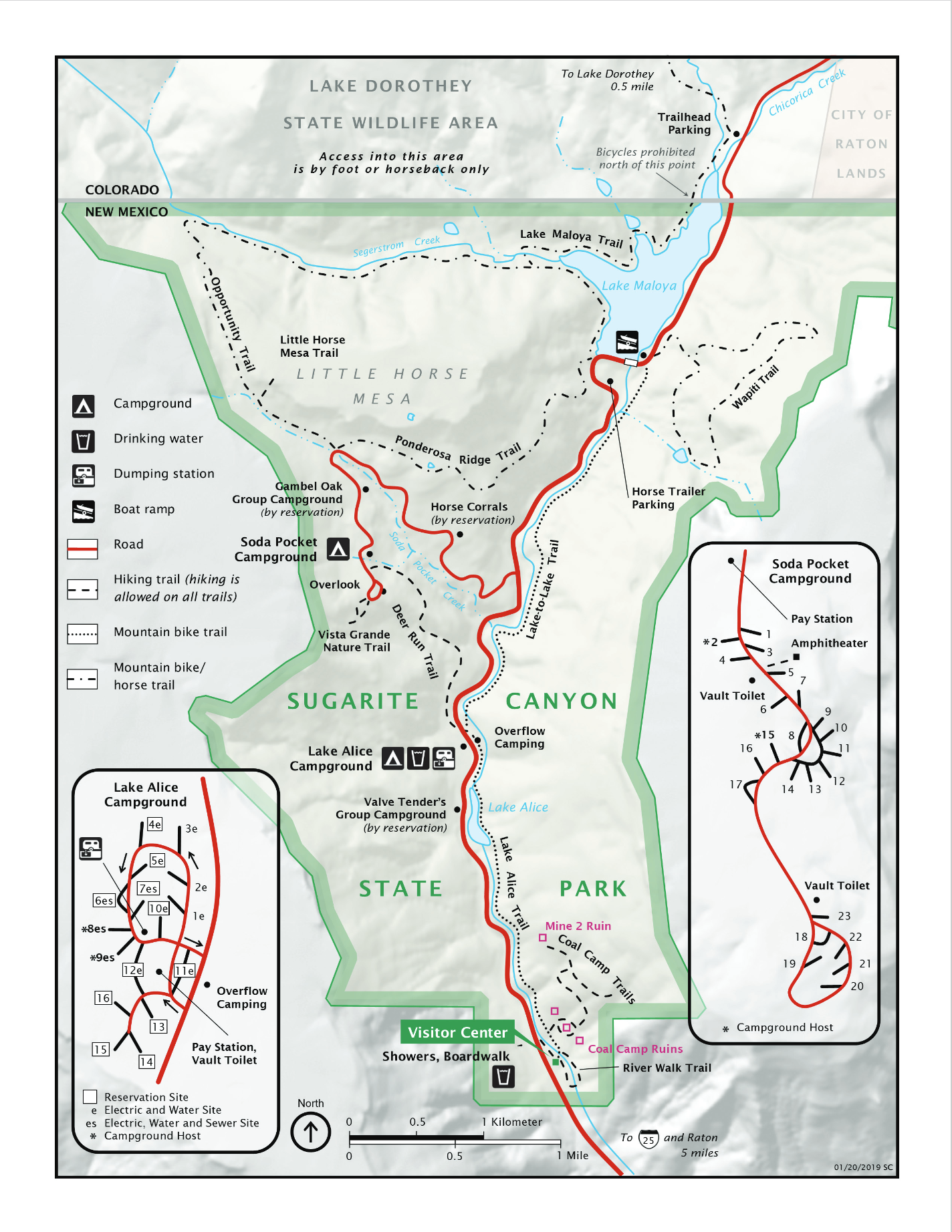
Sugarite Canyon State Park map
About this Location
There are two trails (Opportunity and Ponderosa Ridge), which if hiked together circumnavigate the mesa, and the short Little Horse Mesa trail onto the Mesa.
About Sugarite Canyon State Park
See all hotspots at Sugarite Canyon State Park
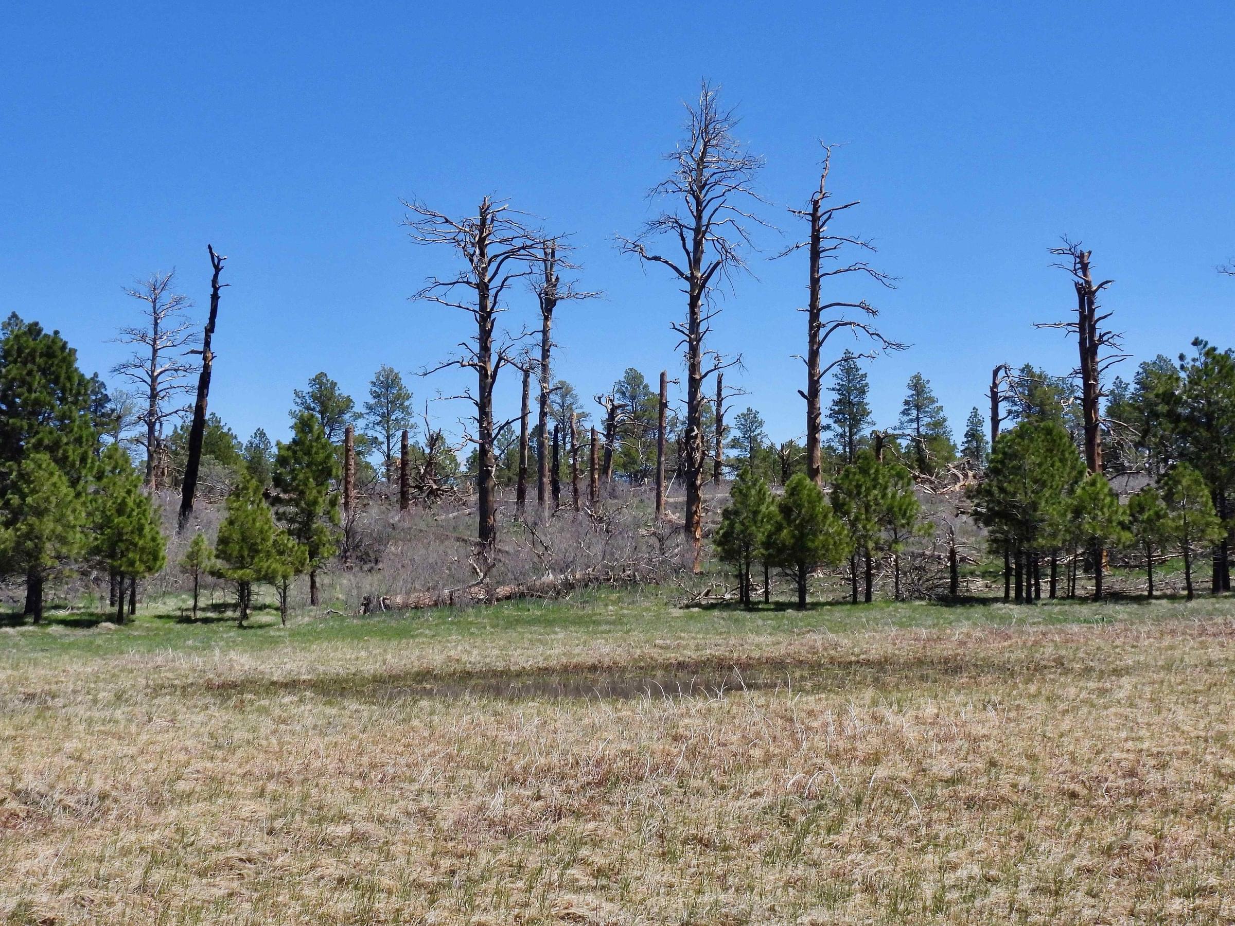
In June 2011, the Track Fire swept through large areas of this park as well as the adjacent Lake Dorothey State Wildlife Area in Colorado. In the years prior to the fire, the City of Raton and the park had conducted extensive thinning of the oak understory and ponderosa woodland in the park to reduce wildfire risk because Lake Maloya is the water supply for the City of Raton. Despite the thinning, the Track Fire was so fast and intense that it burned extensive areas.
Immediately following the fire, restoration was begun under the Natural Resources Conservation Service's Emergency Watershed Protection Program to protect Raton's primary water source.
Since the fire, the habitat has been recovering. Tracking the progress of that recovery and adaptation of birds to the changing ecosystem will make birding particularly interesting in both this park and the adjacent Lake Dorothey.
Sugarite Canyon State Park, 4,000 acres, offers two lakes, 20 miles of hiking trails, two campgrounds, and the remains of a historic coal camp. The park Visitor Center has year-round feeders that attract resident species. The 120-acre Lake Maloya boasts many waterfowl species. In spring and fall, migrating osprey may be seen fishing. In the summer, the park typically hosts events on birds and butterflies.
The nature enthusiast will appreciate the abundance of wildlife, birds, butterflies, and wildflowers among the lakes, creeks, forests, and meadows.
Nearly all outdoor recreation activities are possible: Fishing, boating, hiking, horseback riding, hunting, and camping.
From I-25, take the Raton Exit 452. At the stop sign, turn right (east) on NM-72 for 3.8 miles. Where NM-72 turns sharply east, continue straight on NM-526. The park is about 6 miles from I-25.
Notable Trails
Opportunity Trail
3.7 miles one way, Moderate to Strenuous. Elevation: 7,500' to 8,250'
This trail can be accessed from Soda Pocket or Lake Maloya. From Soda Pocket, a wooded trail of Gambel oak tops out in an aspen grove before descending through an area burned in the 2011 Track Fire. At the bottom of the switchbacks, the trail turns east to follow Segerstrom Valley to Lake Maloya. It can be a 6-mile loop hike if you return via Ponderosa Ridge Trail.
Ponderosa Ridge Trail
1.9 miles one way, Moderate to Strenuous, Elevation: 7,500' to 8,000'
This trail can be accessed from Soda Pocket or Lake Maloya. From Soda Pocket, Ponderosa Ridge Trail descends gradually to Lake Maloya through an area that is regenerating after the 2011 Track Fire. It can be a 6-mile hike if you return via the Opportunity Trail.
Little Horse Mesa Trail
0.12 miles one way, Strenuous, Elevation: 8,000' to 8,320'
To access Little Horse Mesa Trail from Soda Pocket Trailhead, follow Opportunity Trail northwest for about 0.25 miles to the Little Horse Mesa Trailhead. The ascent to the top is steep but very short. You will be rewarded with incredible views of Sugarite Canyon and the plains beyond. Explore the pine-dotted grassy mesa for elk, grouse, and other wildlife.
The Hiking Project website has descriptions and maps of hikes at Sugarite Canyon State Park.
Features
Entrance fee
Restrooms on site
Wheelchair accessible trail
Content from Sugarite Canyon State Park Trail Guide, Sugarite Canyon State Park Official Website, John Montgomery, and Northeast New Mexico Birding and Nature Trail
Last updated November 28, 2023