Kettle Pond State Park
Kettle Pond State Park
6993 State Forest Road Groton, Vermont 05046
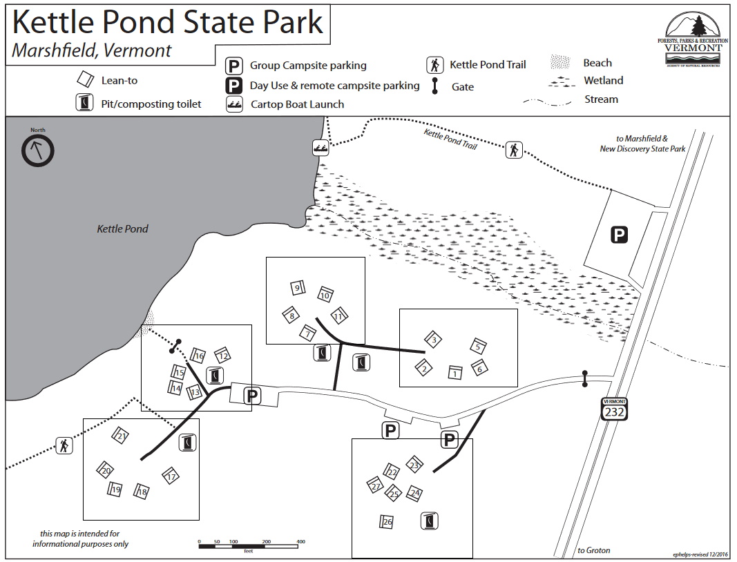
Official WebsiteKettle Pond State Park map
Groton State Forest Official Website
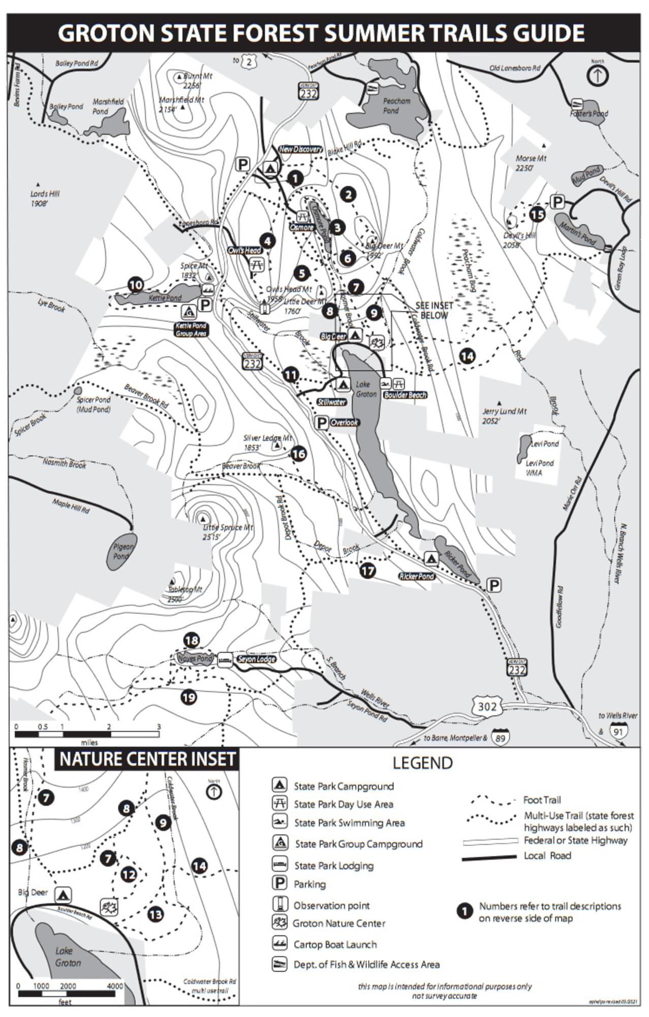
Groton State Forest Summer Trails guide and map
Tips for Birding
Birdwatching in Vermont, p. 107.
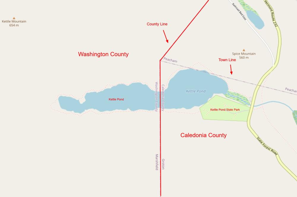
The Caledonia-Washington county line runs north to south through the middle of Kettle Pond. Kettle Pond State Park is located on the east end of the pond and birds reported on checklists are assigned to Caledonia County. The Kettle Pond hotspot is located in Washington County and birds reported on checklists are assigned to Washington County. Birders who carefully keep records of birds seen in each county should be aware of the location of the county line in this area.
About this Location
As early as 1704 Native Americans and the French were using routes through Groton to reach Canada and Massachusetts. Colonists settled this area of Vermont slightly earlier than the rest of the state due to the accessibility the network of waterways provided.
The rocky, tree-covered hillsides were originally covered by white pine, spruce, hemlock, beech, maple, and birch. They were logged by local farmers for lumber, fuel, and potash. The logging industry was large scale for almost 100 years while the railroad was operating. Today, logging is still a vital industry in the area but has lost some of its dominance in favor of modern society’s leisure time movement: private cottages and seasonal homes, park development, and a variety of outdoor recreation activities.
The campground is located on the shores of Kettle Pond, an undeveloped pond. There is no potable water at this site, but you can get water at nearby New Discovery State Park. There is a campers’ beach and miles of hiking and multiple-use trails in Groton State Forest.
Additionally, the Groton Nature Center is nearby and serves all the state parks in the Groton State Forest.
Day use parking for hiking and boating is separate from the campground and is located adjacent to Route 232. The hiking trail and boat portage trail are located in the northwest corner of the parking near the kiosk.
About Groton State Forest
See all hotspots at Groton State Forest
The acquisition of Groton State Forest began in 1919. The Forest is managed for timber resources, wildlife habitat, and recreational activities. Many rare, threatened, and endangered plants and animals occur in the Forest. The most sensitive species are associated with the cliffs, bogs and swamps, lakes, and forests around lakes.
Groton State Forest is home to seven state parks, the Groton Nature Center, and eight lakes and ponds. The area was once home to 12 sawmills and remnants are still visible. The Civilian Conservation Corps (CCC) was instrumental in developing the area, constructing roads, trails, fire lookouts, and picnic shelters, and planting trees within the forest. Glaciers covered the area 10,000 years ago and their retreat created the mountainous terrain mixed with streams, ponds, bogs, and wetlands.
Groton State Forest is also home to several state-designated natural areas, such as Peacham Bog Natural Area (748 acres) and Lords Hill Natural Area (25 acres).
Groton State Forest is open for varied and dispersed recreation, including but not limited to camping, hiking, swimming, boating, fishing, hunting, trapping, horseback riding, cross country skiing, and snowshoeing. The Montpelier and Wells River Railroad bed was converted to a multi-use trail and is part of the Cross Vermont Trail. Snowmobiling is allowed on designated VAST trails.
Notable Trails
The TrailFinder website has a description and map of a hike at Kettle Pond.
Features
Restrooms on site
Entrance fee
Wheelchair accessible trail
Content from Official Website, Groton State Forest Official Website, and Birdwatching in Vermont
Last updated October 11, 2023
 Map adapted from © OpenStreetMap contributors