Wild Branch WMA
Birds of Interest
Ruffed grouse and woodcock can be found on the WMA, as well as a variety of other deciduous and coniferous forest-associated songbirds. Wood duck nesting boxes (in the wetland west of the parking lot) are maintained by the Department and are frequently utilized by wood ducks and hooded mergansers.
About this Location
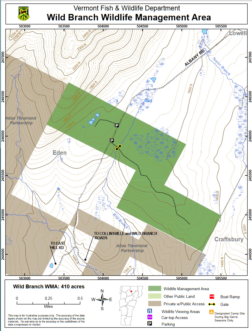
Wild Branch Wildlife Management Area (WMA) is located in the north-central Vermont town of Eden along the Craftsbury town line. The WMA is 410 acres in size and is owned by the State of Vermont and managed by the Vermont Fish and Wildlife Department.
Access to the WMA can be gained from the southeast via VT-14 and the Wild Branch Road in Craftsbury, then onto Collinsville Road to the road that leads to the Eden Mountain Ski Lodge. This road (also known as Albany Road) continues northward bisecting the western portion of the WMA and eventually enters the Village of Albany. The WMA can be accessed from the northeast via VT-14 in Albany Village. The western portion of the WMA can be accessed from a developed parking lot on Albany Road where a large maintained field is located. A second trail accesses the eastern end of the WMA beginning in the southeast corner of the field. This trail is gated.
The WMA lies on the divide between the Wild Branch of the Lamoille River watershed and the Seaver Branch of the Black River watershed. It also lies on the southeastern flank of the Lowell Mountain Range, having an aspect that is generally southeasterly. Elevations range from 2,185 feet in the northwest corner to 1,496 feet in the southeast corner. It is mostly forested with red and sugar maple, yellow and white birch, and beech, as well as areas of softwoods containing hemlock, red spruce, and balsam fir. There are approximately eight acres of field, east, and west of the developed parking lot, maintained by the Department by brush hogging. There are apple trees in the fields that are maintained by release cuttings.
The Wild Branch parallels the Albany Road to the east, and a tributary of the Wild Branch flows through the western portion to the WMA, where a beaver-influenced wetland can be found. Another large (50-acre) wetland exists in the northeast portion of the WMA that is a State-significant natural community classified as a calcareous red maple-tamarack swamp-hemlock swamp. There are two beech stands, one in each extremity of the WMA, that are known to be critical fall feeding areas for black bears.
Features
Roadside viewing
Restrooms on site
Wheelchair accessible trail
Entrance fee
Content from Wild Branch Wildlife Management Area guide and map
Last updated December 3, 2023