Osamequin Bird Sanctuary
Osamequin Bird Sanctuary
Barrington, Rhode Island 02806
Official WebsiteOsamequin Bird Sanctuary Trail Map
About this Location
Osamequin Nature Sanctuary offers visitors a place to enjoy a diverse sample of Rhode Island’s coastal plant and animal communities along the west shore of the Barrington River’s Hundred Acre Cove, Rhode Island’s most extensive and pristine inland estuarine system. This system has been noted by the US Fish and Wildlife Service to be one of the 50 most important coastal marshes between Long Island and Cape Code.
Osamequin is named in honor of the Massasoit or “Great Leader” of the Pokanoket Tribe of the Wampanoag Nation. All of Barrington was part of their homeland of Sowams. Massasoit Ousamequin prevented the failure of the Plymouth Colony and negotiated a peace treaty on March 22, 1621, that lasted over 50 years.
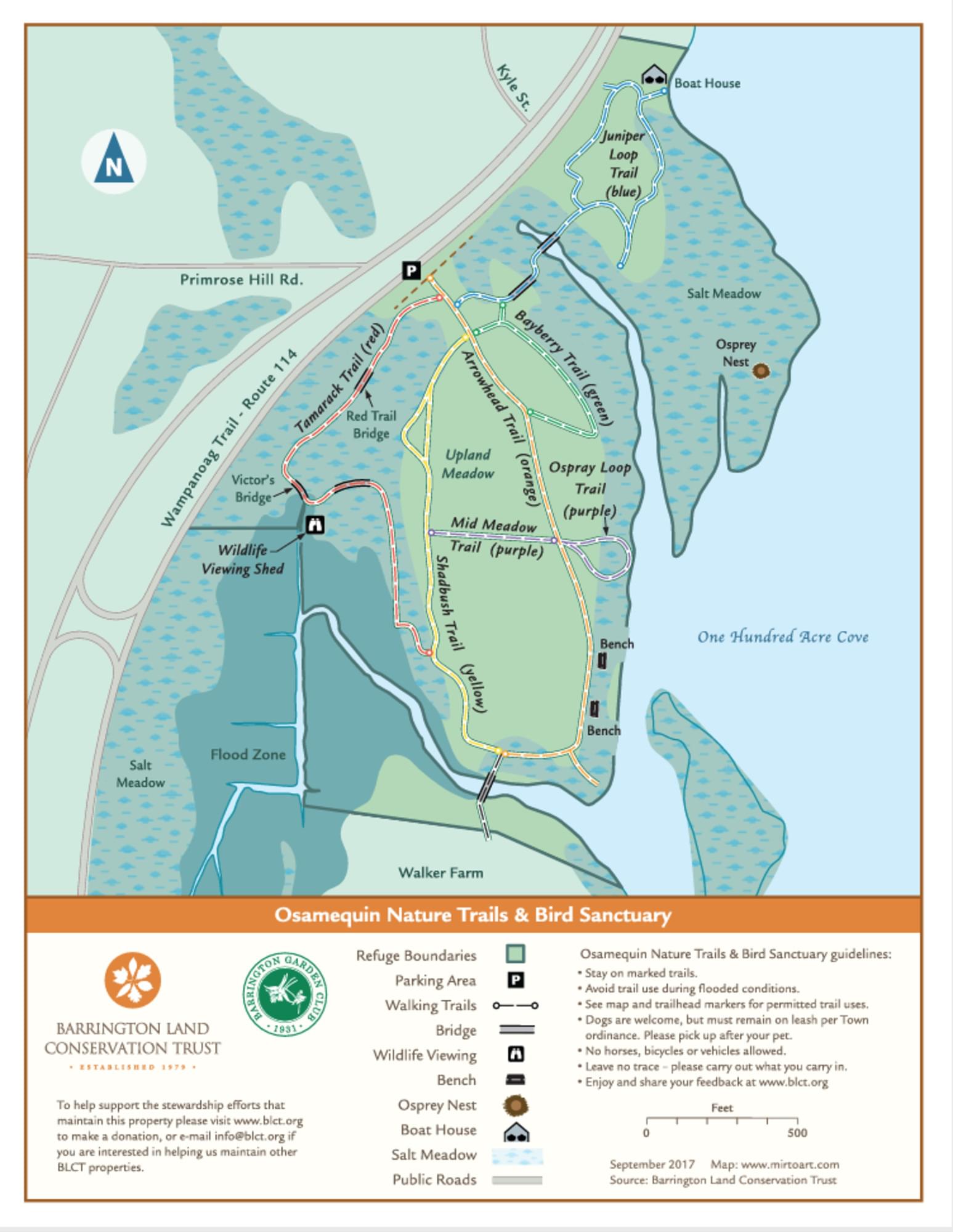
Under the Green Acres program, the Town of Barrington acquired the 42 acres of land that are Osamequin Nature Sanctuary and granted permission to the Barrington Garden Club to develop the area as a conservation area. Dedicated in May 1968, the management and maintenance by the Garden Club has continued ever since in cooperation with the Conservation Commission and the Department of Public Works.
There is something to offer in every season. Salt marsh islands in the cove are visible from the shoreline of the refuge – bring your binoculars for bird-watching. Horseshoe crabs lay eggs on the shoreline each spring. You might see a rare diamondback terrapin sunning upon a log or peeking up from the water. The only known nesting population of this terrapin in Rhode Island is at the Rayner Refuge across Hundred Acre Cove which also offers public hiking trails.
To access the preserve by bus use the Route 60 Newport Providence bus. On the Inbound (northbound) bus, the stop is known as “Wampanoag Trail Opposite Primrose Hill Road.” On the outbound (southbound) “Wampanoag Trail Far Side Primrose.” The preserve is on the inbound side and since Wampanoag Trail is a divided highway it can be a problem getting to the far side stop since there are no crosswalks or crossing lights and the speed limits in the area are 40-45 mph.
Notable Trails
The trail system on the preserve provides many views of the cove as well as the various habitats and environments within the preserve. The trails are all easy and flat and each habitat type is accessible to refuge visitors via the color-coded trails which begin with the green trail at the park entrance. See the trail map for more details on the trail routes and colors. There are two parts to the preserve. What is being described here is the primary “first bird” trail system. The second part, the “second bird” trail system is about .7 mile north on Wampanoag Trail.
Content from Official Website