Kasha-Katuwe Tent Rocks NM
Tips for Birding
The best way to get some of the more hard to find canyon specialists such as Canyon Wren is to hike the main Canyon trail up to the top of the Tent Rocks. This trail offers a spectacular view at the top and provides access to arid pinyon-juniper woodland and rocky canyon habitats. This trail is only 1.5 miles long (3 miles round trip), but can be difficult if you're not a big hiker. If that is the case, there is a Cave Loop trail that is a 1.2 mile loop and is much easier. This trail provides access to the arid pinyon-juniper habitat surrounding the Tent Rocks.
About this Location
*Tent Rocks is closed until further notice*
April 28, 2023 update: Kasha-Katuwe Tent Rocks National Monument remains closed to the public. Pueblo de Cochiti’s main village area remains closed to the public under COVID-19 restrictions, which includes access along NM-22 and Highway 85.
The Bureau of Land Management (BLM) would like to thank the public for their continued patience with us while awaiting updated information regarding the re-opening of the Kasha Katuwe Tent Rocks National Monument (Monument). We have been meeting regularly with the Pueblo de Cochiti to discuss their concerns as well as the concerns of the public, such as resource protection, staffing, and visitation levels.
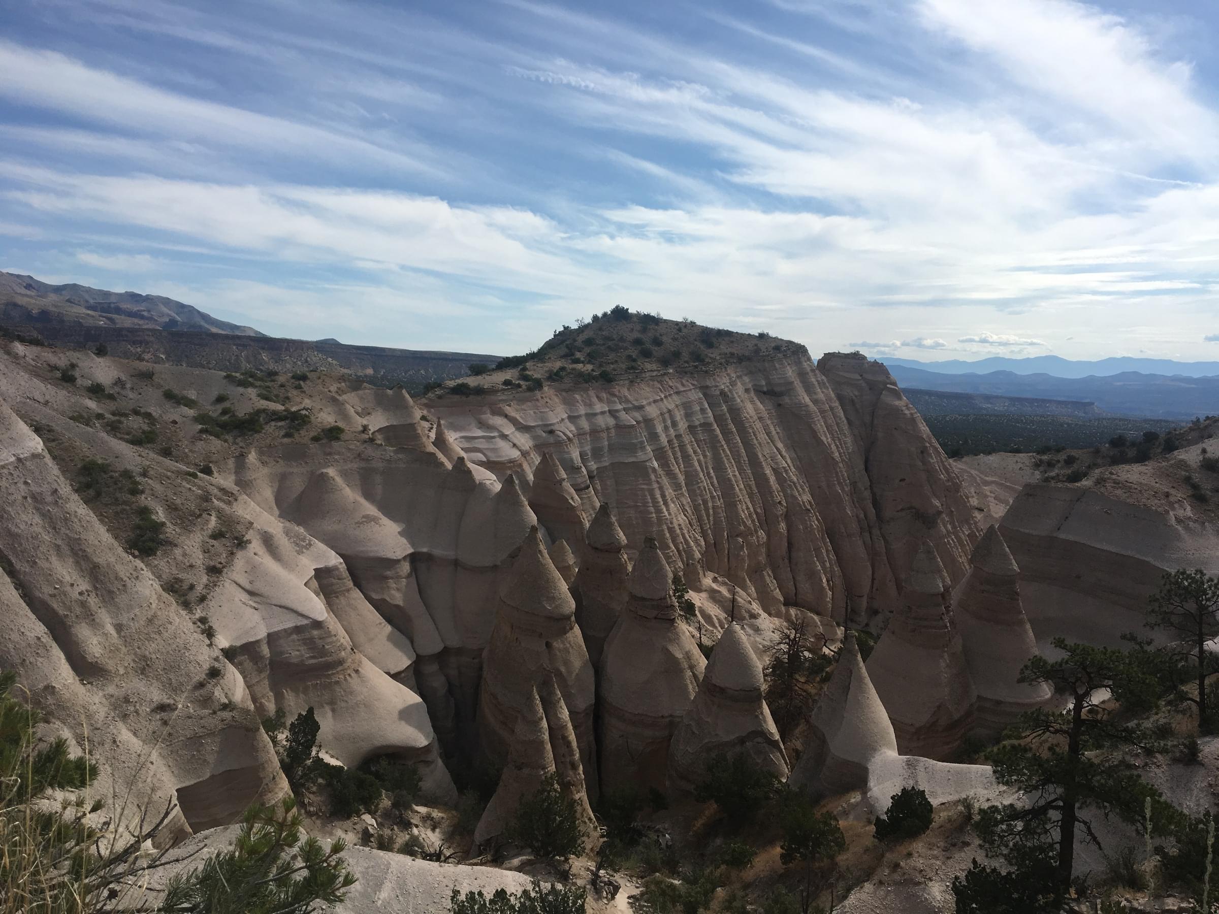
The Kasha-Katuwe Tent Rocks National Monument is a remarkable outdoor laboratory, offering an opportunity to observe, study, and experience the geologic processes that shape natural landscapes. The National Monument, on the Pajarito Plateau in north-central New Mexico, includes a national recreation trail and ranges from 5,570 feet to 6,760 feet above sea level. It is for foot travel only and contains two segments that provide opportunities for hiking, birdwatching, geologic observation, and plant identification.
The cone-shaped tent rock formations are the products of volcanic eruptions that occurred 6 to 7 million years ago and left pumice, ash, and tuff deposits over 1,000 feet thick. Tremendous explosions from the Jemez volcanic field spewed pyroclasts (rock fragments) while searing hot gases blasted down slopes in an incandescent avalanche called a pyroclastic flow.
Precariously perched on many of the tapering hoodoos are boulder caps that protect the softer pumice and tuff below. Some tents have lost their hard, resistant caprocks, and are disintegrating. While fairly uniform in shape, the tent rock formations vary in height from a few feet up to 90 feet.
Please note that dogs are not allowed in the Monument.
Features
Restrooms on site
Wheelchair accessible trail
Entrance fee
Roadside viewing
Content from Official Website and Owen Sinkus
Last updated May 19, 2023