Coronado NM--Cave Trail
Coronado NM--Cave Trail
Official WebsiteCoronado National Memorial Official Website
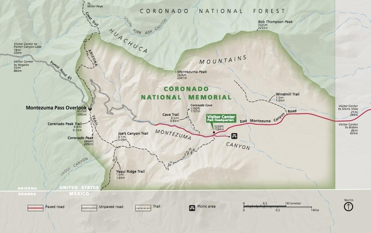
Coronado National Memorial map
Coronado National Memorial Trail Guide
About this Location
Coronado Cave became part of Coronado National Memorial in 1978, when the park expanded its boundaries. The cave may have been used by humans as a shelter and hideout by middle archaic people (up to 8000 years ago) and more recently by the Chiricahua Apache and other Apache peoples, Mexican and European miners, and settlers (however, no archaeological evidence remains in the cave today). The cave is now one of the few open, undeveloped caves in southern Arizona. Coronado Cave is a large cavern 600 feet long and in most places about 70 feet wide.
To get to the Coronado Cave trailhead drive toward the visitor center on East Montezuma Canyon Rd. Approximately .25 mile west of the visitor center on the north side of the road is the parking area for the trail. It is .5 mile to the cave entrance with an elevation gain of 500 feet. Some light scrambling over slick rocks is required to descend to the cave floor. This hike is rated as moderate to moderately strenuous.
About Coronado National Memorial
See all hotspots at Coronado National Memorial
Coronado National Memorial commemorates and interprets the significance of Francisco Vásquez de Coronado’s expedition and the resulting cultural influences of 16th-century Spanish colonial exploration in the Americas. The Memorial preserves and interprets the natural and human history of the area for the benefit and enjoyment of present and future generations.
Coronado National Memorial is the only unit in the National Park System that commemorates the Francisco Vásquez de Coronado Expedition of 1540-1542. When reporting to Congress in 1940 on the establishment of the Memorial, the Committee on Public Lands and Surveys noted that: “Coronado’s expedition was one of the outstanding achievements of a period marked by notable explorations. It made known the vast extent and the nature of the country that lay north of central Mexico, and from the time of Coronado, Spaniards never lost interest in the country. In no small measure, their subsequent occupation of it was due to the curiosity so created.”
The creation of the Memorial was not to protect any tangible artifacts related to the expedition, but rather to provide visitors with an opportunity to reflect upon the impact the Coronado Entrada had in shaping the history, culture, and environment of the southwestern United States and its lasting ties to Mexico and Spain. The Memorial has two sister parks in Mexico.
The location was chosen for the panoramic views of the US-Mexico border and the San Pedro River Valley, the route believed to have been taken by Coronado. It was hoped that this proximity to the border would strengthen bi-national amity and the bonds, both geographical and cultural, which continue to link the two countries.
The Memorial, located near the center of the Sky Island bioregion (the juncture of four major biogeographic provinces: Madrean, Sonoran, Chihuahuan, and Southern Rockies/Mogollon), preserves a rich biological and geological diversity. Visitors are able to enjoy recreational opportunities that foster a better understanding and appreciation of the natural and human history of the area.
Notable Trails
Coronado Cave Trail
1 mile/1.4 km round-trip
Difficulty: Moderate
Elevation change: 500 ft/150 m
The trailhead is located .25 mile/.4 km west of the visitor center.
The entrance to the cave is .5 mile from the trailhead and requires scrambling 25 feet down a rocky slope to the cave floor. The cave interior extends 600 feet in length, with 20-foot high ceilings. Those planning to explore the limestone cave should bring at least two sources of light per person. Please review the regulations at the cave entrance before entering the cave.
Content from Official Website, Coronado National Memorial Trail Guide webpage, and Coronado National Memorial webpage
 Nati
Nati