Cibola NF--Manzano HawkWatch Site
Cibola NF--Manzano HawkWatch Site
Torreon, New Mexico 87061
Official WebsiteManzano Hawkwatch Site brochure and map
Capilla Peak IBA webpage
Cibola National Forest Official Website
Manzano Mountain Wilderness Official Website
Manzo Mountain Wilderness (Wilderness Connect) webpage
Manzo Mountains (SummitPost) webpage
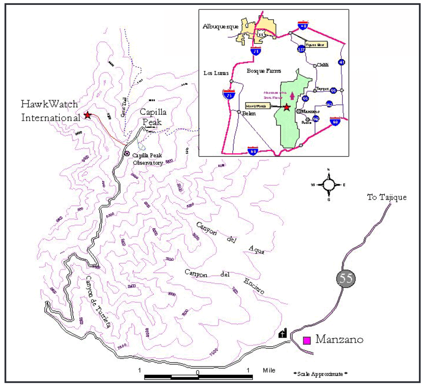
About this Location
Each fall, thousands of migrating raptors fly close to the crest of Capilla Peak in the Manzano Mountains south of Albuquerque. Migrating raptors use updrafts from the rugged, west-facing canyons of the Manzanos to gain lift and conserve energy. Raptors in the west tend to travel in a southeasterly direction during fall migration. In New Mexico, the Jemez and Sangre de Cristo mountain ranges naturally funnel migrating raptors toward the Manzanos.
The Manzano site is designated by Hawk Watch International as a “fall migration site.” Several factors make raptor viewing sites suitable for counts only during one season. Because raptors fly in different directions, depending on spring or fall migration, a site may not have a good line of sight for bird observation. Another factor may be that the funneling effect of the mountain ranges do not work quite the same way in reverse, due to prevailing winds or local topography.
Directions: From Manzano, take the first right onto dirt FR-245, directly across from the church. Stay to the right, following signs for New Canyon and Capilla Peak campgrounds. The road ends in nine miles at the entrance to the second campground below the fire tower. The actual viewing site is one mile from where you park off the road, 200 yards before fire tower road. The trail is marked with a hawk silhouette.
About three-quarters of the migrating hawks seen here include Sharp-shinned, Cooper’s, and Red-tailed Hawk, and American Kestrel. Other raptors observed here include the Golden and Bald Eagle, Osprey, Northern Harrier, Broad-winged, Swainson’s, and Zone-tailed Hawk, Merlin, Peregrine and Prairie Falcon, and Northern Goshawk, as well as other species.
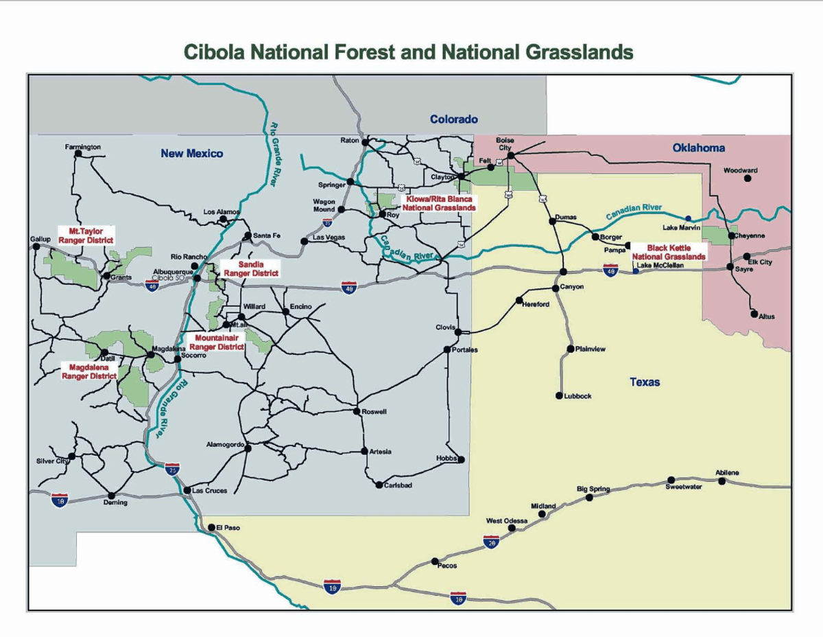
About Cibola National Forest
See all hotspots at Cibola National Forest
Cibola National Forest covers more than 1.6 million acres and includes mountains, grasslands, wilderness, and forests. The name Cibola comes from the Zuni word for their tribal lands, which the Spanish later translated as "buffalo". The forest is home black bears, cougars, elk, and pronghorn. Cibola National Forest offers many recreational opportunities including hiking, camping, fishing, hunting, and skiing. It also has cultural and historical significance, as it contains ancient Native American sites and historic trails.
The National Forest has four ranger districts: Sandia, Mountainair, Magdalena, and Mount Taylor. In addition, the Cibola has four wilderness areas: Sandia Mountain, Manzano Mountain, Withington, and Apache Kid.
About Manzano Mountain Wilderness
See all hotspots at Manzano Mountain Wilderness
The 36,875-acre Manzano Mountain Wilderness Area is located in the Mountainair Ranger District. It was designated as a wilderness area in 1978. The word “Manzano” is Spanish for apple trees, which is what explorers discovered on the eastern edge of the mountains back in the early 1700s. Apple trees are not native to this part of the country, so the mountains were named because of the discovery of these old apple trees.
Spread out across the western slope of the Manzano Mountain Range, this wilderness varies in elevation from about 6,000 feet to 10,098 feet. The terrain is steep and rugged cut with canyons and marked with outcroppings of rock. Thousands of raptors migrate along the Manzanos in spring and fall as they work their way between Canada and Mexico.
Vegetation consists of piñon and juniper at lower heights, gradually taken over by ponderosa pine and then spruce, fir, and aspen higher up. More than 64 miles of a well-developed trail system provide access to the wilderness.
Running for some 40 miles through central New Mexico, east of the Llano de Manzano and west of Estancia Valley, the Manzano Mountains are one of four seemingly connected north-south oriented ranges; from north to south these ranges are the Sandia, the Manzanita, the Manzano, and the Los Pinos Mountains. The southern end of the Manzano Mountains is generally agreed to be Abo Canyon (also known as Abo Arroyo), through which travels US-60. USGS maps show Hell Canyon (Hells Canyon on other maps), on the western slope, as dividing the northern end of the Manzanos from the southern end of the Manzanitas. Hell Canyon is Pueblo of Isleta tribal land, at the northeast corner of Valencia County. Tribal Road 12 extends east into the canyon.
Manzano Peak, at 10,098 FASL the highest point in the range, is part of the 36,875 acre Manzano Wilderness, situated on the range’s western slope. Most of the Manzano Mountains are located within Cibola National Forest, though tribal, state and private land may be found within the range. A relatively small parcel adjoining the wilderness has been designated as a Wilderness Study Area and is administered by the Bureau of Land Management.
Torrance County encompasses almost all of the Manzanos, though some western portions of the range lie within Valencia County (and possibly by some interpretations, a northeast corner of Socorro County), whereas the northernmost portion is in Bernalillo County. As of summer 2023, there are no Manzano Mountains hotspots in Bernalillo or Socorro counties.
Content from Capilla Peak IBA webpage, Cibola National Forest Official Website, Cibola National Forest Wilderness Areas, and John Montgomery