Narrow River--Upper Pond
Narrow River--Upper Pond
Narrow River Official WebsiteNarrow River - New England Boating and Fishing
John H. Chafee National Wildlife Refuge webpage
About this Location
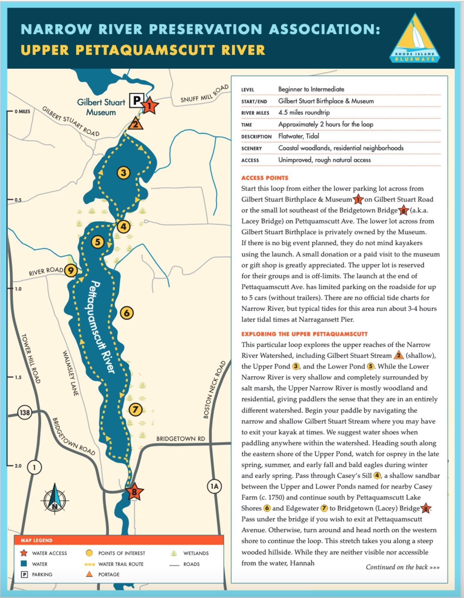
The Upper Pond is north of Casey's Sill, a narrow sandbar between the Upper and Lower Ponds.
A description and map of a kayaking loop, with access points, are found on the Narrow River - RI Blueways webpage.
Upper Pond, the shorter (1/2-mile long) and wider of the two ponds along the upper river, was carved by a glacier some 18,000 years ago. The ponds have surprising depths, up to 45 feet in Upper Pond and 60 feet in Lower Pond‚ given their small size. The water here is stratified, with a top layer of fresh water covering denser salt water below. Deeper still is a layer of anoxic water where no oxygen-breathing creature can survive and where biologists have discovered the presence of a rare phytoplankton.
The Narrow River is subject to a unique, natural phenomenon called an overturn. On the morning of October 10, 2020, Chris Gouveia, a volunteer water monitor with Narrow River's Protective Association’s (NRPA's) River Watch Program, noticed a milky color in the water in the Upper Pond of Narrow River. This is indicative of an overturn, described with pictures by the NRPA.
About Narrow River
See all hotspots at Narrow River
Narrow River, also known as the Pettaquamscutt River, forms a natural boundary between the towns of Narragansett, South Kingstown, and North Kingstown. Not truly a river, it is an approximately seven-mile-long tidal inlet connected by a narrow channel to a series of kettle basins fed by a small stream. Although mostly shallow, it does have two unusually steep-sided ponds, one of which plunges to a maximum depth of approximately 60 feet.
Making up the Narrow River estuary are the two ice block basins, Upper and Lower Ponds, the central narrow channel between Lacey Bridge and Middle Bridge, a southern shallow basin, Pettaquamscutt Cove, and a narrow tidal inlet, The Narrows.
Looking at this shallow trickle of water, you’d never guess that the Narrow River supports one of the largest runs of river herring in the state (although the number of returning fish has declined significantly in the last decade). Each spring, thousands of adult herring and alewives manage to struggle up the fish ladder alongside the mill dam and into Carr Pond, where they spawn on the sand-and-gravel bottom. In the fall, juvenile herring leave the pond and make their way back to the ocean.
Many visitors are able to view the periphery of the John H. Chafee National Wildlife Refuge at Pettaquamscutt Cove as they canoe or kayak the Narrow River. Although the Refuge can be elusive to many human visitors, it is, however, well-known to the migratory waterfowl that rely on it, including the largest population of black ducks in Rhode Island.
Content from Narrow River Official Website, Narrow River - New England Boating and Fishing, and John H. Chafee National Wildlife Refuge webpage