Silver Comet Trail--Don Williams Trailhead

Silver Comet Trail--Don Williams Trailhead
Rockmart, Georgia 30153 GPS 33.99713924758403, -85.15496490992392
Official WebsiteSilver Comet Trail Official Website
Silver Comet Trail (PATH Foundation) website
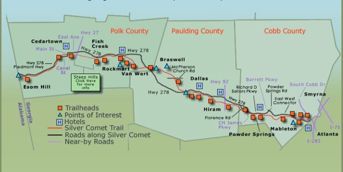
Map
Tips for Birding
Make sure to check out boardwalk over Fish Spring wetlands area.
About this Location
The Don Williams Trailhead is at mile marker 44.8 on the Silver Comet Trail and has a paved parking lot with a portable toilet. Also accessible from the parking lot is the Fish Creek Disc Golf Course.
This quiet section of the Silver Comet Trail is scenic. Heading east, it winds through several miles of beautiful farmland before it leaves the original railbed and runs alongside of Hwy-278. Parts of the trail are in direct sunlight and can be hot in the summer. Heading west, the trail travels a few miles to the Grady Rd Trailhead. Even though Camp Comet is less than a mile west of the Don Williams Trailhead.
About Silver Comet Trail
See all hotspots at Silver Comet Trail
The Silver Comet is a paved pedestrian rail-trail located 13 miles northwest of Atlanta, Georgia. It is 61.5 miles long, free of charge, and travels through Cobb, Paulding, and Polk counties. This quiet, non-motorized trail is for walkers, hikers, bicyclists, rollerbladers, horses, dog walkers, and is mostly wheelchair accessible.
The Silver Comet starts at the Mavell Toad Trailhead in Smyrna, Georgia, and it ends at the Georgia/Alabama state line near Cedartown and the Esom Hill Trailhead. At the Georgia/Alabama state line, the Silver Comet Trail connects to the 33-mile long Chief Ladiga Trail. Both the Silver Comet and Chief Ladiga are fully paved rail-trails built on abandoned railroad lines. The combined Silver Comet and Chief Ladiga trail length is estimated to be 94.5 paved miles from Smyrna, Georgia to Anniston, Alabama.
Features
Restrooms on site
Wheelchair accessible trail
Roadside viewing
Entrance fee
Content from Official Website, Silver Comet Trail Official Website, and Silver Comet Trail (PATH Foundation) website
Last updated March 29, 2024