BHI--World's End (TTOR), Hingham
BHI--World's End (TTOR), Hingham
The Trustees of Reservations Hingham, Massachusetts 02043
Boston Harbor Islands Official WebsiteBoston Harbor Islands (National Park Service) webpage
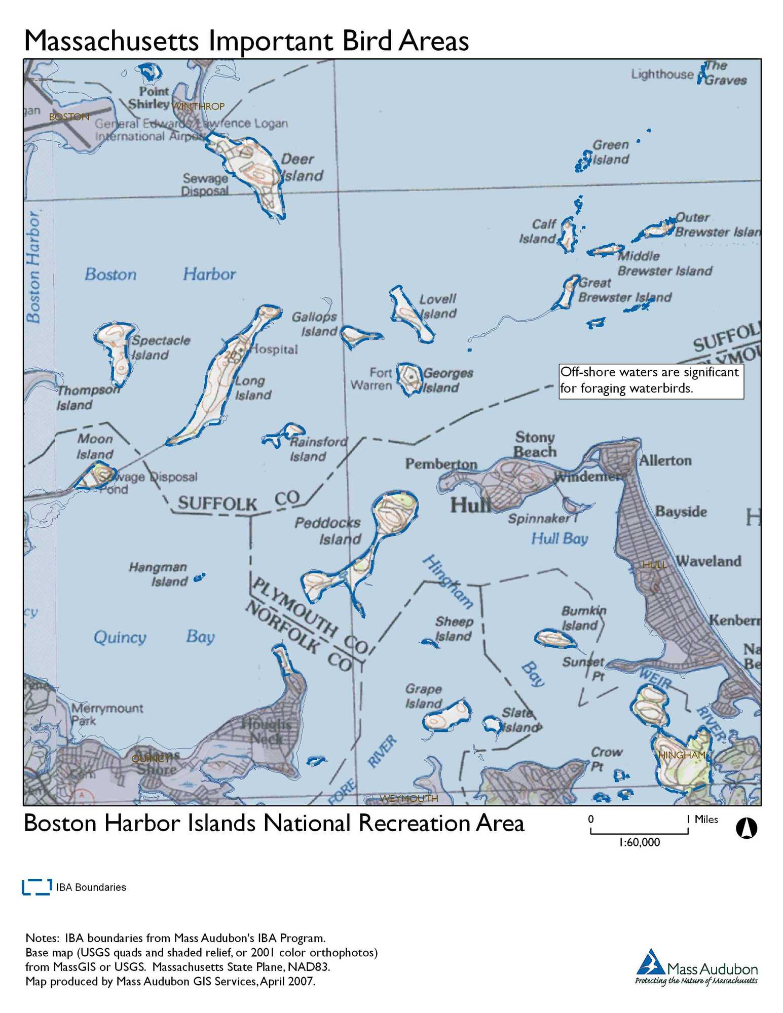
Boston Harbor Islands map
Boston Harbor Islands National Recreation Area IBA
Worlds End website
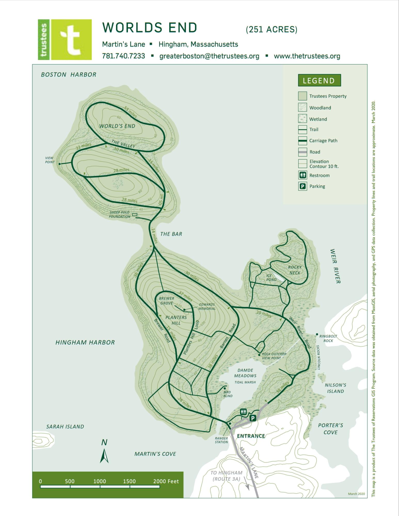
Worlds End map
Tips for Birding
When submitting eBird observations at Worlds End, it is most helpful to start a new checklist for each hotspot in the park. Use the general hotspot when you have a checklist that includes multiple locations or if no other hotspot or personal location is appropriate for your sightings.
About Boston Harbor Islands
See all hotspots at Boston Harbor Islands
Located just minutes from downtown Boston, the Boston Harbor Islands include 34 islands and peninsulas spread over 50 square miles. Working with city, state, federal, and nonprofit partners, the park is a place where you can walk a Civil War-era fort, visit historic lighthouses, explore tide pools, hike lush trails, camp under the stars, or relax while fishing, picnicking, or swimming, all within reach of downtown Boston.
Between the horn of Cape Ann to the north and the defiant, jutting arm of Cape Cod to the south and east, the Boston Harbor forms a giant crescent on the central coast of Massachusetts and is the beating heart of the New England shoreline. The harbor sits within an ancient feature, known as the Boston Basin, which predates the formation of North America. Over the course of over 400 million years, it has seen tropical latitudes, multiple advances and recessions of the sea, and multiple periods of glaciation—the latter couple of which deposited and then carved many of the hills that currently dapple its surface. Today, within a vibrant metropolitan area, the Boston Harbor Islands provide a dynamic assembly of ecosystems, ranging from rocky, windswept shores to dense forests to developed and filled land—all with a long and complicated history of human use.
The hub islands, Georges and Spectacle, offer a world-class experience complete with hiking trails, picnic areas, interpretative walks, recreational programs, concessions, and state-of-the-art visitor centers. The more rustic islands, Peddocks, Bumpkin, Grape, and Lovells, provide camping adventures that offer a unique experience for locals and visitors to the Boston area. Thompson Island is open to the public via public ferries on specified weekends throughout the summer and fall.
Allow at least a half day to see one island and a day to see more. Georges, Spectacle, and Peddocks Island have fresh water and restrooms, while Lovells, Bumpkin, and Grape Island have composting toilets. There are no trash receptacles; please pack out what you pack in.
A visit to the Boston Harbor Islands is an opportunity to play, learn, serve, and work within the largest recreational open space in the Boston area.
The Boston Harbor Islands National Recreation Area comprises 34 islands ranging in size from less than 1 acre to 274 acres. A variety of habitats, including marine, rock cliffs, beaches, salt marshes, and forests support many different species in all seasons. Several species of special concern in Massachusetts have been observed on the Islands including Common and Least Tern, Barn Owl, and Common Loon. The Northern Harrier, a threatened species, also occurs on the islands. Significant numbers of colonial-nesting waterbirds, including Double-crested Cormorants, Black-crowned Night-Herons, and Snowy Egrets have been present for at least two decades. Migratory shorebirds, raptors, and songbirds utilize the harbor islands during the spring and fall, and great flocks of waterfowl overwinter there.
About World's End (TTOR)
See all hotspots at World's End (TTOR)
World’s End comprises four coastal drumlins, spoon-shaped hills formed by glaciers, extending into Hingham Harbor. John Brewer built a mansion here in 1856 and, over the next 30 years, acquired most of the peninsula’s 400-plus acres as well as Sarah and Langley Islands. In 1890, Brewer asked famed landscape architect Frederick Law Olmsted to design a 163-home residential subdivision. The drives were cut, but the development never came to fruition, nor did later proposals for the United Nations Headquarters in the 1940s or a nuclear power plant in the 1960s.
In 1967, thanks to locals’ commitment and tremendous fundraising efforts, The Trustees and dedicated residents from Hingham as well as the surrounding communities were able to preserve this special place.
Throughout your journey, you’ll discover old features transposed to the modern era: just like in its pre-agrarian days, tides nourish former salt marsh through specially built culverts and promote habitat health and diversity, while Olmsted’s designed landscape is preserved through mowing, pruning, cutting, and planting.
Four and a half miles of tree-lined carriage paths and footpaths connect the drumlins, offering dramatic views of the Weir River, Hingham Harbor, and the Boston skyline. Depending on your inclination and the season, walk, jog, or cross-country-ski a rolling landscape encompassing saltwater marshes, meadows, woodlands, and granite ledges covered with red cedars and blueberry thickets.
The landscape plantings and roads of this large peninsula were designed by Frederick Law Olmsted.
The 244-acre peninsula shares many of the features found on the harbor islands. Overlooking Hingham Bay, it is formed by two drumlins and has rocky beaches, ledges, cliffs, patches of salt marsh, and an area of freshwater marsh.
Many of the features noted by 19th-century landscape architect, Frederick Law Olmsted’s plan for the grounds remain, including gravel paths, formal tree plantings, and hedgerows bordering old farm fields. In addition, Worlds End offers trails for nature study, cross-country skiing, and, by permission, horseback riding.
Pre-historic evidence indicates that Worlds End was a seasonal campsite for Native Americans. After European contact, farming continued for over three hundred years. Toward the end of the nineteenth century, there was an attempt by property owner John Brewer to subdivide Worlds End into 163 house lots. The plan was never realized, though the groundwork was laid by the landscape architect, Frederick Law Olmsted. The Trustees of Reservations purchased the northern half of the peninsula in 1967 to preserve and protect it for public enjoyment.
Features
Restrooms on site
Wheelchair accessible trail
Entrance fee
Content from Boston Harbor Islands (National Park Service) webpage, Boston Harbor Islands National Recreation Area IBA, and Worlds End website
Last updated February 18, 2024