Otter Slough CA
Tips for Birding
Birding tactics for the area will vary during the year. A detailed map is highly recommended (see below). In waterfowl hunting season, the numbered hunting units and refuges are not accessible for birding; however, much of the area can still be birded from county roads and adjacent gravel parking lots. Otter Slough is in the Duck Hunting Middle Zone, with a season typically including early November through the first week of February. Exact dates are available at the MDC website. Pay close attention to signage on the area to help keep you honest.
The conservation area is divided by berms into a large number of pools or fields where water levels are manipulated by pumping and draining in order to further various management goals. Because the water levels vary great ly with seasons, and year to year, it is not easy to specify in advance which pools will be good for passerines, which for shorebirds, which for waders, and which for waterfowl. The best tactic is to visit and check numerous areas; with a little patience this will lead you to a variety of habitats. We describe below a typical driving route to the best birding habitat.
As you drive in on CR 675, the parking lot for Pool 10 is on the right at the east boundary of the area. Stop here for passerines and a w etland pool to the north. CR 675 then turns south, and there is a parking area at this corner. Walk north along a service road from here to Miller Woods, which is good for woodland birds. The road passes by an open marsh area about ¼ mile in, where ducks and waders may often be found. Across 675 from the parking lot is a small patch of woods often good for passerines.
Next, drive west on Conservation Lane past marshy Plover Pond to Cypress Lake, about 100 acres of open water, which is the best place in the area for diving ducks, especially Ruddy Ducks and Ring- necked Ducks. It is also a good spot for Bald Eagles year round, and Osprey and Peregrine Falcons in spring and fall. The lake also attracts gulls and terns. The road turns left at the west end of the lake; to the right is the area headquarters, with bordering woods and a small deck overlooking the cypress/tupelo swamp of Otter Lake. To the left is a parking area at the head of the boardwalk trail.
This trail is the best location for spring and fall migrant warblers and vireos, and Prothonotary Warblers in summer. In winter, the boardwalk will have Winter Wrens, Brown Creepers, and Warblers in summer. In winter, the boardwalk will have Winter Wrens, Brown Creepers, and kinglets. Orange--crowned Warblers are also a possibility here in winter.
Conservation Lane continues around the west end of Cypress Lake and curves to the east past Pool 13, a large area of shallow marshland that is often good habitat for waders, shorebirds, and dabbling ducks. It then intersects with CR 675 again. Turning right on CR 675, you reach a small campground area. A small, weedy ditch along the edge of this area has held Sedge Wren and Marsh Wren at times. Just south on 675, turn into Millet Mile for a good view of Pool 15 and Frog Pond on the right. In the brushy area on the left side of the road, listen for Bell s Vireo in summer and Fox Sparrow in winter. At this point, a gate usually blocks Millet Mile, so go back to 675. Continuing south on CR 675 you pass Pools 16 and 17. Each has a parking lot you can pull into to view the pool. While there, be on the lookout for White crowned and Savannah Sparrows in winter. Also, watch the overhead lines on 675 for Loggerhead Shrike and American Kestrel. CR 675 intersects with CR 670 at the southern border of the CA, where you turn west.
Private farm fields on the south side of CR 670 and east of 675 often yield Horned Larks, Killdeer, and other open land species; American Pipit is a possibility. The pools on the north side may have waterfowl, waders, and shorebirds. Be sure to stop at the R8/R9 par king lot to view the pools and check the nearby brushy areas for passerines. Cross Dead End Ditch and stop for a good view of Pool 21. This road continues to the west boundary, where you turn north on CR 691. A cul de sac curves off to the west into some old field succession land, often good for winter sparrows and Eastern Towhee year round, and a view of the St. Francis River. Except when closed for waterfowl season, 870 Express goes northeast back to Cypress Lake, past Pools 23 27. Expect migrant shorebirds and all the typical dabbling ducks in these pools, plus a decent chance for Canvasback, Bufflehead, and Ring-necked Duck.
Continuing straight north on CR 691 takes you onto private land for a mile; turn east on CR 679, crossing Cypress Ditch, a nd follow it ½ mile east, then north a short distance to the turnoff for Pools 29 30. There is a parking area between the two pools. These pools, with some shrubby vegetation, are often home to large numbers of ducks and waders; Sora, Marsh Wrens, and Se dge Wrens can also be here.
To continue driving, go back out to CR 679 and follow it north. It turns east at the north end of Pool 31 , and a stop here can be worthwhile. Walk up on the berm to look north into Pool 34. A short distance east is the p arking lot for Pools 31 and 32. Then CR 679 continues and turns north again. A parking area at the corner gives access to Pool 33 here. From here, it s another ½ mile north to the Pintail Path turnoff on the west side; drive ½ mile west to a parking lot from which you can view Pool 34, as well as some wooded areas to the west and north.
Leaving Pintail Path, you turn north on CR 679 and exit the CA. In 1 ½ miles it intersects with CR 642; turn right (east) a bit over 1 mile to a Highway TT and a bridge where the road crosses ditch 12. The south side of the road is in the Conservation Area here, and shrubs and trees along the ditch may offer species you wouldn t see elsewhere. From here, take TT north to highway 60 or continue east about a mile to rejoin highway ZZ, which will also take you north to 60.
Depending on your pace of birding, the route outlined here could take most of a day. To maximize your Otter Slough experience for a short duration trip, view Cypress Lake and Otter Lake, walk the boardwalk trail, and drive Conservation Lane.
Birds of Interest
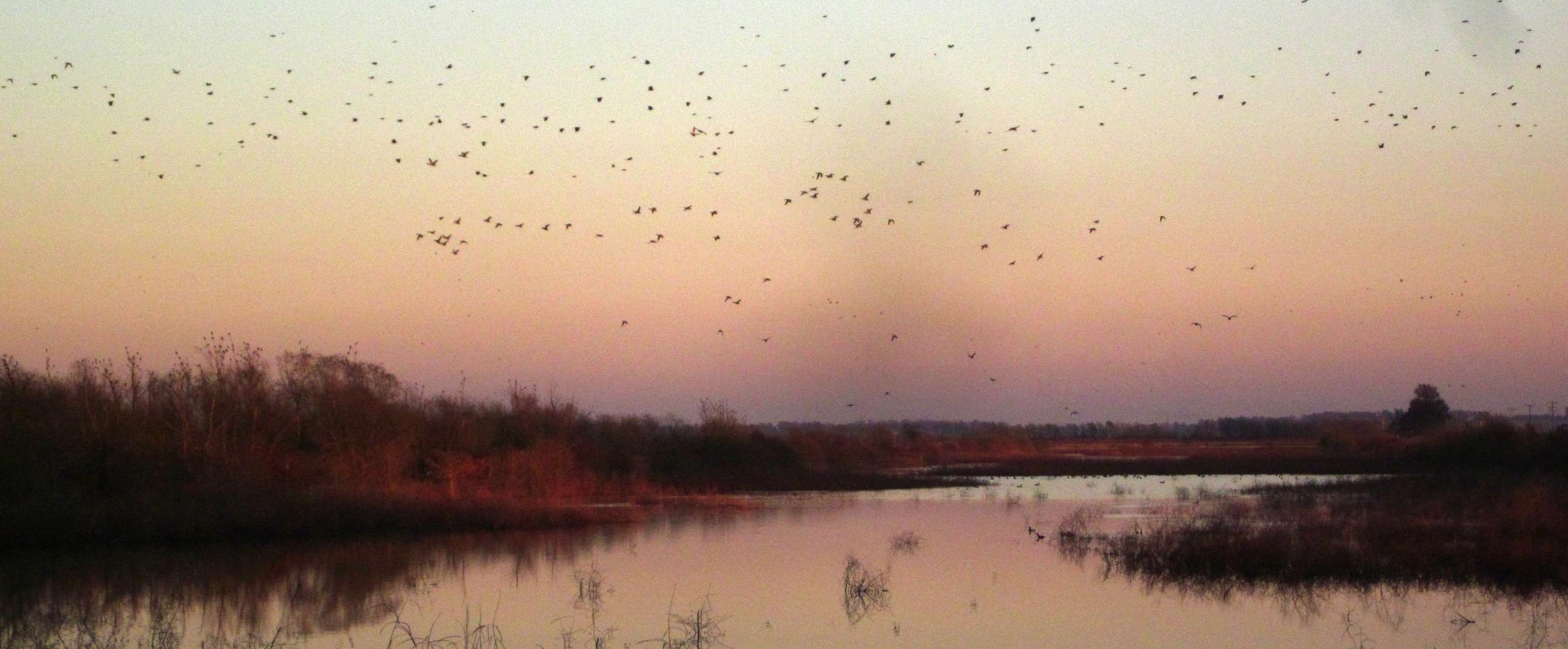
This large and diverse area is worth visiting any time of year. Although it is managed primarily for wate rfowl, 275 total species have been reported in eBird. Ducks and geese abound in the winter and during migration; 30 species of shorebirds and numerous waders, including nesting Black necked Stilts, have been reported; and diverse passerines including 34 species of warblers can be found.
About this Location
From Dexter, MO, take Highway 60 west, then Route ZZ south 8.5 miles. Take County Road 675 west ¾ mile to the area entrance.
This conservation area preserves a rare remnant of the cypress/tupelo swamp habitat once found throughout the Bootheel of Missouri. Much of the area is farmland that has been converted to wetland habitat. The area is managed actively for waterfowl, so in season it shelters tens of thousands of ducks and hundreds of thousands of geese. Approximately 25 miles of road are accessible for birding in the conservation area.
Notable Trails
The boardwalk trail is described above in Tips for Birders.
Features
Restrooms on site
Roadside viewing
Wheelchair accessible trail
Entrance fee
Last updated May 23, 2023
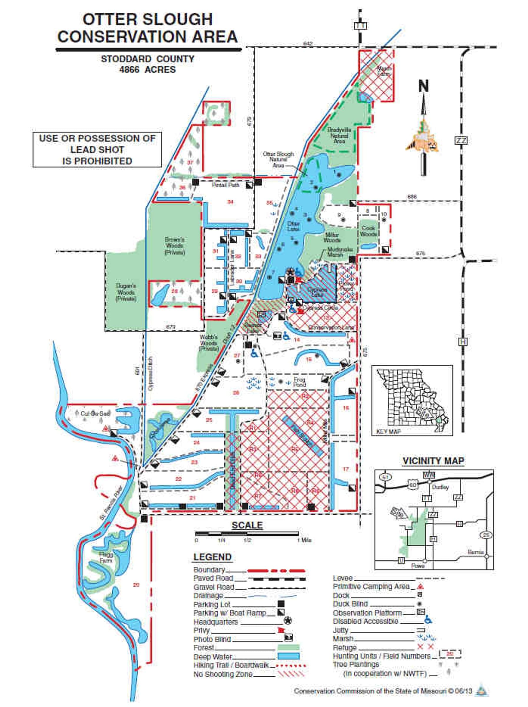 Otter Slough map
Missouri Department of Conservation