Maxwell NWR--Road A-2 Woodlot

Maxwell NWR--Road A-2 Woodlot
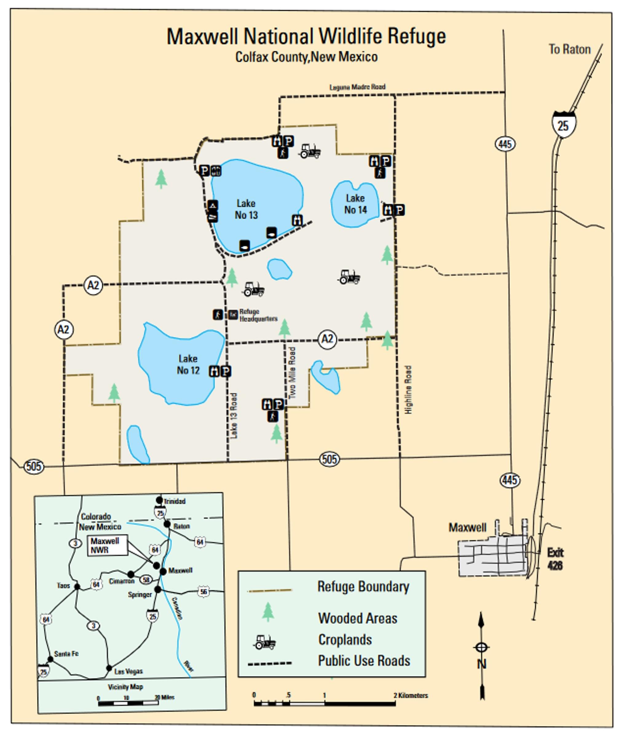
County Road A-2 Maxwell, New Mexico 87728
Maxwell National Wildlife Refuge Official WebsiteMaxwell National Wildlife Refuge map
Birds of Interest
In summer, the Road A-2 Woodlot is a reliable location for Eastern Kingbirds, as well as Western and Cassin’s kingbirds. Northern Harrier has been reported in multiple lists for this hotspot during late summer and early fall, whereas Broad-tailed Hummingbird has been reported in mid-spring and the latter part of summer.
About this Location
Although not covering the extent of other hotspots on Maxwell National Wildlife Refuge, maybe being the same size as the Headquarters compound, the Road A-2 Woodlot can be a very productive site, particularly if there is water in the ditch. This is roadside birding, but doesn't need to be done in a vehicle; you can walk the road. The hotspot map pin is located where County Road A-2, here running east-west, crosses Lake 13’s east outflow ditch, through which water flows northwest to southeast if released from the lake. A-2 is fenced on both sides, land to the southeast of the ditch crossing being private ranch property and land to the north and southwest having Refuge “Entry Beyond this Point Prohibited” signage. The woods, mostly elm, but including some cottonwood, form a narrow swath around the ditch; elm also line the north fenceline for about a hundred yards along the road east of the ditch crossing. There may be water present in a distant, shallow, off-refuge playa to the southwest when there is no water in the ditch, and vice-versa.
Water managed by the Vermejo Conservancy District is diverted from the Vermejo River and Chico Rico Creek, traveling via a series of canals to refuge lakes. Thus, water flows into Lake 13 from the northwest, through a canal west of the North Lake 13 Viewing Area. Water flows out of the lake to the south, immediately bifurcating to the West 13 Ditch and East 13 Ditch, the latter creating the woodlot. Because the average evaporation rate of the lakes is more than twice that of precipitation, they are typically dry in years where irrigation water is not released to the Refuge by the District; the number of lakes with water and their depth similarly depends on the amount of water released to the Refuge.
About Maxwell National Wildlife Refuge
See all hotspots at Maxwell National Wildlife Refuge
The Maxwell National Wildlife Refuge presents visitors with a unique wildlife viewing experience. Visitors are treated to year-round views of hawks, owls, eagles, wild turkeys, white-tailed deer, mule deer, and black-tailed prairie dogs.
Located in northeastern New Mexico at an elevation of 6050 feet, Maxwell National Wildlife Refuge encompasses 3,699 acres of short-grass prairie, playa lakes, woodlots, wetlands, and crop fields. The refuge sits in an open basin surrounded by high mesas to the northeast and the Sangre de Cristo Mountains to the west. Since 1965 this landscape has been managed for the benefit of wildlife and has provided a feeding and resting habitat for migratory birds.
Birders and wildlife watchers can challenge themselves by attempting to check off all 289 species of birds found on the refuge. American kestrels, wild turkeys, and Wilson’s phalaropes are a few of the common species you will enjoy seeing at Maxwell National Wildlife Refuge.
Mid-October on the refuge is generally the peak fall migration of sandhill cranes, geese, and ducks. However, any time of year you are likely to see a diversity of wildlife. Wildlife watching is generally best during the morning and at dusk when wildlife is most active.
Rangeland on the refuge is rolling prairie and reclaimed farmland containing a variety of grasses including blue grama, galleta, sand dropseed, threeawn, and buffalo grass, as well as fourwing saltbush and cactus. Lakes on the refuge provide 700 acres of waterfowl roosting and feeding habitat. Wet years bring dense shoreline vegetation, while the lakes may disappear in dry years.
The refuge lakes and associated Stubblefield Lake are primarily for water storage for irrigation purposes for surrounding ranches and are managed by the local water manager. The refuge owns the surrounding grassland but not the water making water management impossible. Stubblefield Lake is privately owned. Fishing is allowed in some areas of the refuge.
From Raton, take I-25 south to Maxwell, go north on NM-445 for 0.8 miles, and west on NM-505 for approximately 2.5 miles. Turn north at the entrance sign (1.5 miles to headquarters).
The vault toilets by the parking area for Lake 13 are seasonally open and maintained. There are flush toilets in the Visitor Center (headquarters building), but that building is open on an extremely limited basis.
Features
Roadside viewing
Restrooms on site
Wheelchair accessible trail
Entrance fee
Content from Maxwell National Wildlife Refuge Official Website and John Montgomery
Last updated September 21, 2023