Constitution Hill (BNRC)
Constitution Hill (BNRC)
Berkshire Natural Resources Council Bridge Street Lanesborough, Massachusetts 01237
Official WebsiteConstitution Hill map
About this Location
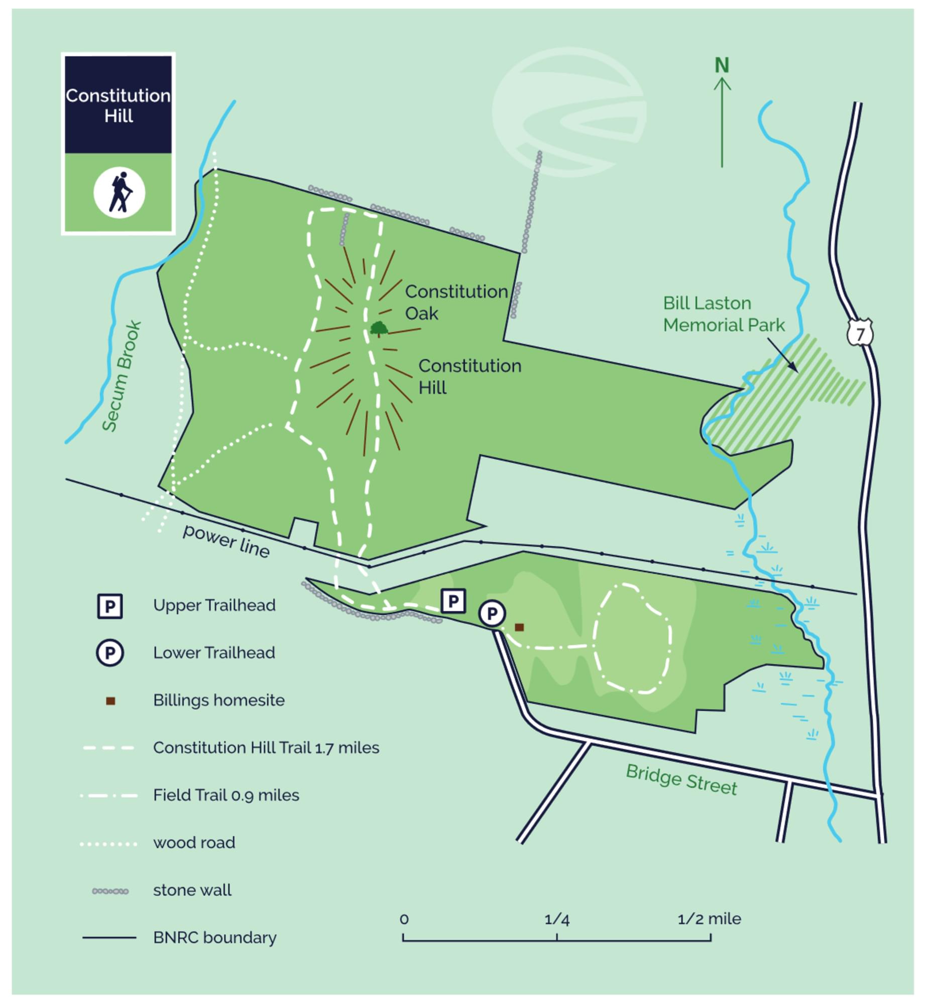
A Lanesboro delegate to the convention in Boston weighing state ratification of the proposed new US Constitution arranged for a bonfire to be lit atop the hill if Massachusetts approved it. The state did, and the signal could be seen for miles. The moderate 60-90 minute Constitution Hill Trail lets hikers recall that historic moment. The Field Trail offers an easy walk and views of Mount Greylock.
This land, and all of the present-day Berkshires, are the ancestral homeland of the Mohican people, who were forcefully displaced to Wisconsin by European colonization. These lands continue to be of great significance to the Stockbridge-Munsee Mohican Nation today.
In 1788, a Lanesboro farmer named Jonathan Smith was chosen to represent his town at the convention in Boston that would decide whether Massachusetts should ratify the proposed new US Constitution. At the convention, he made a persuasive argument in favor of it as a way to prevent outbreaks of violence like Shays’ Rebellion in Western Massachusetts. The bonfire he had organized atop “Bald Headed Hill” alerted residents of Lanesboro and surrounding towns that his view had prevailed and Massachusetts had ratified the Constitution.
The hill is no longer bald and was renamed “Constitution Hill” by Smith. The forest has long since reclaimed the landscape, though there are winter views from the ridge after leaves have fallen. A plaque marks the bonfire site, near an oak that was planted in 1921 to replace an oak that was the solitary sentinel on the hill in Smith’s day.
Near the trailhead and its two parking areas are a reclaimed orchard and the site of the home of a 19th-century humorist, Josh Billings. He is now memorialized by Berkshire County’s annual Josh Billings RunAground triathlon.
Notable Trails
The Constitution Hill Trail, 1.7 miles, takes visitors past the Constitution Oak tree and a large rock outcrop. Beyond the summit, the trail turns westward past an old stonewall before bringing hikers back on what eventually becomes a woods road whose surface was once hardened by chunks of slag glass, which are still visible. Slag glass is a byproduct of iron production that was used as fill on old roads.
The Field Trail, 0.9 miles, is a mowed path that parallels Bridge Street before veering downhill through the hedgerow and winding around the field. This trail has great views of Mount Greylock.
Features
Restrooms on site
Wheelchair accessible trail
Entrance fee
Content from Official Website
Last updated November 23, 2023