Clam River (BNRC)
Clam River (BNRC)
Berkshire Natural Resources Council Sandisfield Road Sandisfield, Massachusetts 01255
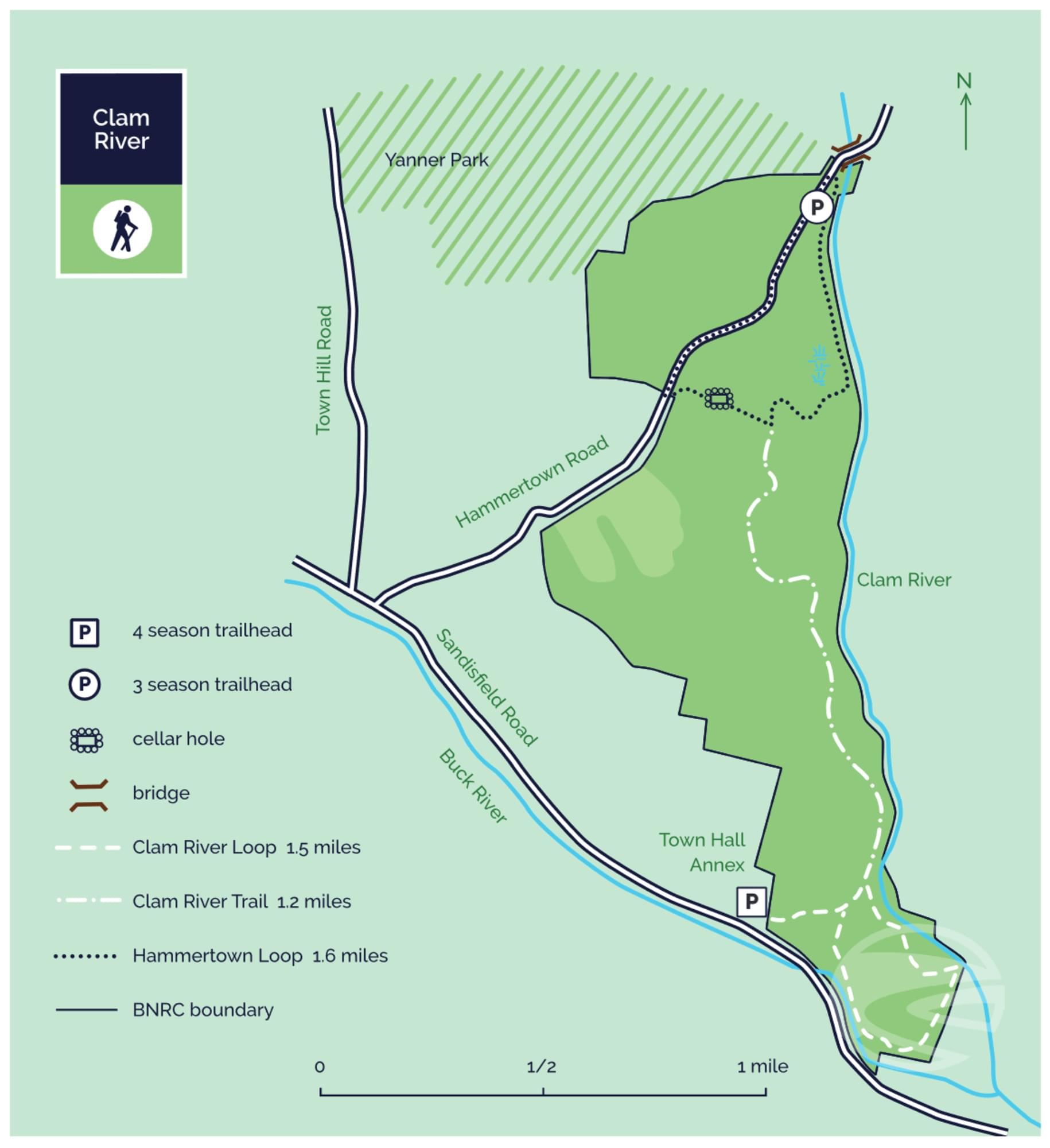
Official WebsiteClam River guide and map
About this Location
On the Clam River trails, hikers can explore 1.5 miles of this wild river and see evidence of a time when the stream and its surrounding area were not so wild: traces of a dam, extensive stone walls, and an intact house foundation. The 550-acre property offers three connected trails of 4.3 miles with moderate change in elevation.
This land, and all of the present-day Berkshires, are the ancestral homeland of the Mohican people, who were forcefully displaced to Wisconsin by European colonization. These lands continue to be of great significance to the Stockbridge-Munsee Mohican Nation today.
A tributary of the Farmington River, Clam River gets its name from freshwater mussels—not actually clams—that make their home in the river. This 550-acre preserve protects 1.5 miles of the Clam, protection that the river did not have in centuries past when settlers harnessed its power to run mills. Visitors can find evidence of that primitive engineering on the river.
Further away from its banks are the long stone walls of likely sheep farmers and a house foundation with an unusual feature: an enclosed, covered stone structure in the middle of the cellar. The foundation is on the Hammertown Loop.
In 2014 a large clearing on the south/east side of Hammertown Road was created. With the goal of creating a habitat for the endangered New England Cottontail and other young-forest species, BNRC cleared 24 acres of mature forest. As the forest grows back, bird watching and hunting should be excellent. Trace paths into the clearing can be found by adventurous hikers.
Notable Trails
Clam River Loop
From the Town Hall, you can access the Clam River Loop Trail. A 0.2-mile spur from the trailhead leads through a hardwood forest to the Loop Trail. The 1-mile loop follows old wood roads and a newly built trail through hardwood, white pine, and hemlock forests. The total length is 1.5 miles.
Clam River Trail
The Town Hall trailhead also provides access to the out-and-back Clam trail that parallels the River. From the Town Hall Annex to Hammertown Road and back is 3.3 miles. Most of the trail follows wood roads; stretches of new-built trail detour around wetlands. The trail runs along the Clam River, eventually bearing away from the river and climbing northwest past an old cellar hole, ending at Hammertown Road.
Hammertown Loop
From the Hammertown Road trailhead, the newly built trail follows the river downstream for 0.5 miles. This might be the prettiest section of a very pretty place: most of the trail is on top of steep banks overlooking the Clam River with a dense canopy of hemlocks shading steep, rocky banks. Departing from the river, the trail climbs 0.25 miles to the foundation of what must have been an imposing residence. Soon after the cellar hole, a wood road leads back to Hammertown Road; turn right and follow the Road down/north to the trailhead to complete a 1.6-mile loop.
The AllTrails website has a description and map of a hike at Clam River.
Features
Restrooms on site
Wheelchair accessible trail
Entrance fee
Content from Official Website
Last updated November 23, 2023